>
Join The Conversation!
In Today’s Blog
Latest UK-Europe Discussion @ #UK-EUROPE
Late Season Cold Shot To Bring Mountain Snows, Frost To UK, Major Hot Blast Coming To Spain Late Next Week
Latest US Discussion @ #USA
After A Cooler, Wetter April On Heels Of Super Warm March, Is More Big Heat Looming For East?
EUROPE LATEST
Late Season Cold Shot To Bring Mountain Snows, Frost To UK, Major Hot Blast Coming To Spain Late Next Week
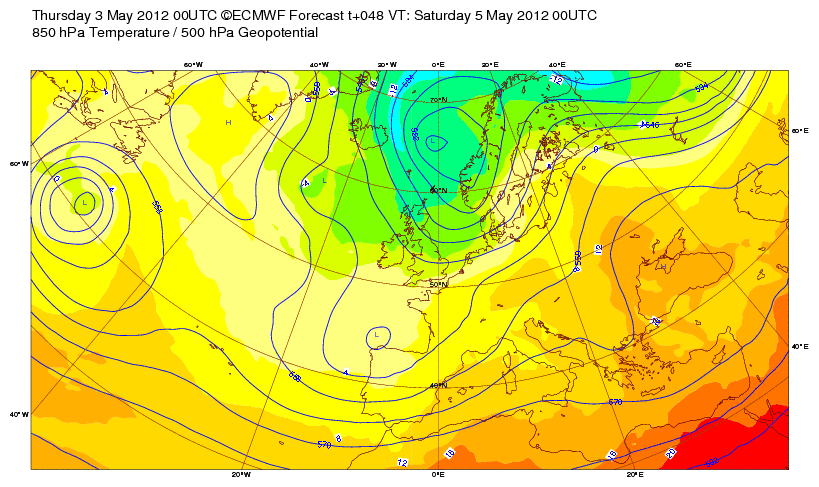
Yesterday and today has high pressure and reasonably strong heights over Scotland and so this supports modest sinking and surface warming. Yesterday saw a high of 20.1C at Kinlochewe in the Northwest Highlands, though not significantly warm, it’s the first such reading since March. That shows how we have not seen warmth and a warm bubble of air to support it at all during April.
While we enjoy a spring tease here with unbroken sunshine, the central and southern UK is not so fortunate and it’s all thanks to that stubborn southerly storm track which is riding the base of the mean trough that’s hung over us for at least 4 weeks now. The recent storm which dumped all the big rains now lingers, divorced from the main jet, between the Azores and Portugal. This upper low is keeping heights lower over the southern UK while stronger heights to the north over Scotland is allowing warmth to bleed off the continental mainland. Th reason for the waves of heavy rain pushing into the southern UK from the south is thanks to that low well to the southwest, it’s feeding fronts up. Thier decaying once into the north of England thanks to high pressure over Scotland.

COLDER AIR ON THE MARCH SOUTHWARDS TONIGHT
After a day where I got my forecasted high of 21C (not sure where though), tonight sees a southward band of rain push through central and southern Scotland and this will continue to advance southward down through England and Wales during Friday.
This is a cold front, introducing colder air from Scandinavia. While after a cloudy and damp night, skies through tomorrow morning should clear from Scotland, northern England but temps will be down to 11C for maximum readings, factor in a cool north wind and it feels rather raw for May. Showers could fall as sleet even down to around sea levels over parts of the northeast tomorrow.
England and Wales by Saturday get in on the chill with a mostly dry picture with the odd shower and perhaps even wintry one over the Pennines, Snowdonia etc as well as over the hills of Scotland. Like Friday, we could see snow down to pretty low levels across Caithness, Sutherland down through Moray and Aberdeenshire. Read more!
Mark Vogan’s 30-40 Day NAO Cycle Theory
UK Goes From 3rd Warmest/5th Driest March To Wettest April On Record, What’s Going On?
FIRSTHAND WEATHER
US LATEST
Severe Weather & Summer Heat Dominate US Pattern
Severe Thunderstorms likely to produce flooding rains, gusty, possibly damaging winds, large hail and perhaps an odd tornado extends through this evening. Watch out from the Central Plains, through the Great Lakes and into the interior Northeast/Mid-Atlantic!

Flooding Downpours Invade Mississippi, Alabama
ACCUWEATHER
Appalachian Flooding Downpours Tonight
ACCUWEATHER
Coastal California “May Gray” Continues
ACCUWEATHER

AccuWeather Release Their 2012 Summer Forecast

Hot Summer for Rockies, Plains; Great Lakes, Mid-Atlantic Stormy
ACCUWEATHER
ASIA LATEST
China Rain Replenished Drought-Shriveled Lake
ACCUWEATHER
AUSTRALIA LATEST
Stormy Weather Dominates Southeast Australia
THE EXTREMES OF THE DAY
TODAY’S US EXTREMES
COURTESY OF ACCUWEATHER
HIGH: 102° at Childress, TX
LOW: 18° at Philipsburg, MT
TODAY’S UK EXTREMES
COURTESY OF THE MET OFFICE
HIGH: 70° (20.9°C) at Tyndrum (Perthshire)
LOW: 29° (-1.7°C) at Tulloch Bridge (Highland)
TODAY’S EXTREMES HERE AT MY HOUSE
HIGH: 63°
LOW: 38°
Thanks for reading.
-Mark


Recent Comments