>
Join The Conversation!
NEW: SPECIAL VIDEO DISCUSSING DROUGHT CONCERNS AND POSSIBLE IMPLICATIONS THIS SPRING AND SUMMER ACROSS ENGLAND!
WEATHER NOTICES: HEAVY SNOW THREATENS FROM CHICAGO TO CLEVELAND TONIGHT, SEVERE WEATHER THREATENS SOUTH LATE PM AND EVENING
Today’s Global Weather Headlines
Europe Latest
‘Stacked’ SW Flow Combined With Stronger Sun Angle, Downslope Effect And Drought Will Force Highs To 17 or 18C Across Parts Of UK Today
MULTIPLE HIGHS TOPPED 18C TODAY!
MET OFFICE: It has been an exceptionally mild day across many parts of the United Kingdom. The warmest place was Coleshill (Warwickshire) with 18.7 °C, closely followed by Market Bosworth (Leicestershire) with 18.3 °C and Santon Downham (Suffolk) with 18.2 °C.
‘TODAY’S FACEBOOK UPDATE’

If you notice from today’s upper chart off the ECMWF, heights are fairly strong over southern, central England, enough to support 12-14C temps even without any wind but when you push warmth from the Azores in a ‘stacked’ fashion from upper to lower atmosphere and at the surface, your enhancing the warming effect and so the temps, rather than be in the 12-14C range given the general air mass in place on it’s own, can jump to 13-15C simply by transporting air from a warm source region into that already mild air. Now, further warming can and will take place for areas located east and northeast of hills as those surface and mid-level southwest winds will cross hills and ultimately downslope on the other side (lee side) and as they drop down the other side, they will compress and actually warm the air further! So pockets of 15-17C is likely and I believe somewhere could just manage to reach 18C, a maximum I have been shooting for since Sun.
What I believe will help some places warm, is not only the SW wind, downsloping or warmer sunshine at this time of year, but the ongoing drought conditions which can, with sunshine, heat the lower atmosphere quicker!
UK Cooldown Over Weekend (Mostly In North) But Warmer Air Returns Next Week While Eastern Europe Grows Cold Again!

Heights lower over this weekend, especially across Scotland but the current models suggest more high pressure influence once again into earl and particularly mid next week. As I see it now, I wouldn’t be surprised if we spoke of similar temps by next Wednesday as we are today across similar areas. Further east, notice when looking at the chart immediately above, eastern Europe looks to see another decent blast of very cold air at the same time western Europe sees more influence by the persistent and dominant Azores high.
Drought Concerns For Spring & Summer Ahead!
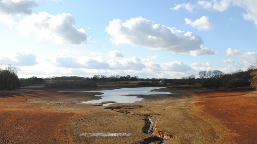
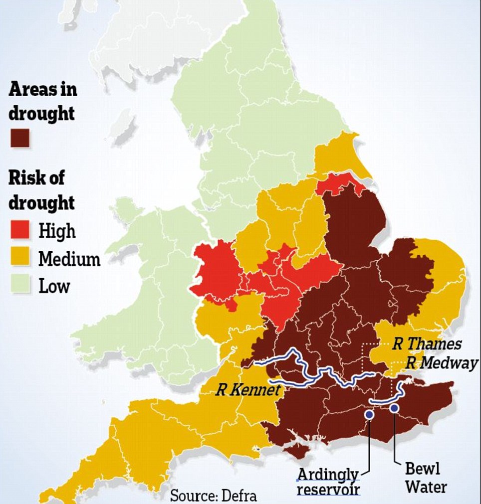
Drought risk for parts of England
BBC
US Latest
Storm System Draws In Conflicting Air Masses, Sparks Heavy Snow On Rear, Pumps Unseasonable Warmth Ahead Of It
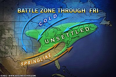
A storm system pushing into the Ohio Valley this afternoon has be responsible in dragging a reservoir of cold air down on it’s backside, enough to spark two areas of heavy snow, one across Colorado where upwards of 17,000 remain without power across the Denver area and a second area of heavy snow is impacting North and South Dakota.
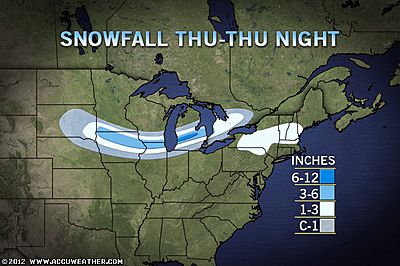
HEAVY SNOW EXPECTED FROM CHICAGO TO CLEVELAND
As this system tracks east tonight, and with the precipitation band pushing north from the OH/TN valleys, an area of heavy snow is expected to break out from Chicago through Detroit and into Cleveland. 5-10 inches is possible.
FEELING MORE LIKE APRIL THAN FEBRUARY FROM TEXAS TO NEW JERSEY

As for areas south and east of the cold front, the air today is feeling more like April rather than the last 10 days of February. While an area from Texas to South Carolina warms under sunshine and southerly winds into the upper 70s to even low 80s, the Mid-Atlantic may approach 70 degrees while up as far north as Philadelphia, we could see 65 degrees here. Upper 50s for New York City.
This morning, thanks to the seperation of the jet stream, Buffalo, NY recieved 3 inches of snow overnight while Boston, MA, on the warm side was a balmy 47 degrees this morning.
Areas of snow will clear out this afternoon across parts of upstate New York, Vermont, New Hampshire into Maine while, amazingly the warmth pushing up into Philly.
SEVERE WEATHER THREAT ACROSS SOUTH/SOUTHEAST TODAY AND ESPECIALLY TONIGHT
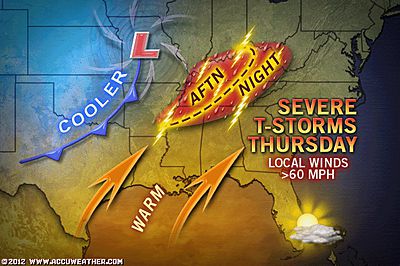
There is clearly concern as we progress through the afternoon and evening hours as the unusual warmth and humidity builds across the South ahead of the cold front, it’s as this cold front sweeps in, drawing all this energy up into the colder upper levels where thunderstorms will form fast and furious. If the atmosphere in this region doesn’t recieve the dry air from the north, keeping it ‘uncapped’, then, CAPE values soar and with very warm, moist surface air, colder air from the northwest spreading up and over this warmth, then lapse rates increase to dangerous levels. It’s this setup which helps form thunderstorms fast and with spin created by the storm’s circulation, these strong lines or clusters of thunderstorms firing along and ahead of the front could turn supercell as they spin with the atmosphere. There is a potential for some substantial severe weather breaking out, particularly from 4pm onwards.
Huge Contrast in East: Unusual Warmth vs. Snow
ACCUWEATHER.COM
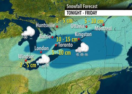
Disruptive Snow for Chicago, Detroit and Toronto
ACCUWEATHER.COM
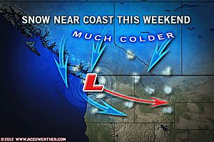
Snow May Reach Seattle Hills This Weekend
ACCUWEATHER.COM
Canada Latest
Winter set to return to the Prairies
THE WEATHER NETWORK
Series of storms blast Atlantic Canada
THE WEATHER NETWORK
Southern Ontario: biggest snowfall yet
THE WEATHER NETWORK
Australia Latest
Strong Thunderstorms Impacting Brisbane, Queensland With Flood Watches Issued In Surrounding Areas, Also Stormy Around Kimberely District of WA
THE EXTREMES OF THE DAY
TODAY’S US EXTREMES
COURTESY OF ACCUWEATHER
HIGH: 92° at Austin, TX
LOW: -2° at Thief River Falls, MN
TODAY’S UK EXTREMES
COURTESY OF THE MET OFFICE
HIGH: 66° (18.7°C) at Coleshill (Warwickshire)
LOW: 39° (4.1°C) at Wick Airport (Caithness)
TODAY’S EXTREMES HERE AT MY HOUSE
HIGH: 53°
LOW: 48°
Thanks for reading.
-Mark


Recent Comments