>
Join The Conversation!
LONG RANGE VIDEO IS AVAILABLE BELOW!
Today’s Global Weather Headlines
Europe Latest
Frigid Air Finally Reaches England Following Latest Snowfall!

The truely frigid air has finally reached the UK after many thought would remain on the other side of the North Sea. Temperatures have recently dove to -13C even along the Dutch coast while eastern areas near the German border plunged to -22.9C(-9F), the lowest values in 27 years while their eastern neighbours, Germany shivered in their coldest temperatures in some 25 with a -29C reached at Usedom Island on the Baltic Sea but it was as coldest as -28C on the mainland, -20C in Berlin.
The Azores high is too strong and dominant is what many thought, however, as we watched the cold continue west and reach so close, I did believe it was only a matter of time and of course, like we’ve seen throughout the Siberian express’s journey across the continent, fresh snows just west of the polar boundary seemingly lay down extended tracks in which this bitter train of cold could run along. This proved to be the case for eastern England as well as the Low Countries this morning. Interestingly, it was another frigid morning over there too with at least -12C (10F) recorded at Brussels, Belg and -10C (14F) at Amsterdam.
I am very interested as to just how this February will compare to history in terms of cold as not only the intensity has been impressive but the persistency is also becoming very impressive.

Following nightmarish travel headaches due to heavy snow throughout the Low Countries, that night saw clear skies, light winds and the brutally cold air mass float overhead, drawn further west by fresh snow cover which saw Amsterdam plunge to -18C (0F).
Interestingly, just 36 hours ago, we saw fresh snowfall across many parts of England and of course this encourageed the frigid air across the North Sea. Clear skies, a colder air mass aloft, fresh snowcovered ground and light winds, drove temperatures well below -10C from S. Yorkshire to just outwith the M25. Several places saw lows fall below -12, even -14C with the lowest reading appearing to be Chesham, Buckinghamshire where a low of -17.8C was recorded. The moral here is this, by watching how this cold has evolved and tracked and the fact that many saw fresh snow followed by severe cold, meant that following the recent snows, it’s no big surprise that we saw the Siberian express cross the North Sea. Once nature lays down a fresh carpet of reflective white and the tracks run that little further west for the Siberian express, it’s amazing what can happen.
US Latest
Frigid Air Returns To N. Plains While Snow Lays White Carpet For It’s Eastward Migration Into Northeast Sunday
Snow whitening the ground throughout the Ohio Valley and Northeast will push out and into Atlantic Canada tonight, opening the door for Arctic air to roar in!

Coastal Storm, Snow Squalls Wreaking Havoc in the East
ACCUWEATHER.COM
Blast of Arctic Air to Follow Eastern Snows
ACCUWEATHER.COM


Canada Latest
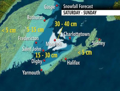
American Northeast Snow System To Become Atlantic Canada Blizzard Tonight

Weekend Blizzard, Wind, Rain for Atlantic Canada
ACCUWEATHER.COM
Winter storm looms for Atlantic Canada
THE WEATHER NETWORK
Winter weather returns to southern Ontario
THE WEATHER NETWORK
Australia Latest
New South Wales Experiences More Flooding Storms
THE EXTREMES OF THE DAY
TODAY’S US EXTREMES
COURTESY OF ACCUWEATHER
HIGH: 83° at Gila Bend, AZ
LOW: -20° at Fosston, MN
TODAY’S UK EXTREMES
COURTESY OF THE MET OFFICE
HIGH: 51° (10.5°C) at Castlederg (Tyrone)
LOW: 4° (-15.6°C) at Holbeach (Lincolnshire)
TODAY’S EXTREMES HERE AT MY HOUSE
HIGH: 41°
LOW: 36°
Thanks for reading.
-Mark


Recent Comments