>
Join The Conversation!
BREAKING WEATHER: HEAVY SNOWS BREAKING OUT ACROSS WISCONSIN, N. ILLINOIS AND MICHIGAN, TRAVEL DISRUPTION IS LIKELY (See below!
Today’s Global Weather Headlines
Europe Latest
Winter Hangs On Across England/Wales, Different Story Across Ireland, N.I and Scotland
TONIGHT
Cloudy, relatively mild over Ireland, N.I, Scotland, Cool across North of England and clearer, cold from N. Midlands southwards

It’s a tale of two air masses over the UK these days. While it may dip to freezing pretty much anywhere over England and Wales tonight, it’s from the north Midlands down into south-central England where skies are clearest and temperatures will drop off to between -4 to -8C widely. Areas where fresh snow lies, an added boost of cooling will drive temperatures in some spots to -10, perhaps a degree or so lower by tomorrow morning.
As for Ireland, Northern Ireland and Scotland, milder, Atlantic air rules with temperatures remaining above freezing, skies are generally cloudy and we could see some overnight rain in places.
SATURDAY
Generally bright and sunny but cold from Manchester to London, Cloudier, mild over Ireland, N.I, Scotland
Saturday looks generally cloudy and mild with a light southwesterly breeze blowing. Anywhere which saw overnight rain, should see drying but skies will likely remain cloudy.
While skies cloud over during the overnight across northern England, skies should remain generally bright and sunny from Manchester southwards but that sun won’t do much to the temperatures as I’m expecting a mere 2-3C for most.
Like my videos? Subscribe to my YouTube Channel
Britain Is Seperated Between Mild, Atlantic Air And Cold, Continental Air
Though Britain hasn’t seen the widespread snow and deep cold of the past two winters, there certainly is no shortage of winter weather across large swathes of England and Wales with icestorms in the north and heavy snow from Yorkshire southwards to Kent.
While I drove southbound on the M74 en-route to Carlisle yesterday morning, heavy rains hit my windscreen while temps were sitting at -1C (30F) and this combination caused ice to form on the front of my truck and mirrors. I saw tracks form on the road surface which wasn’t due to snow, sleet or rain. In my opinion it was a glaze of ice forming on the surface. This of course is much more dangerous than snowcovered roads as most don’t realise the road surface has become an ice risk. When stepping out of my truck in Orton Grange, just outside of Carlisle to make my delivery, the car park was starting to ice over with the below freezing temps and persistent rainfall.
The worst of the conditions appeared to be over the A66 Trans-Pennine route linking the M6 Cumbria with the A1 in N. Yorkshire. This road, crossing the exposed tops of the north Peninnes was fully exposed to the rain and cold temps which turned this busy route into one solid sheet of ice.. Catching multiple vehicles off guard.
Not often do we experience freezing rain and icestorms but this has become a well documented part of this winter.
Today, like the past few will see wet, dull and mild conditions throughout Ireland, Northern Ireland and Scotland while from Cumbria south, continental air remains strong and therefore the ice risks remain and more snow showers are likely from Yorkshire south.
Temps range from 6-10C across Ireland and Scotland, 3-5C in north of England and 1-2C in central and south of England.

Severe weather warning for weekend
BBC
Little snow but ice hits roads, crash affects A470 near Nant Ddu
BBC
Freezing rain causes more than 100 crashes in Cumbria
BBC

Frigid Air Remains Across Europe
Major Snowstorm Setting In Across Italy, Balkans
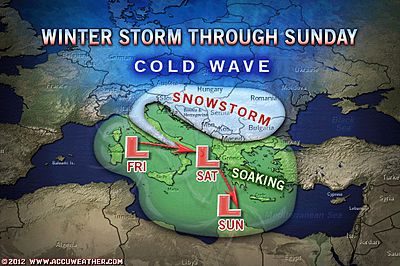
Weekend Snow for Italy, Balkans
ACCUWEATHER.COM
Great video from my Facebook friend Massimiliano Rossi of the snow and strong winds impacting Ancona, Italy today!

Frozen sea: Cold snap traps ships in Kerch Strait
BBC
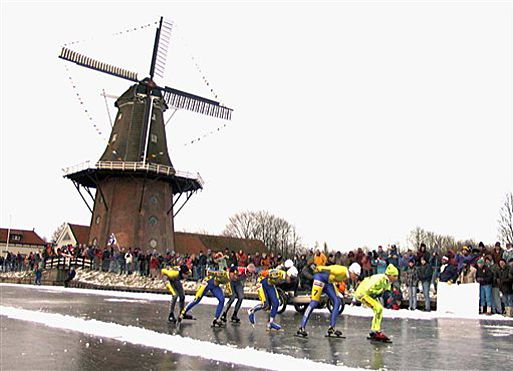
High Hopes for First Dutch Skating Marathon in 15 Years
ACCUWEATHER.COM
US Latest
Snow And Arctic Air Returns To The Forecast
Finally, some arctic air returns to the Northern Plains, system to bring 2-4 inches of snow from Philadelphia to Boston.. Sunday remains in the 20s from DC to Boston while Sun night looks frigid!
Subscribe to my FACEBOOK & Twitter pages for frequent US weather updates
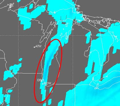
BREAKING WEATHER: HEAVY SNOWS BREAKING OUT ACROSS WISCONSIN, N. ILLINOIS AND MICHIGAN, TRAVEL DISRUPTION IS LIKELY!
NEW VIDEO: Chicago Whiteout
ACCUWEATHER.COM

Nasty weather is now sweeping into the Chicagoland area as an Arctic front approaches the area

Lake-Effect Snow Aims for Chicago, NW Indiana
THE WEATHER CHANNEL
Northeast Snow This Weekend
THE WEATHER CHANNEL
Snowstorm Aims for Boston, Hartford, Providence
ACCUWEATHER.COM

Australia Latest
THE EXTREMES OF THE DAY
TODAY’S US EXTREMES
COURTESY OF ACCUWEATHER
HIGH: 86° at Borrego Springs, CA
LOW: -18° at Flag Island, MN
TODAY’S UK EXTREMES
COURTESY OF THE MET OFFICE
HIGH: 53° (11.4°C) at Magilligan (Londonderry)
LOW: 18° (-7.9°C) at Houghton Hall (Norfolk)
TODAY’S EXTREMES HERE AT MY HOUSE
HIGH: 40°
LOW: 39°
Thanks for reading.
-Mark


Recent Comments