>
Join The Conversation!
NEW LONG RANGE VIDEO AVAILABLE (SCROLL DOWN)
Today’s Weather Headlines
Europe Latest
Very windy and at times wet weekend in store for UK-Ireland
Through tonight, you’ll notice the rains easing, especially northern areas as a front which brought today’s rainfall to many areas sweeps east out into the Northg Sea, eventually bringing wet and eventually blustery conditions to the Low Countries.
While skies clear of rain tonight over Ireland and the UK, winds pick up and will blow strongly out of the west throughout this weekend. While 35-60 mph gusts may impact anywhere with highest winds along west facing coasts, it’s up over the Highlands and far north of Scotland where winds not only blow at gale-force with gusts potentially reaching 80 mph in exposed areas but temps will be coolest here and if there’s not frequent rain showers blown in on this howlling wind, snow may be an issue, even at lower levels making for treacherous driving conditions.
A slushy covering of wet snow was on the ground just 20 minutes south of Glasgow

Though sleet and rain impacted most low lying areas early this morning with sleet falling heavily here at my house, I headed down the M74 at 1.30am this morning only to be greeted by snow/slush covered roads just as the motorway begins the climb up into the northern flank of the Southern Uplands. My first drop was at Stonehouse where the road was snow and slush covered. Interestingly, once I headed beyond Blackwood and Lesmahagow where elevation isn’t particularly significant, perhaps 500-800 feet above sea level, it was here where the snow was worst, lying to a depth of roughly a half to 1 inch.
Ice was in fact more of an issue due to frequent showers followed by clear spells, cold ground and air temp near freezing. It was the perfect combination for black ice and there was plenty of it this morning. Many accidents were attributed to ice this morning across many parts of Scotland.
Long Range Latest
Hemispheric & Europe Pattern showing signs of coming round to my ideas issued back on Christmas Day
SIGNIFICANT ARCTIC OUTBREAK MAY IMPACT MULTIPLE MID-LATITUDE AREAS IN FEBRUARY 2012
STRONG POSITIVE AO/NAO FOR SUSTAINED PERIOD, FOLLOWED BY STRONG STRAT WARMING AND POTENTIALLY STRONG NEGATIVE AO/NAO MAY BRING MAJOR ISSUES ACROSS THE HEMISPHERE DURING FEBRUARY
Given the persistency in models TANKING the AO and NAO from Jan 26 onwards combined with a strong stratospheric warming event over top of the pole and the shear persistency in a strong positive AO/NAO during December suggests not only a colder period looming for N.A, Europ, Asia, but I believe we’re heading for a significant and tough next 30-day period of winter.
I predict, that during February A MAJOR, POSSIBLY RECORD BREAKING ARCTIC OUTBREAK will impact a large portion of the USA while the UK, as forecasted way back in summer, may take a run at the severity of cold experienced last year with heavy snows laying down a near nationwide blanket of snow which could arrive before January is out, this I believe could be followed an an arctic high and significant cold spell.
Keep in mind folks that although winter’s worst was in late November and throughout December last year, winter was done for the season afterwards. Like I’ve stated previously, 2009-10 was a worse winter than last year despite a much colder period. how? though the worst was seen between Dec 18-Jan 10 in 09-10, we saw repeat heavy snow and cold spells during Feb-March which made for a worse winter when combining the three meteorological winter months (Dec-Feb).
Reasons for my bold for cold forecast!
We’ve seen a modest strat warming event which allowed weakening westerlies and the release of arctic air into the USA, eastern Europe and eastern Asia but this, albeit a much colder outbreak than models anticipated was restricted by a weak ‘negative’ AO and a barely neutral NAO. Basically, the full potential was far from met given the amount of time this arctic air has been allowed to build, however. latest modelling for the 10mb strat levels shows full warming at 10mb over the pole. (see graphic below)

Note the weak warming with lots of blue either side. However, notice the full warming at the end of this chart!
This tells me the arctic reservoir is set to spill southwards whilst blocking highs reach and replace this frigid air over the pole. What backs this idea up?
Note the below AO/NAO charts BOTH show a tanking deep into negative territory!
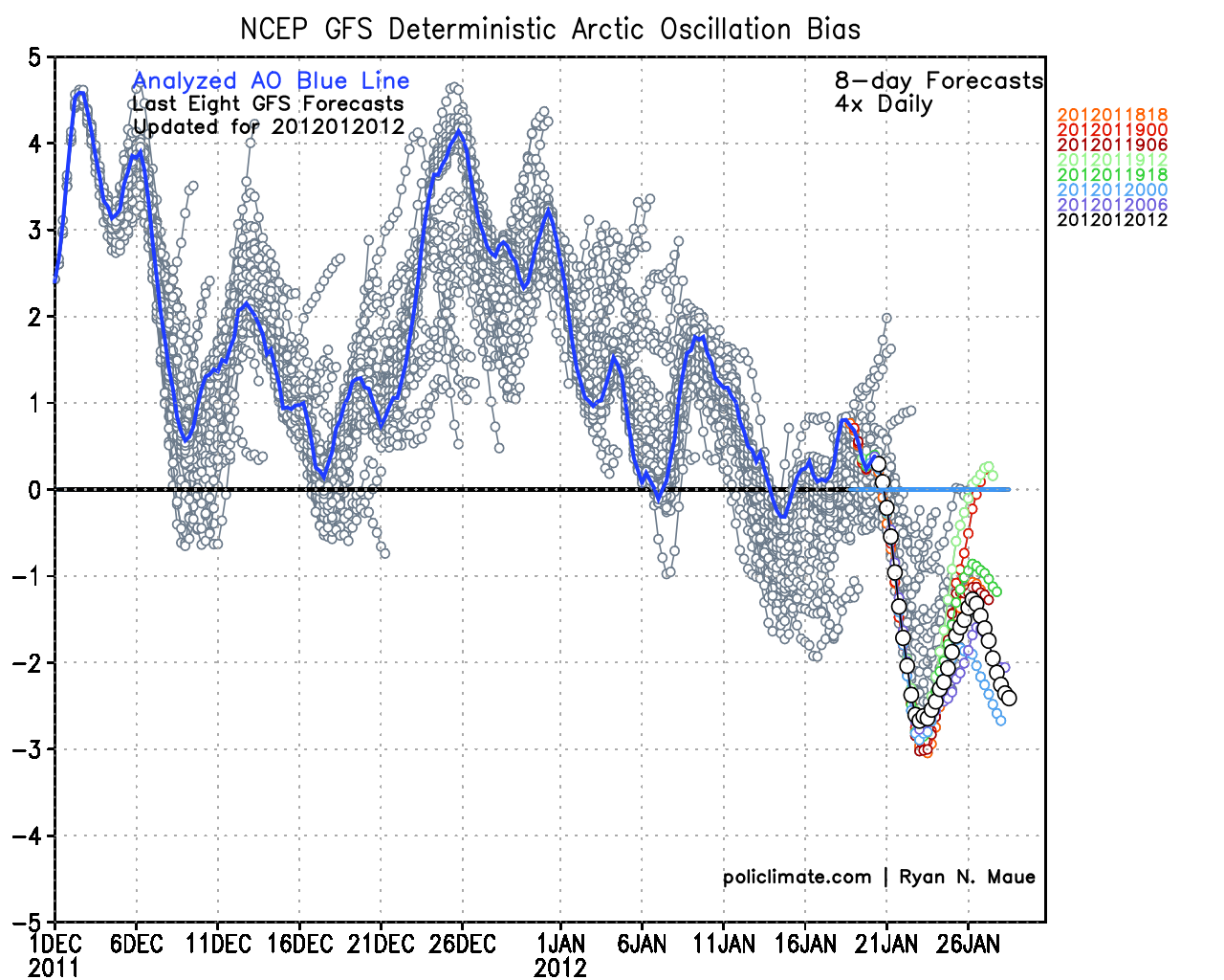
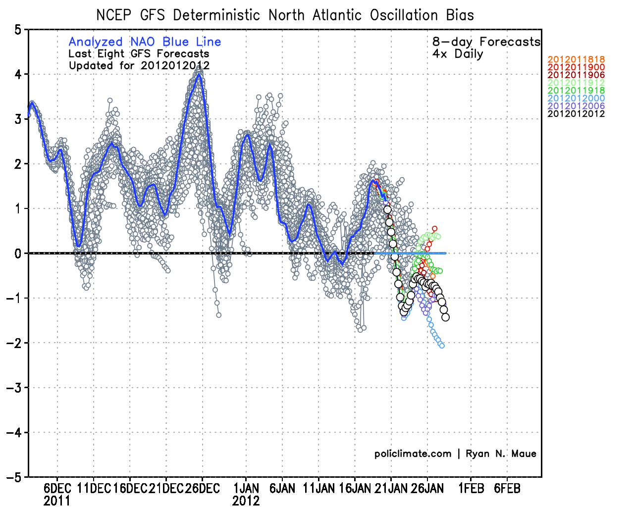
Charts courtesy of policlimate.com
US Latest
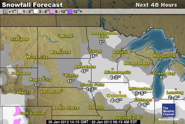
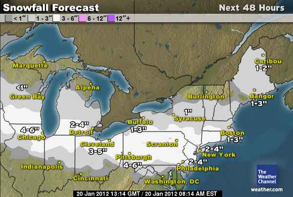
2-8 inch swath of snow to fall from Iowa to Massachussetts, including NYC, possibly Philly
The same system which caused havoc in parts of the Pacific Northwest in recent days including record snows followed by an ice storm in the Seattle area is now pressing east into the Ohio Valley. Although it’s not the strongest of systems, what it has is a substantial reservoir of very cold, arctic air to tap to it’s north and mild, moist air to it’s south and between the two, a significant corridor of 3-6 inch snows will bring plenty of travel problems from Chicago through Detroit, Cleveland all the way to NYC and Boston, perhaps dropping a few inches across Philadelphia too.
I guess the lack of proper winter weather during December and early January will make this seem a bigger deal than say this same event occuring at this time last year, given what the front part of winter was like across this region last year. It will be very welcome indeed for those snow lovers out there that’s for sure.
Stories
280 flights canceled as airports brace for snowstorm that could bring more than 6 inches
CHICAGO TRIBUNE

Snow for Chicago, Detroit, Cleveland, NYC, Boston
ACCUWEATHER.COM

No Changes on Friday-Saturday Storm
FIRSTHANDWEATHER
Snowstorm for NYC, Hartford, Boston and Others
ACCUWEATHER.COM
Winter Storm Targets Midwest and Northeast
THE WEATHER CHANNEL
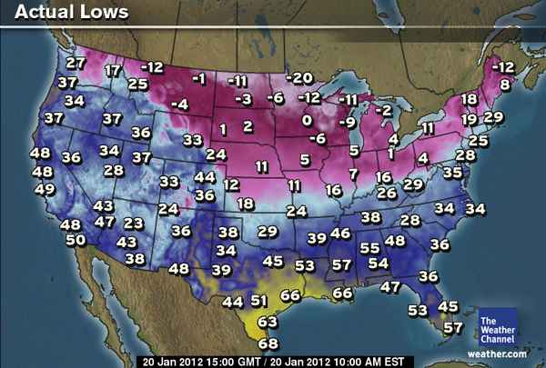
Another very cold start across N. Plains, Midwest
Canada Latest
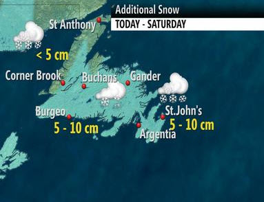
Big Storm shuts down Newfoundland schools, Arctic air holds firm nationwide
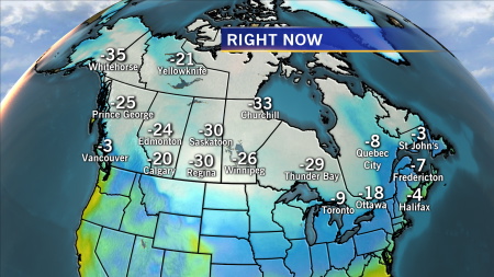
Heavy snow prompts school closures in Newfoundland
THE WEATHER NETWORK
Asia Latest
Tokyo sees first snowfall of winter 2011-12
Tokyo area hit with season’s first snowfall
THE MAINICHE DAILY NEWS
Australia Latest
Plenty of active weather across Australia
Africa Latest
Rapidly intensifying Tropical Cyclone Funso to get close to Mozambique bringing further flooding rains, strong winds
THE EXTREMES OF THE DAY
TODAY’S US EXTREMES
COURTESY OF ACCUWEATHER
HIGH: 88° at McAllen, TX
LOW: -27° at Cook, MN
TODAY’S UK EXTREMES
COURTESY OF THE MET OFFICE
HIGH: 53° (11.5°C) at Exeter Airport (Devon)
LOW: 30° (-1°C) at Leuchers (Fife)
TODAY’S EXTREMES HERE AT MY HOUSE
HIGH: 47°
LOW: 31°
Thanks for reading.
-Mark


Recent Comments