>
Join The Conversation!
Today’s Weather Headlines
Europe & Long Range Latest
Turning Wetter & Windier across UK Followed By Colder Northwest Flow Thursday & Friday
WIND WARNING: Wind gusts of 50-70 mph are expected from a westerly direction from the Central Belt southwards through the north of England Wednesday night/early Thursday morning
UK OUTLOOK
Through tonight, a cold front associated with a low to the north will bring a rapid increase in west winds along with a band of persistent rain which will move south through the overnight into Thursday morning. The strongest winds are expected to cross the Central Lowlands and down through Dumfries and Galloway/Borders and into the north of England where gusts of 50-70 mph could be experienced widely. This cold front as it sweeps south gradually will bring rain south into the Midlands by morning though the rains become lighter and patchier and winds too will weaken.
Once the front clears to the south, it will feel a good deal colder over Scotland and the north of England thanks to a more northwest flow rather than mild westerly. This change allows colder origin air to draw southeast from Iceland and instead of the mild temps last night, it should cool with a windchill to contend with by morning while the Midlands southwards remain south of the front, with temps mild.
Tomorrow looks damp, drizzly and perhaps misty over areas where the front lingers and that’s from the Midlands southwards while skies will be brighter but feeling a lot colder north of the front. Highs across Scotland and the north of England will likely only range from 4-7C but factor in the northwest breeze and it may feel closer to 2 or 3C through tomorrow. Before sunrise in the morning, it may well feel like it’s below freezing with the temp falling to 2-4C overnight as the colder air gets pulled in behind the cold front.
Mild December plays tricks on UK plant life
BBC
Today’s Long Range Thoughts
SUBSCRIBE TO MY YOUTUBE CHANNEL
My Thoughts From Facebook…
“Strat cooling has been occuring over recent days following a maxing out of the warming which will show itself across Europe and North America over the next 10 days. Brief milder surge is likely before Feb begins. However, the new warming event which has commenced will be stronger than the last and thus Feb may turn out wilder than what may or may not occur from now until the end of the month. Next 10 days. both Europe and Canada/northern US looks VERY COLD and it’ll turn out a lot colder than models will predict!”
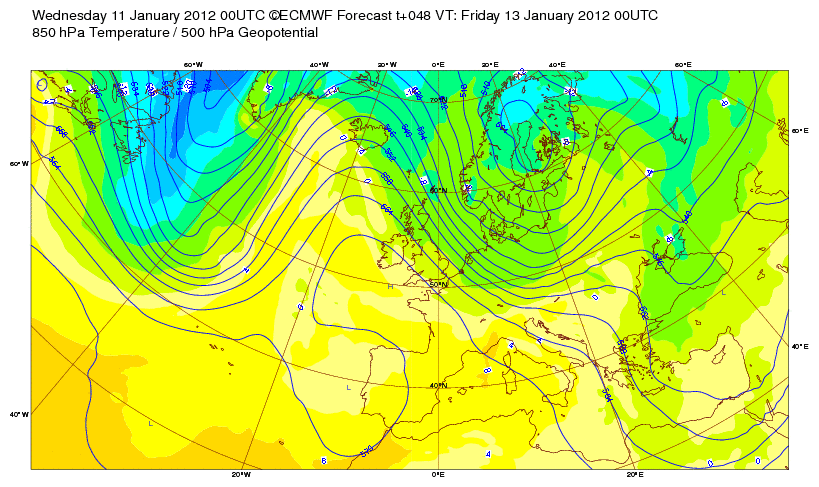
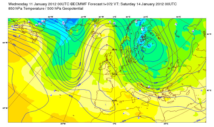
“Once tonight’s low pushes through UK and eventually Scandi next 36 hours, that’s when the cold pool expands and intensifies over northern/eastern Europe. Will be interested to see how far west it spreads!!”
You can see this is the latest runs of the ECMWF which has been persistent in developing this cold trough which grows colder and colder….


‘LIKE IT’ and see them frequently…
US Latest
First Major Winter Storm Takes Aim At Midwest, A lot of Cold to Drop South From Canada Next 10 Days
Over the next several days folks the weather will turn downright dangerous across the Midwest and Lakes where a surge of very cold air will drive down from Manitoba and Ontario meeting a storm system which will bring strong winds, low temperatures and heavy snow and this nasty combo will bring blizzard conditions to areas highlighted in the below graphics.

Following the heavy snow comes colder air which is still way up over northern Canada and this combined with gusty northwest winds will make it extra dangerous I believe given how mild it’s been. This is going to be a harsh reality to what should be typically cold. It will be like going from spring to a midwinter cold spell.
Next week looks even colder than what we’ll see over the next few days where Minneapolis may remain below zero for at least a day with lows below -10. Chicago may remain in single digits with subzero lows. The snowcover will be greatly extended!
Midwest: Say It Is Snow!
THE WEATHER CHANNEL
Dramatic Freezeup, Snow Bursts Midwest to Appalachians
ACCUWEATHER.COM

From Record Highs to Bitter Cold in 24 Hours
ACCUWEATHER.COM


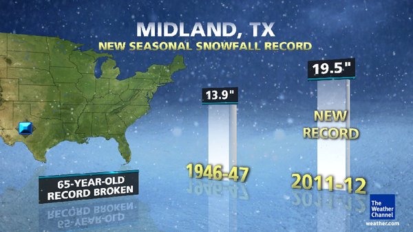
Snow Capitol: Midland, Texas?
West Texas is the place to be for snow this year! While much of the Midwest has barely seen it snow, Midland, TX has experienced their snowiest winter on record (already).
Winter Snow Capital: West Texas?
THE WEATHER CHANNEL
An Incredibly Snowless Winter In A Typically Snowy Region, This Is Set To Change
Brown Ground Abounds
In mid-January, brown ground is the rule, rather than the exception in the Midwest. According to the NOAA/NOHRSC, a mere 15.8% of the Lower 48 States had snow on the ground Tuesday. Last year at this time, that figure was just under 62%.
Through January 10, only 3 other seasons have started out with less snow in Chicago than the current paltry 1.9″.
The Weather Channel


Canada Latest
Dramatic Flip In Temperature Over ALL Of Canada Next 7 Days
Jet stream to blame for snowless winter
THE WEATHER NETWORK
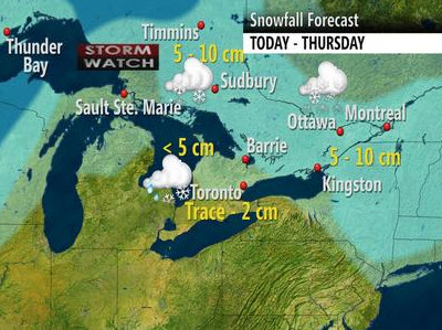
Messy mix on the way for central, eastern Canada
THE WEATHER NETWORK
Australia Latest
Vastly Contrasting Weather Impacting Australia With Cold Snap On One Side, Tropical Cyclone On Other

Cyclone Heidi bears down on WA town
ABC NEWS
Australia Port Shut as Cyclone Heidi Bears Down
ACCUWEATHER.COM
THE EXTREMES OF THE DAY
TODAY’S US EXTREMES
COURTESY OF ACCUWEATHER
HIGH: 84 at Edinburg, TX
LOW: -19 at Clayton Lake, ME
TODAY’S EXTREMES HERE AT MY HOUSE
HIGH: 49
LOW: 40
Thanks for reading.
-Mark


Recent Comments