>
Latest UK-Europe Discussion @ #BRITISH ISLES-EUROPE
Models show the Arctic Oscillation flipping negative and to be followed by North Atlantic Oscillation, what does this mean for the UK-Ireland and western Europe?
Latest Weather from India-Sub-Continent @ #INDIA-SUB CONT
Latest Indian-Sub Continental Weather News from Rajesh Kapadia
Now Available @ #LONG RANGE!
Mark Vogan’s Official 2011-2012 United Kingdom & Europe Winter Forecast
Today’s Weather Headlines
Europe Latest
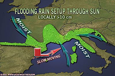
Same system which flooded Genoa has now down it’s dirsty work on the Bagnols-en-Foret area of southern France
‘Cold air drawn in and wrapped around an area of low presssure over the very warm waters of the western Mediterranean create a perfect environment for exceptional downpours.
This colder air slides into a warmer environment by air and water beneath which forces strong ‘lift’ and development of thunderstorms along the entensifying cold front. The strong, gale-force southerly flow racing ahead of the cold front forces this area of ‘extreme upward motion’ northwards up into southern France and Italy.
This combined with the ‘orographic effect’ caused by the sloping terrain from coast to Alpine foothills creates even heavier rainfall. The result is flash flooding and both northwest Italy and now southern France has seen deaths caused by this wild weather.

Heavy rains, flooding force evacuations in southern France
THE WEATHER NETWORK
France hit by storms in south, three dead
REUTERS UK
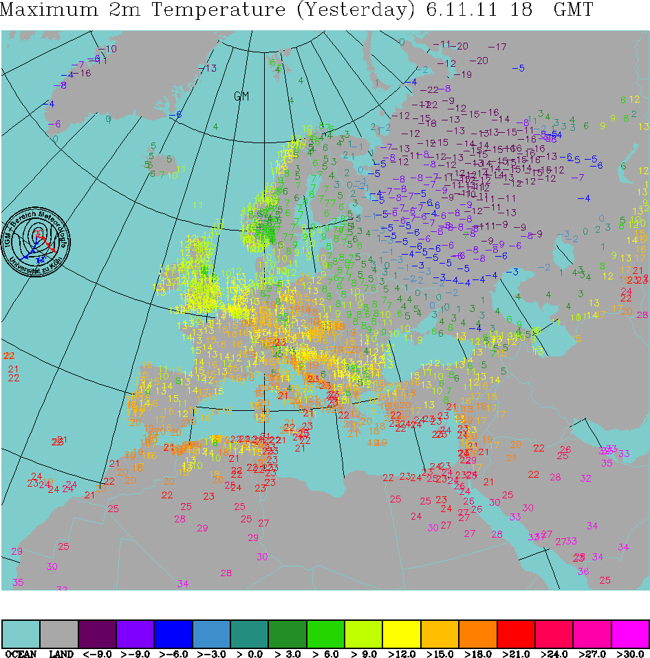
Frigid Sunday across european Russia
FRIGID ACROSS EUROPEAN RUSSIA: It was yet another very cold day throughout european Russia on Sunday.
‘Western european Russia’ warmed to no better than -4 or -5C while ‘eastern european Russia’ warmed to no better than -11 to -16C yesterday, far north and east saw ‘high’s on -20 to -22C, yes, highs!.
Most places endured overnight readings ranging from a relatively ‘mild’ -10C in Moscow to -18C in outlying suburbs, even colder with -25C well to the north and east of the capital!
US Latest
Rough Day ahead on the Plains
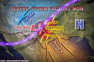
Severe Weather Outbreak Across Southern Plains Today
ACCUWEATHER.COM

Storm Could Slam Northwest This Weekend
ACCUWEATHER.COM

Failure to get connected in Connecticut, Residents enter 2nd week without power

Still No Power for Thousands in Northeast After October Snowstorm
FOX NEWS
Canada Latest
Praries blanketed by first significant snowstorm while it remains mild across southern Ontario
A large contrast between Regina and Toronto.
While the Praries recieve their first significant snowstorm followed by their first cold blast, it’s balmy across southern Ontario today. A few hours ago, while it was a brisk -14C in Regina, SK, Toronto, ON was basking in 15C. That’s a huge 29C temperature difference.
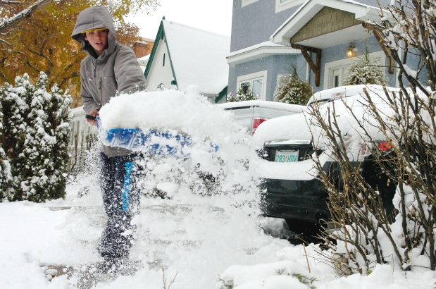
REGINA, SASK – Brandon Krewenchuk shovels a driveway in Regina on Sunday Nov. 6, 2011. Photograph by: Michael Bell, Regina Leader-Post
Wintery system sweeps Praries
THE WEATHER NETWORK
Winter weather warnings across Sask.
CTV REGINA
City, province get a taste of winter weather
CTV SASKATOON
‘Colorado Low’ brings snow
THE STAR PHOENIX
Asia Latest
It’s relentless, Flood waters continue to rise in Bangkok, Thailand
Thailand flood death toll passes 500
CBS NEWS
Concerns, floodwaters rise in Bangkok
CNN
City Hall wins battle for pumps
BANGKOK POST
THE EXTREMES OF THE DAY
TODAY’S US EXTREMES
COURTESY OF ACCUWEATHER
HIGH: 90° at McAllen, TX
LOW: -2° at Butte, MT
TODAY’S UK EXTREMES
COURTESY OF THE MET OFFICE
HIGH: 59° (14.9°C) Kinlochewe (NW Highland)
LOW: 21° (-6.1°C) Redesdale Camp (Northumberland)
TODAY’S EXTREMES HERE AT MY HOUSE
HIGH: 47°
LOW: 30°
Thanks for reading.
-Mark


Recent Comments