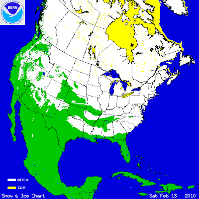
>Snow covered ground from Canada all the way to the Alabama-Florida line helping cool the lower atmosphere and bringing the freezing line down to central Florida this morning…
 live webcam vew from Sears Tower this morning
A beautiful fresh February morning. Lows in Chicago around 10 degrees, winds making it feel near zero degrees.
Link:
 Link: http://www.natice.noaa.gov/pub/ims_gif/ARCHIVE/NHem/2010/ims2010044.gif
 (Courtesy of Intellicast Weather)
It’s not a terribly cold start to a February 14th morning but what’s impressive is just seeing a solid snowpack stretch from the Alabama-Florida border all the way to the Vermont-Quebec border.
There is also sub-freezing air stretching from Northern Florida to Canada and very much helped by the snowcover refridgeration effect. Arctic air is, if any, covering the 1-3 foot glacier of the Northern Plains (particularly N. Dak and Minnesota) where morning readings as per typical this season are in the single digits with sub zero winds chills. Another highly concentrated snowpack region is of course across the ground zero of recent storms, the Middle Atlantic where some areas of Penn, western Maryland, Virginia and West Virginia have a snow depth in places of 2-4 feet! Check out Jesse Ferrell’s recent blog which discusses snow totals from both blizzards…
Saturday, February 13, 2010 9:36 AM
Mid-Atl Double Blizzard Totals 55 Inches, Records by Jesse Ferrell, AccuWeather.com
Mid-Atl Double Blizzard Totals 55 Inches, Records by Jesse Ferrell, AccuWeather.com
A-Class for skiing in the Mid-Atlantic resorts
Thanks for reading.
-Mark


>And here was me thinking it snowed each winter in the states? Maybe us lucky UK folk should send them some food parcels til the unusual sprinkle of snow melts and they can get back to growing rice.
Timmy Mallet