>
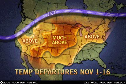
The contrast couldn’t be greater between Oct 1-31 and Nov 1-16. It’s simple. the Arctic Oscillation was negative in October and now currently positive and therefore explaining why we are seeing cuh warmth across the United States. I have explained a while back that this would be the case across the US. Now, let me point out something to you. The signs of change are lurking on the northern horizon. The massive blob of Arctic air entrenched over much of landlocked Asia is moving in progression with the season and now some of that bitter cold is starting to ripple across Alaska. With a -44 at Huslia, AK, the first signs of real winter weather is arriving to the very places we want to see get cold for a down-the-road winter show across the lower 48. We need to see INTENSE cold build over this region for when the flip occurs, we will of course see moderation in this air mass as it eventually heads south on a meridional or highly amplified jet as the availability of daylight and sun’s energy is higher as you head further south. So in order to witness EXTREME cold, we need very severe cold in the key source regions FIRST and that is what we’re seeing.
 Another major key to remember, for us to see this intense cold stay intense over the lower 48, we must try and have Alaska and the frozen northerly latitudes hold on to the core of the cold as long as possible and as closer to the “heart of winter” as possible so that we maximize all things cold. i.e. minimal sunlight as far south as possible, water temps on both sides of the continent need to cool off some from summer to lessen the modification of the southward prgression of Arctic air and also we want to see it get as cold up there as possible before it’s release.
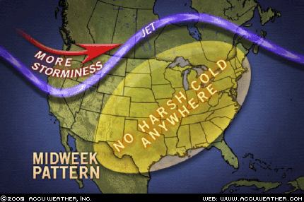 For a truely cold December, the current warmth that’s spread across the lower 48 is a GOOD thing since we don’t want to to get cold too early and then have the Arctic reload mid-winter as days grow longer again, even by early January days are growing longer, remember that!


>"With a -44 at Huslia, AK, the first signs of real winter weather is arriving to the very places we want to see get cold for a down-the-road winter show across the lower 48."
Why do you want us to freeze? We have no money to heat our homes…