>Follow the Blog on Facebook & Twitter
TODAY’S TOP WEATHER STORIES
On Weather & Climate Through the Eyes of Mark Vogan
BRUTALLY COLD ACROSS MIDWEST BUT CORE NOW ADVANCING THROUGH ONTARIO TOWARDS QUEBEC & NORTHEAST WHERE IT WAS COLD THIS MORNING BUT WILL BE COLDER TOMORROW MORNING!
SEE BELOW, YOUR LOCAL VIDEO FORECAST FOR YOUR AREA!

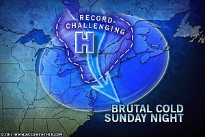
NORTHEAST US TONIGHT: POSSIBLY THE COLDEST SINCE 2005, EVEN 2004
By Mark Vogan
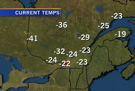
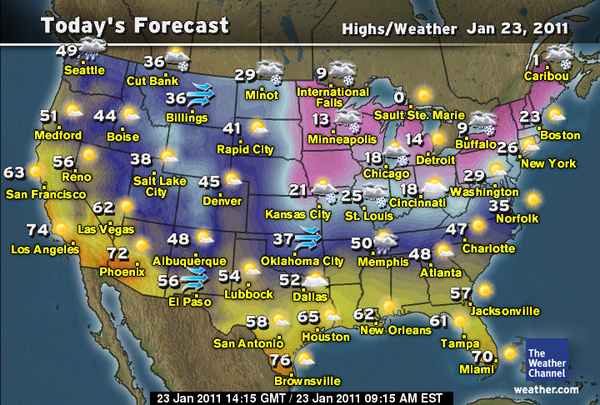
With the core of the polar vortex spinning over Hudson Bay and throwing fresh pieces of super cold air across Ontario and Quebec, skies are scarce of clouds and thus with the vast expanse of reflective snowfields of this frigid region, temperatures will recover today to only between -15 and -20C over the southern region, -20 to -30C over central Ontario and Quebec. As the day progresses, the core of this air will continue advancing southwards towards the American Northeast where highs will warm to between -9C and -4C (18-25F) from Philadelphia to Boston today and through late today and tonight a front will swing through, marked only by some high clouds, behind it, that very air that’s currently over Ontario and Quebec and the same stuff that produced the -16F in Minneapolis and -46F in International Falls will cover New England and into the big cities. The major cities of the Mid-Atlantic and Northeast will be presented with this very air tonight. Believe me, your air right now, isn’t cold! The only thing that’s making today’s air cold is “nippy” windchills. Your mid-20s of today will be upper teens tomorrow and this morning’s low teens will be mid 0s if not low 0s from Philadelphia through Trenton, New York tomorrow morning when you get up. I do believe a -5 to -9F is possible from Hartford, Providence to Boston tonight and -20 in far northern, northwestern counties of Connecticut and western counties of Massachussetts. The valleys deep within the Adirondacks of New York state, the valleys of Vermont, New Hampshire and far northern Maine should see lows between -20 and -40F, brisk Arctic breezes may send windchills to between -30 and -45F.
The Really Cold Spots tonight/tomorrow morning
Berlin, NH -25F
Saranac Lake, NY -30F
Caribou, ME -32F
Presque Isle, ME -35F
TODAY’S WEATHER ACROSS AMERICA
From AccuWeather
Bone-Chilling, Dangerous Cold in East
By Meghan Evans, Meteorologist
Treacherous Travel for Kansas City, St Louis, Louisville
By Katie Storbeck, Meteorologist
Frigid Temps at NFL Conference Championships
By Gina Cherundolo, AccuWeather.com Staff Writer
WEATHER TALK
By Mark Vogan
THEY SAY, PEOPLE ADAPT TO THE LOCAL CLIMATIC CONDITIONS OF A GIVEN AREA, ARE BRITS BECOMING HARDIER WITH THE TOUGHER WINTERS OF RECENT YEARS?
I believe that where folks reside, they become use to the weather and climatic conditions of their given area. Just like folks in Singapore are use to their extremely humid, hot conditions year round and how folks in Moscow or Montreal are use to the tough winters.
Here in Britain, I believe, and I could be wrong here (lol), but we’re actually beginning to toughen up or acclimatise to the more tougher winter weather that’s become dominant during the winter months, id say since 2008-09, though that certainly was a “small” trial run to the much worse winter’s of 09-10 and 10-11. At first, -5, -6 or even -10C was real tough for folks use to a more dominant winter weather regime of wind, rain and +8 or 10C temps. But as snow became more common than rain and months are seeing more typically frost form, skies remaining clearer and temps, much more commonly dropping into the -5 or -6 range or lower… our bodies are becoming use to a colder temp to step outside in. Now the “ouch temp” has been lowered to perhaps -6 or -7C rather than a much milder -2 or -3C simply because we weren’t as use to freezing air.
VAGARIES OF THE WEATHER
INDIA & SUB-CONTINENTAL ASIA WEATHER
BY RAJESH KAPADIA
Muscat had some light to medium rainfall today, Saturday. It was occasional drizzles in the afternoon thru evening, keeping the max restricted to 22c on Saturday.
The entire Sub-Continent will have an absolute dry weather spell from 23rd. till the 27th.
No W.D. in the Northern regions, and the Easterly wave may initially precipitate rains in Sri Lanka, and maybe the South T.N. coast, but after the 28th.
Hence, it would not be out of place to expect the days to be a little above normal in the region, or in some regions, as shown in the vagaries forecast map updated today.
Kathmandu’s day temperature could climb back to 21/22c next 3/4 days.
Nights, in the entire region, will be in the normal range during this period, (including the northern hills).
FOR MORE GREAT INDIA, SUB-CONTINENTAL ASIA AND INTERNATIONAL WEATHER, SEE OUR PARTNER’S BLOG IN-FULL HERE!
WHAT’S REACHING TODAY’S BLOGS?
Wind Chill Warning
Valley Weather (Montreal, Quebec)
Coldest In Years Tonight
Brain Clark, AccuWeather
Sunday Afternoon Storm Map Update
Henry Margusity, AccuWeather
TODAY’S EXTREMES HERE AT MY HOUSE
HIGH: 44 degrees
LOW: 28 degrees
TODAY’S CONDITIONS (LOCALLY)
Another very foggy, misty night and cool with below freezing temps but mild compared with the trend of winter nighttime lows this year. Nights at or below freezing continue to grow beyond last year which is quite remarkable considering last year’s number was well above recent years. The contrast between 2009-10 and 2010-11 with 2006-07, 2007-08 is quite stunning. Today’s weather picture overall was mild with a 44-degree high feeling warm compared to recent days and with a brisk, but mild feeling westerly breeze, Atlantic air was evident, especially so with generally cloudy, but dry skies. Tonight skies once again are clearing out and we’ll likely fall back below freezing yet again, tired of scraping your car?
Thanks for reading.
-Mark


>Fife Report
Mundane weather but on the whole, we refuse to toughen up. Permafrost still exists at 1cm soil depth.