>Today’s Top Weather Stories
On Weather & Climate Through the Eyes of Mark Vogan
BREAKING NEWS: With Atlantic trying to get in and cold is slow to clear, the moisture pushing in off the Atlantic is bringing rain but as of near midnight, it’s changing to sleet and even some snow which may whiten the low levels as well as hills through the overnight as temps drop back towards or below freezing by daybreak! Ice will be a major threat as surface temps are well below freezing. More in tomorrow’s post!
NOTE: After a -18C start on Christmas Day up in Altnaharra, it was just abut as cold a start in Katesbridge, Co Down this Boxing Day morning with a low of -17C and -16C at Pershore, Worchestershire.
THE THAW BEGINS AS MY TEMPERATURE CLIMBS ABOVE FREEZING FOR THE FIRST TIME IN 9 DAYS!
It’s been 9 long days since the last time we’ve hit 32 degrees or higher here at my home in Lennoxtown, about 10 miles north of central Glasgow and interestingly enough tonight, will be the warmest in 14 days when on the 11th the low was 33 degrees, the night before was warmer at only 36 degrees. Between November 25th and December 26th only 2 nights have stayed above freezing, those lows being 36 on the 10th and 33 on the 11th. These “warm nights” of this stunning cold period occured during a 48-hour window of Atlantic air returning over the area’s airspace.
HERE ARE SOME AMAZING STATS OVER THE PAST 31 DAYS:
PERIOD FROM NOVEMBER 25-DECEMBER 26, 2010
GLASGOW AS OF DECEMBER 25TH IS RUNNING 14.9 DEGREES F BELOW NORMAL
AVERAGE HIGH 43 LOW 35 (FOR DECEMBER 25TH)
CITY OF GLASGOW IS ROUGHLY 10 MILES SOUTH OF MY HOUSE…
Number of Days at or below 32 degrees (0C): 20
(There were only 17 days in total at or below freezing for ALL of last winter)
Number of days that rose above 32 degrees: 12
Longest stretch of Consecutive Days at or below 32 degrees: 9
(The longest last winter was only 5 days)
Number of Days at or Below 24 degrees: 6
(Only 2 days last winter remained at or below 24 degrees)
Number of Days at or Below 23 degrees: 4
(Only 1 day all last winter)
Number of Consecutive Days at or below 25 degrees: 4
(Only 2 last winter)
Longest Stretch of Days above 32 degrees: 3
Number of Nights at or Below 32 degrees: 30
(There was 61 nights ALL of last winter and 23 nights for December, 17 for January, 20 for February)
Longest Stretch of Nights at or Below 32 degrees: 16
(20 nights last winter which stretched from December 18 through January 10) 14 for Dec, 10 Jan, 9 Feb)
Number of Nights at or Below 25 degrees: 24
Number of Nights at or Below 20 degrees: 20
Number of Nights at or Below 15 degrees: 11
Longest Stretch of Consecutive Nights at or Below 15 degrees: 7
Number of Nights at or Below 12 degrees: 8
Longest Stretch of Consecutive Nights at or Below 12 degrees: 5
Number of Nights Below 10 degrees: 5
Longest stretch of Consecutive Nights Below 10 degrees: 3
The Coldest Day was on December 8th when the morning started off at 3 degrees (34 degrees F below normal) and was followed by a high of 20 degrees (24 degrees below normal).
Why is it so cold? Simple… it’s the North Atlantic Oscillation – and it’s got a bit stuck
Daily Mail
‘Freezing’ rain causes travel chaos in Russia
BBC Weather
EASTERN US BLIZZARD

I-95 Blizzard From New Jersey to Maine
AccuWeather News
Dangerous Highway Conditions Unfold as Blizzard Develops
AccuWeather News
Today’s Weather across America
From AccuWeather

Blizzard could cause localised power discruptions
AccuWeather
A Mean Monday Blizzard for New England, Eastern Quebec
AccuWeather
Rare Christmas Snow Blanketing the South
AccuWeather
Weather Talk
By Mark Vogan
CASTLEDERG, CO TYRONE HAS NOT ONLY BEATEN THE 1979 NORTHERN IRELAND COLD RECORD TWICE IN LESS THAN A WEEK BUT IT WAS PRACTICALLY THREATENED IT EVERY NIGHT THIS WEEK!
What has made this coldwave in Northern Ireland even more amazing is that Castlederg, Co Tyrone has not only firstly reached a brand new national cold record with a low -18C exactly one week ago this evening and struggled to climb to the lofty heights of between -8 or -10C by day, each night this week the town has fallen to between -15 and -18C. Bare in mind, that a record which was -17.5C has literally reached “several nights” this week alone, THAT IS AMAZING when you think about it. Indeed after the new record was reached, come Wednesday morning, that record was beaten by an even colder reading at the same location. -18.6C became the country’s “new coldest low” and the morning’s that followed threatened that record and indeed the old -17.5C record was literally tied or broken several times throughout this past week.
My grandparents, Grandmother in her late 70s and Grandfather in his early 80s both said, in their lifetime, they’ve never seen anything like it, never felt it as cold. Keep in mind, they’ve lived through the great winters of the last cold era. The winter’s of 1947, 62-63 and the brutal coldwaves of the late 1970s, even 1981 fails to match the cold and snow barrage of the last 30-day period in Northern Ireland. Now that is quite incredible.
Like northern Scotland’s icebox of Altnaharra, England’s icebox of Pershore, Shropshire and even Wales’s icebox of Sennybridge, Castlederg is Northern Ireland’s icebox but what I’ve found this week is, that Castlederg is the only place to have “persistently” risen to only between -6 and -10C every day and fallen at night to -16C or lower. When I use the word “persistently” I mean EVERY NIGHT not every other night or every 4th 5th night. That is what has made Northern Ireland icebox more impressive to the rest of the UK’s even if Pershore, Shropshire has fallen to -19.6C and Altnaharra, Sutherland -21.2C.
Another thing that has caught my attention also to Northern Ireland’s cold, is that each night the thermometer was falling towards -17 or -18C, everytime it did so, it threatened a NATIONAL record. How many countries during this cold wave will have threatened their national record nearly 7 straight nights and also broke it TWICE!
SNOW WILL HAVE BEEN PERMANENTLY ON THE GROUND FOR 1 FULL CALENDER MONTH THIS COMING TUESDAY (28 DECEMBER), LAST WINTER IT LASTED 3 WEEKS.
While last winter was a long, cold and snowy one, this year is quite different from a local perspective. The cold arrived earlier with snow arriving heavily on the 28th of November andf by the end of a day which saw heavy and persistent snowfall, I tallied up 5″ of the white stuff in my back garden. Last winter it hit on December 18th and tallied
INTERESTING (BREIF) SNOWFALL/COLD TEMPERATURE CLIMATOLOGY OF MY LENNOXTOWN HOME AND THE PAST TWO ARCTIC-LIKE WINTER’S FOR THE UK
I moved to my Lennoxtown home with my wife Karen in May 2009 after getting married in late October 2005 and living with my in-laws since then and up until the May 09 move. After what seemed like a decent cold and snowy winter of 2008-09 and the worst likely in my lifetime when compiling the relatively persistent series of cold spells as compared with the past 25 or so years. I wondered what the upcoming winter in my new (first home) with my wife Karen would be like.
Well, the first snows arrived on Saturday, 18th December, 2009 and remained on the ground PERMANANTLY until January 14th, 2010. Between that 3-week period the greatest snowdepth was roughly 6 inches and also during that period there was indeed 17 days below freezing with 5-consecutive days at or below freezing, a total of 61 nights below freezing with 20 consecutive nights below freezing. The coldest day was a 19-degree high, coldest night, a 12 degree low. That was by far the longest, harshest winter in my lifetime. However, all I could really compare with was winter’s such as the cold periods in December 1995-96, 2000-2001, 2002-03 and 2008-09. In saying that, it did indeed work out to be Scotland’s worst winter since 1963 and Britain’s as a whole since 1978-79. The Highland region of Scotland apparently endured it’s harshest, longest winter on record with persistent lows dropping below -10C with the lowest being -22C at Altnaharra. Snowfall was persistent MUCH of the Dec 1 through March 31 period. There was the most recorded nights with air frost on record, snowpack which remained on the ground at Aviemore and throughout the region ALL winter long and may until March 15th.
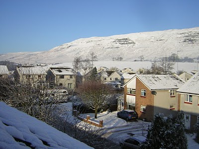
Snowfall returned here to my Lennoxtown home in late January as well as in February and even March. Lying for over 5 days at a time, a longer duration than most winter’s in my 27-year lifetime. It even snowed in May and the snow remained (patchy) on the Camspie Fells (the hills just north of my house, you can see them in both photos below) until May 11th. In fact there was at least patches of snow lying on these hills, less than 1,000 feet in elevation PERMANENTLY from Dec 18th, through May 11…. My neighbour said, he’s never seen snow lie on them as long nor as late into spring.
Then winter of 2010-11 arrived fast and furious. The snows arrived and accummulated to a respectible 5 inches by the evening of November 28th. Of course it’s now December 26th and there’s still snow on the ground as I write this. Two days from now and the snow will have lay PERMANENTLY for 1 full calender month. Beating last winter’s snowcover duration by a full week. In between this cold and snowy period in which the first 10 day period of this cold spell, we saw near 1-2 inches of fresh snow accummulate day after day, appearing to always snarl and nearly bring the morning rush hour in Glasgow to a standstill. Indeed it did on a few occations. Greatest snowdepths topped 8.5 inches in my back garden whilst outlying areas saw over a foot. Areas around Edinburgh topped 30+ inches, with more over the higher ground in the Lothiansd and Borders as well as over Northumberland, Yorkshire, Durham and to the north over the Central and Northern Scottish Highlands. Temperatures persistently dropped to between -15 and -20C over the southern, central and north Highlands and during the later half of this coldwave, the Midlands of England as well as Yorkshire saw lows persistently fall to between -16 and -20C with Pershore, Shropshire besting last year’s coldest in England. Last winter: -18C both Woodford (Greater Manchester) and Benson (Oxfordshire), this year: -19.6C at Pershore (Shropshire). Northern Ireland of course saw records tumble left right and centre (see above). Indeed lows this year beat those of last year in the Central Lowlands of Scotland with Edinburgh falling to a remarkable -16C whilst Glasgow dipped to -13C. Outlying subrubs of both cities fell to between -16C and -18C. Cold daytime highs smashed the lowest values last year with -15.8C recorded for a daytime maximum at Altnaharra, only .1C off the lowest daytime maximum ever recorded in the UK, The day before saw a maximum of only -14C at Altnaharra and these frigid highs we’re reached after several nights which plunged to -20C. Last winter’s coldest high was -12C at Braemar.
Christmas Day 2009
Christmas Day 2010

Vagaries of the Weather
India & Sub-Continental Asia Weather
By Rajesh Kapadia
Coming Soon!
What’s Reaching Today’s Blogs?
Coming Soon!
Today’s Extremes here at my house
High: 34 degrees
Low: 16 degrees
Snowcover: 1 inch
Thanks for reading.
-Mark


>Fife Report
Cars showing dashboard temperatures of 3-5 deg C drive with window-wipers on low to clear windscreens of slight rain. Those inside the cars begin to see the snow disappear and Spring roll in.
>Thankyou! I appreciate the encouraging words. Hope you had a great Christmas.
>Great post,I so much love this post. thank you much for uploading it.
Your blog is so informative ? keep up the good work!!!!