
I know I said in this morning’s video that I wasn’t going to post today but there are a couple of quick points I wanted to cover.
Firstly, following yesterday’s pretty persistent sleet and snow (rain for some) streaming in on a stiff, cold east wind, we saw Braemar sink to -14.1C. Coldest in the UK so far this winter. I recon we may exceed that number tomorrow morning providing temps hold firmly below freezing this afternoon, winds are light and skies clear.
Today is bright and crisp for many but in the fresh to strong ENE wind, EASTERN/HIGHLAND Scotland and NE England are seeing frequent sleet and snow showers through today which transfer south down eastern England tonight.
[s2If current_user_can(access_s2member_level1)]

Credit: BBC Weather

Credit: AccuWeather Pro
Winds blow in many from the ENE today and then turn from NNE this evening.

Credit: AccuWeather Pro

Credit: AccuWeather Pro
Expect some tricky travel in places!
That’s why there’s a yellow be aware warning issued by the MO.
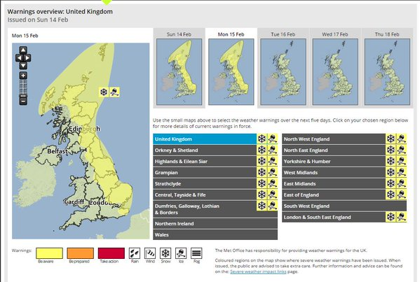
Credit: Met Office
It’s a chilly early afternoon, especially over Aonach Mor and Great Dun Fell.

Credit: Meteoceil
Brisk winds are making it feel bitter over the North Pennines just now.

Tonight, away from the east expect a widespread hard frost to form quickly after sun down.

Credit: BBC Weather
Most major towns and cities shall dip to freezing. Rural areas of central England/Wales northward -4 to -8C. Some snow covered Highland Glens may approach -15 or -16C.
More on the upcoming week in today’s video and in tomorrow morning’s write-up.
[/s2If][s2If current_user_cannot(access_s2member_level1)][magicactionbox id=”18716″][/s2If]


Recent Comments