>
Join The Conversation!
In Today’s Blog
Latest UK-Europe Discussion @ #UK-EUROPE
Powerhouse Low Kicks NE Allowing High Pressure To Dominate Next 48 Hours Before Next System Arrive Thurs, Cool, Unsettled Across Much Of Europe
EUROPE LATEST
WILD WEATHER ACROSS SCOTLAND WHILE ENGLAND/WALES ENJOY SUNSHINE
101mm Of Rain Brings Wettest May Day On Record To Kinlochewe While An 81 mph Wind Gust Is Recorded At The Tay Road Bridge On Sunday

Yesterday was a day of dramatic contrast between beautiful mild, sunny weather which dominated much of the central and southern UK thanks to high pressure while a rapidly deepening low tracking east, just south of Iceland brought a strong and slow moving frontal boundary down across Scotland.
SEA LEVEL WINDS OVER THE TAY ESTUARY WERE CLOCKED AT 81 MPH
This very tightly wound system sharpend the pressure gradient north to south over Scotland, bringing unseasonably strong winds everywhere. While the Central Lowlands endured 40-60 mph winds, just a little further north, yet even at sea level across the southern Highlands, winds were dramatically stronger with southwest winds racing through the Firth of Tay clocking 81 mph at one stage, Winds stacked vertically up through the atmosphere can support a downward transfer of powerful upper level winds, meaning hurricane-force winds generally above a few thousands feet can transfer downwards.
WINDS ABOVE 4,000 FEET ON MOUNTAIN TOPS CLOCKED OVER 100 MPH WINDS
With height, winds grew in strength with Aonach Mor, located just east of Ben Nevis and at an elev of 4,006 feet recorded a gust to at least 108 mph yestereday morning.
The fact that the surface and upper high were close by, this intensified the overall storm system, fuelled by extreme heat over Spain and warmth throughout much of the North Atlantic Ocean, combined with very cold air both north of the system over Greenland and the Arctic Ocean off NW Norway and in the upper levels being fed into the low. This setup of huge thermal contrasts create super strong jet streams and this harnesses the atmospheres ability to bungle this energy into rapidly deepening low pressure systems.
The powerful winds over Scotland were greatly helped by the pressure difference between the high over Spain and extending north up into England and the sharply lowering pressures over Scotland with maximum depth within the storm itself north of Scotland.
THINK THE WINDS WERE IMPRESSIVE, SO TOO WERE THE RAINS!

Not only was the winds impressive but so too was the rains. Kinlochewe tallied an impressive 101mm within 24 hours, this breaks the May record for wettest day here. While down here in the western Central Belt we saw tremendously heavy and persistent rain, particularly after 3pm into early evening, the mountains of western and northwestern Scotland aids in forcing deep moist flows of air upwards which further cools and condenses the air as it flows up the windward slopes of the hills and this then enhances the rainfall.

A front moving very slowly south-eastwards across Scotland on Sunday brought some persistently heavy rain to western areas, where orographic uplift over the NW Highlands enhanced the rainfall.
Kinlochewe, at the head of a steep-sided valley that faces southwest, recorded 88mm of rain in just 12 hours. However, in the ‘rain shadow’ in the lee of the Highlands there was hardly any rain.
These images (above) of 12-hour accumulated rainfall radar (left) and 12-hour measured rainfall amounts in mm (right) up to 18:00 UTC illustrate the stark contrast. (Courtesy of MeteoGroup)
CRAZY TURNAROUND: Sarajevo, Bosnia-Herzegovina goes from mid-80s Saturday to heavy snow Monday!
Summer to Snow in Sarajevo!
ACCUWEATHER
ASIA LATEST
Flash Floods & Freak Hailstorms Kill 40, Injure 87 Across Gansu Province Of NW China
Flash floods hit northwest China
BBC
US LATEST
Big East Coast Rains Setting Up This Week
FOR FREQUENT US WEATHER UPDATES, CHECK OUT THE FACEBOOK PAGE AND LIKE IT!

VIDEO: I-95 Soaker, DC to Philly to NYC
ACCUWEATHER
Wet Weather Expands From Southeast to Mid-Atlantic
ACCUWEATHER

Texas, New Mexico Drought Relief Comes at a Price
ACCUWEATHER
AUSTRALIA LATEST
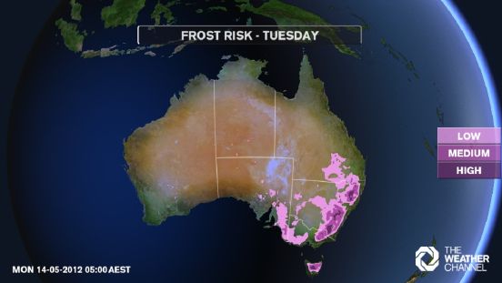
Following Weekend Snows Over Tasmania, Victorian Alps, Clear Skies, Light Winds Bring Severe Inland Frosts, Canberra Hits -5C
Hail the size of golf balls wreaks damage in south
THE WEATHER CHANNEL (AUS)
Canberra freezes: overnight temps drop to -5˚C
THE WEATHER CHANNEL (AUS)
Sydney dry spell nearing record territory
THE WEATHER CHANNEL (AUS)
THE EXTREMES OF THE DAY
TODAY’S US EXTREMES
COURTESY OF ACCUWEATHER
HIGH: 112° at Death Valley, CA
LOW: 20° at Dillon, CO
TODAY’S UK EXTREMES
COURTESY OF THE MET OFFICE
HIGH: 62° (16.7°C) at Donna Nook (Lincolnshire)
LOW: 35° (1.6°C) at Warcop (Cumbria)
TODAY’S EXTREMES HERE AT MY HOUSE
HIGH: 54°
LOW: 40°
Thanks for reading.
-Mark


Recent Comments