>
Join The Conversation!
In Today’s Blog
Latest UK-Europe Discussion @ #UK-EUROPE
Get Ready UK! We’re ALL In For Heavy Overnight Rains As Next Atlantic Low Sweeps In
EUROPE LATEST
Get Ready UK! We’re ALL In For Heavy Overnight Rains As Next Atlantic Low Sweeps In
HEAVY SNOW AND BLIZZARD CONDITIONS TO AFFECT HIGHLANDS AND GRAMPIANS OVER NEXT 24 HOURS

The next Atlantic storm system arrives out of the southwest tonight, Set to bring an all-night heavy rain throughout England/Wales, staying mild as warmth bleeds north from France.
AN ALL-NIGHT HEAVY RAIN FOR MUCH OF ENGLAND AND WALES
Get ready for an all-night heavy, persistent rain which will cause poor visibility on the roads and will cause flooding in areas, especially areas already saturated from recent rains.
Into the late evening, while heavy rains persistent throughout the South, the canopy of rain pushes up through the North of England and eventually into Southern Scotland.
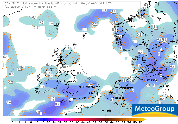
While a solid inch and in some spots, 2 inches may fall across parts of England and Wales as well as eastern Ireland, winds are going to pick up out of the southwest from the Southwest coast up through the Midlands while a cold, raw easterly wind will pick up across the North of England and eventually Scotland later this evening, making the situation seen even more bleak.
While heavy rains persistent throughout the night across England and Wales I think late tonight, perhaps nearer 11pm, the area of rain will push into Dumfries and Galloway and the Borders and by the early hours, the Central Belt will get in on this heavy rain which should cause plenty of headaches for the Thursday morning rush.
By Thursday morning’s rush hour from Southhampton to Birmingham, the bulk of the rain should have lifted north and by mid morning have cleared Manchester and Liverpool with bright spells possibly poking through across the southernmost counties.
SOUTHERN AND CENTRAL UK SHOULD SEE CLEARING THROUGH THURSDAY AM WHILE RAINS PERSISTENT ALL DAY ACROSS SCOTLAND
Scotland looks to see a nasty day tomorrow with persistent and heavy rain accompanied by a stiff easterly wind which should make the 5 or 7C temp feel closer to 1 or 2C.
The warmth over Spain and France is partly fuelling the heavy and persistent rains that will affect the UK tonight as this warm air will get pulled north into the rain canopy and help further destabalize the atmosphere, forcing stronger upward motion and therefore enhancing the rains in places. In the heaviest pulses, don’t be surprised to see some thunder and lightning along with very gusty winds. Though a tornado is not likely, it can’t be ruled out during the day tomorrow as the low becomes elongated and the level of upward motion increases beneath of the low pressure centre when sunshine gets involved. Like we saw the other day over parts of the Midlands and Oxfordshire, winds blowing at different direction with height means any storm cells which forms within the largescale area of upward motion and if sun gets involved, can set the correct envirtonment for funnel cloud and tornadoes to develop. Read More!
US LATEST
Another Wet Day Up The East Coast, Strong Storms Possible Over Carolinas, More Rain For Texas

Gusty Storms with Beneficial Rain Aim for Southeast Coast
ACCUWEATHER

VIDEO: Still Unsettled in East
ACCUWEATHER
Strong Storms, Beneficial Rainfall for East Coast Wednesday
ACCUWEATHER
Severe Storm, Flood Threat in Drought-Stricken Parts of Texas
ACCUWEATHER
Feet of Floodwaters Inundate Alabama
THE WEATHER CHANNEL
ASIA LATEST
Stormy Day Across Japan, Keeping Eye On Invest 99W
Flooding And Mudslides Kills 3 In Eastern Indonesia
WESTERNPACIFICWEATHER
FOLLOWING WESTERNPACIFICWEATHER.COM
AUSTRALIA LATEST
Quiet And Warm Weather Dominates Australia But Changes Loom For SE In Coming Days
9 May, 2012: Whitaker’s Weather Summary
Sydney Catches Up Following Poor Summer With Warmest May In Years
Sydney Bathes In Rare May Warmth
THE WEATHER CHANNEL (AUS)
THE EXTREMES OF THE DAY
TODAY’S US EXTREMES
COURTESY OF ACCUWEATHER
HIGH: 110° at Death Valley, CA
LOW: 20° at Bodie State Park, CA
TODAY’S UK EXTREMES
COURTESY OF THE MET OFFICE
HIGH: 63° (17.2°C) at Manston (Kent)
LOW: 25° (-4°C) at Aboyne (Aberdeenshire)
TODAY’S EXTREMES HERE AT MY HOUSE
HIGH: 54°
LOW: 33°
Thanks for reading.
-Mark


Recent Comments