>
Join The Conversation!
In Today’s Blog
Latest US Discussion @ #USA
US LATEST DISCUSSION: Severe Weather Threatens Southern Plains Today Into Tonight While Denver Goes From Record 84 Yesterday To Snowstorm Tonight
UK-Europe Summer 2012 Forecast @ #SEASONAL FORECASTS
Dry spring could lead to a significantly warm June, July over England which periodically extends up into Scotland and west into Ireland
Your Weather Headlines Today
EUROPE LATEST
From Shades, Shorts & Sunscreen Of Last Week To Snow, Shovelling & Bundling Up!
UPDATE: Heavy snow is falling tonight across the northern and central Highlands into Grampian and this will continue working southward through tonight along with the cold front. By morning rain should have turned to snow over Perthshire, Angus, Tayside, Fife, the Borders westwards over to the higher parts of Lanarkshire, Dumfries & Galloway
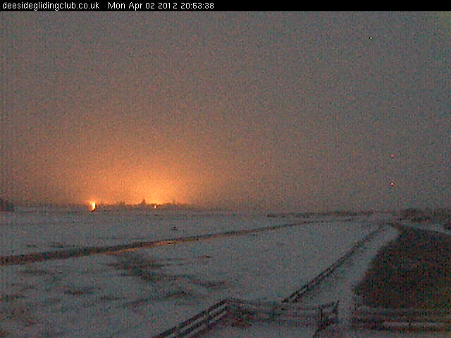
While the western Central Belt at LOW LEVELS will likely remain wet (but snow is likely to be falling), you may only have to climb a little in elevation into Ayrshire or South Lanarkshire to see lying snow in the morning. Watch for icy patches developing fast as temps drop towards 1 or 2C by dawn. Wind blowing strong out of the northeast will make it feel very cold at -2 to -7C.
ORIGINAL WRITE-UP.
A southbound cold front will drag cold, late season arctic air down across the UK and Ireland over the next 12-24 hours with sharp temperature falls through tonight. This fall in temperature at the same time the moist front sweeps through means we will see rain change quickly to snow in areas.
We’re already seeing heavy snow fall across Caithness, Sutherland into the Central Highlands, Aberdeenshire and this will continue spreading south through this evening as the cold front pushes through Central Scotland. It will be eastern areas, particularly those exposed to the cold northeast wind which will see it snow and accumulate. Areas likely to see difficult dricing conditions tonight will be Angus, Tayside, Fife, through Greater Edinburgh, Borders and by tomorrow morning, Northumberland, Tyneside including Newcastle and possibly Yorkshire. With the focus of precipitation aimed at eastern areas, western areas, though may see hill snow, won’t get much low elevation snow.
Subscribe To My YouTube Channel
I believe areas generally WEST of Harthill and Shotts in the M8 corridor won’t see much snow and you’ll have to go into the higher parts of N and S Lanarkshire, Ayrshire and Dumfries and Galloway to find lying snow. Watch out on the M74 as it climbs from Blackwood and Lesmahagow southward, it may be tricky with a covering of snow and ice between Happendon services and Beattock Summit where it can often be nasty.
The A9 will likely be bad as will the A90 between Perth and Aberdeen. Watch out on the Trans-Peninne routes such as the A69, A66 and the A1 from North Berwick down the east of England.
US LATEST
Powerful Thunderstorms Take Aim At Southern Plains, Arkatex Today
Subscribe To My YouTube Channel
Powerful Storms Target Portions of the South
ACCUWEATHER
Over 80 Cities Spanning 25 States Break Record Warmest March Ever
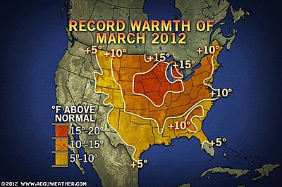
Warmest March Ever for Cities in More Than 25 States
ACCUWEATHER
Warmest March on Record in Dozens of Cities
THE WEATHER CHANNEL
Rainfall Records Set in Oregon
ACCUWEATHER
ASIA LATEST
Tropical Storm Whips Vietnam
Tropical Storm Pakhar Whips Southern Vietnam
ACCUWEATHER
AUSTRALIA LATEST
Settled, Warm Across Australia With Alice Springs Eyeing Warm,est April Temps On Record
THE EXTREMES OF THE DAY
TODAY’S US EXTREMES
COURTESY OF ACCUWEATHER
HIGH: 99° at Laredo, TX
LOW: 2° at Stanley, ID
TODAY’S EXTREMES HERE AT MY HOUSE
HIGH: 54°
LOW: 46°
Thanks for reading.
-Mark


>Thanks for the weather update it seems to be useful and helpful for us. learn more about adelaide weather here