>
Join The Conversation!
My Official Summer 2012 Forecast Will Be Available On 31 March, 2012

It has saddened me deeply of Ken’s passing. I loved his tremendous personality as well as humor and great back and forth banter with Bernie on Point Counterpoint, I have also loved learning from Ken over my years of studying my particular passion for US weather.. It was an honor to meet Ken in January 2009.
Today’s Global Weather Headlines
Europe Latest
Scotland Experiences Outstanding Streak Of 3 All-Time Record Highs For March 2012
Old Record: 22.2C recorded at Gordon Castle in 1957, Sunday’s new record: 22.8C at Fyvie Castle, Monday’s new record 23.2C at Cromdale, today’s new record: at least 23.6C at Aboyne!

A sunny, warm Glasgow looking west down the Clyde early this afternoon (courtesy of Mark Vogan)
I thought last week and the previous week had been remarkable across the USA and Canada with all their off the charts record breaking warmth but if I am being honest, although I did forecast some very impressive warmth, settled and strongly high pressure dominated weather over the UK and Ireland, I guess I didn’t see a three day stretch in which each day would see an all-time Scotland record fall.
Although not just as extreme of the US in terms of margin from old record to new record, in my opinion, it is harder for us to see this type of record-breaking weather than in the US simply because we don’t typically get EXTREMES here due to various reasons. However, the tell tale signs have been with us since early last December when we were basically the stormiest place or one of the stormiest places on the planet with every other day seeing severe gale-force winds, torrential rains and damage. On Christmas day, Northern Ireland saw it’s warmest Christmas on record while Scotland and the UK fell shy by less than 1C. We also fell just shy of the February record for Scotland by less than 1C, but this month, mother nature says, ya know what, I think it’s time to set a record and not once, not twice but three times!

Rare image capturing a cloudfree UK & Ireland at midday today, courtesy of the MODIS satellite. Thanks to my twitter follower @Mark_Dunphy for sharing this.
High pressure has been dominated and this continues to raise concerns for this summer. I blame the drought stretching from Spain to the Midlands of England on keeping us generally warm and settled. This persistency in high pressure dominance has eventually paid off in terms of record warmth. This returning surge of high pressure has grown stronger and with a position directly overhead and combined with correct wind direction, has meant temps have soared.

Wednesday looks to be another very warm one with very sunny skies and temps widely 17-22C with a few spots from Southern Scotland to London taking a run at 23 or 24C. Thursday will see a slow breaking down of the strong upper heights and this means the return of clouds, light rain and cooler temps. By this weekend, after another warm day Thursday across central and southern England, a return to nearer normal will come with a chilly NW flow and potential hill snow.
March temperature records broken again in Scotland
BBC
Scots sweltering in third day of record-breaking sunshine
STV NEWS
Galloway hillside grass fire continues to rage
BBC
US Latest
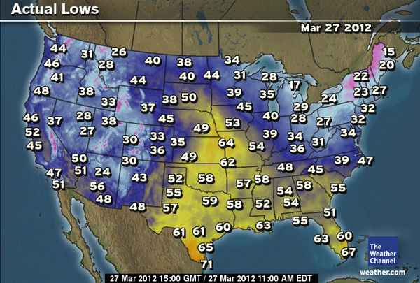
Cold Start For Northeast, A Real Shock After Record 70s, 80s. Severe Weather Threatens Mid-Section Tonight
Severe Storm Threat This Evening Near St. Louis, Chicago
ACCUWEATHER

VIDEO: Warmup Coming to the East
ACCUWEATHER
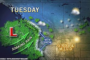
Dreary Week in Store for the Northwest
ACCUWEATHER
Australia Latest
Exceptional Rains Fall Yet Again Across Queensland!
THE EXTREMES OF THE DAY
TODAY’S US EXTREMES
COURTESY OF ACCUWEATHER
HIGH: 91° at Dryden, TX
LOW: 10° at Frenchville, ME
TODAY’S UK EXTREMES
COURTESY OF THE MET OFFICE
HIGH: 74° (23.6°C) at Aboyne (Aberdeenshire)
LOW: 26° (-3.6°C) at Altnaharra (Sutherland)
TODAY’S EXTREMES HERE AT MY HOUSE
HIGH: 67°
LOW: 31°
Thanks for reading.
-Mark


Recent Comments