>
Join The Conversation!
My Official Summer 2012 Forecast Will Be Available On 31 March, 2012
Severe Thunderstorm Watches In Effect For SE West Virginia, SW Virginia, Cent N & S Carolina, SE Georgia, N Florida!
Today’s Global Weather Headlines
Europe Latest
Summer-like Pattern To Last Throughout This Week, Scotland May Threaten March Heat Record Sunday
Temps climbed to 18C at Prestwick, Ayrshire

There is little change in my overall thoughts for the upcoming 4-6 days over the UK and Ireland as high pressure will continue to build in from the south. What appears to be more apparent this evening is that sunshine could be more than I first thought and therefore I am more confident in calling the forecast highs I have orginally pointed to over the past several days.
So, long and short of it, what we’re gonna see day after day through at least Wednesday is fog, low cloud and mist formation once the sun falls below the horizon each night. This fog, like we’ve already seen will be extensive and will spread generally east to west with the light onshore flow off the North Sea. By daytime, once the sun rises we see for most, a fairly quick burn off and peeling back of this canopy back towards the North Sea coastal areas of England and Scotland. In inland areas open and exposed to the sea, we may find fog moves in during the day as increasing sea breezes kick in as the land heats up.
Elsewhere and away from the coast and fog we are talking sunshine in abundance and temps rising tomorrow into the 16-20C range widely. Parts of South-Central England, Greater London up through the Midlands and perhaps as far north as Yorkshire, we may see several 22-24C readings Sunday through Wednesday. The Central Belt of Scotland should warm into the 16-19C range IF there is no cloud or fog into the afternoon hours Sunday through at least Tuesday. Sheltered parts of Dumfries and Galloway, the Borders up through the Highlands and Aberdeenshire to the lee of the Grampians may see pockets of 21-23C tomorrow through Tuesday, perhaps Wednesday.
22.2C is the reading we are keeping a close eye on over the upcoming few days. If we exceed that in Scotland then we will have set a new heat record for the March in Scotland, I believe this is possible, I also believe that 24C is very possible somewhere over England and eastern Wales over the next 7 days before the ridge gradually breaks down and there may even be a 25C high somewhere.

Spring has sprung, in record warmth
VIEWS AND NEWS FROM NORWAY
US Latest
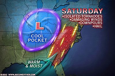
Heat Eases As Strong To Severe Storms Focus On East Today
Severe Thunderstorm Watches In Effect For SE West Virginia, SW Virginia, Cent N & S Carolina, SE Georgia, N Florida!
As of 4:00 p.m. EDT, a broken line of violent thunderstorms extended from southwestern Virginia to central South Carolina. Several powerful thunderstorms were preceding this line across eastern parts of the Carolinas.
The line was bearing down on the Charlotte, N.C., area and was tracking toward Winston-Salem, N.C., and Roanoke, Va.
One supercell within this line has prompted a tornado warning south of Roanoke, Va.
The violent thunderstorms in southwestern Virginia have also had a history of producing baseball-sized hail, which broke windows of a home at Groundhog Mountain along the Blue Ridge Parkway.
In South Carolina, quarter-sized hail covered the ground of some homes near Salley. (AccuWeather)
Location in Suwannee Co, Florida picked up 2″ of rain in 12 mins according to @adrien_veilleux
Numerous Violent Storms Striking the Southeast
ACCUWEATHER
LATEST VIDEO: Southeast Storms
ACCUWEATHER
Severe Weather Now Rattling the Southeast
ACCUWEATHER
Heavy Rains Finally on the Exit
THE WEATHER PROFESSOR
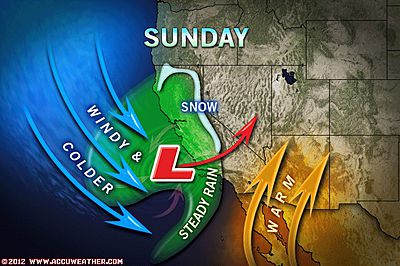
Weekend California Storm with Rain, Mountain Snow Looms
ACCUWEATHER
Wild Ride On I-74 in Shelbyville, Indiana Last Last!

Hawaii’s Largest Hailstone Ever Recorded Is Confirmed!
.jpg)
Hawaii’s Largest Hailstone Ever Has Been Confirmed
ACCUWEATHER
Looking Back At The Great Heat Wave of March 2012
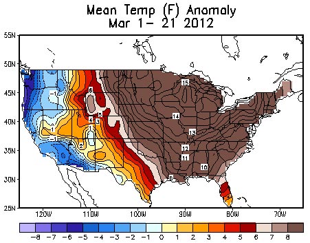
Amazing Stats from the March 2012 ‘Heat Wave’
ACCUWEATHER
Perspective: More than 6,000 Record Highs Set!
THE WEATHER CHANNEL
The March 2012 Heat Wave Has Been Exceptional By Why?
FIRSTHAND WEATHER
Canada Latest
Extreme March Heat Eases, Returning To Nearer Normal Again
The cooldown coming to Eastern Canada will be a shock given just how warm it’s been of late. Snow is expected across Northern Ontario today!
Summer like weather leaving Ontario
THE WEATHER NETWORK

Australia Latest
Cold In SE While Rest Of Country A Lot Quieter Than Of Late
The cold weather has certainly arrived down in New South Wales, Aus with Young Ap reported a 15 year March min of 1.8C.
As for arid Western Australia, the 71.2mm which fell as of 9am today at Fitzroy Crossing Airport was biggest rains in 3 months there.
THE EXTREMES OF THE DAY
TODAY’S US EXTREMES
COURTESY OF ACCUWEATHER
HIGH: 94° at Laredo, TX
LOW: 7° at St Mary, MT
TODAY’S UK EXTREMES
COURTESY OF THE MET OFFICE
HIGH: 72° (22.2°C) at Porthmadog
LOW: 31° (-0.6°C) at Exeter Airport (Devon)
TODAY’S EXTREMES HERE AT MY HOUSE
HIGH: 57°
LOW: 39°
Thanks for reading.
-Mark


Recent Comments