>
Join The Conversation!
WRITE-UP: Azores High Set To Return, May Bring Warmest February Temp On Record To UK By Tuesday/Wednesday (See Below)
I am currently in the process of producing a video which includes the best winter photos by my Facebook fans. If you have any winter photo’s, be sure to upload them to the Facebook page and they will be included in the video along with your name and your town/country. Should be ready for release by late March/early April 2012
Today’s Global Weather Headlines
US Latest
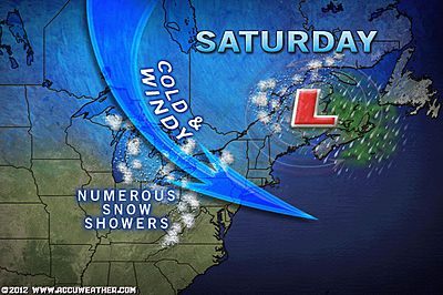
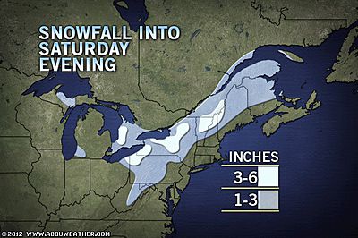
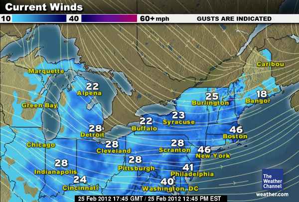
Winds To Howl Through Northeast, Mid-Atlantic Today With Heavy Snow Downwind of Lakes And Across New England
Below is a list of peak wind gusts through Saturday afternoon:
Allentown, Pa.: 46 MPH
Lancaster, Pa.: 51 MPH
New York (La Guardia), N.Y.: 47 MPH
BWI Airport: 48 MPH
Boston, Mass.: 54 MPH
Worchester, Mass.: 58 MPH
Rchester, N.Y.: 52 MPH
Altoona, Pa.: 45 MPH
Stats Courtesy of AccuWeather.com
NEW: Winds, Snow Squalls Lead to Massive Pile-Up on I-79
ACCUWEATHER.COM
VIDEO: Very Heavy Snow Squalls
ACCUWEATHER.COM
High Winds to Howl in the Northeast, Disrupt Travel
ACCUWEATHER.COM
Lake-Effect Snow Thump for Great Lakes, Northeast
ACCUWEATHER.COM
Wrap-up of Friday’s Severe Storms
ACCUWEATHER.COM
Significant Return Of Winter To Northern Plains?

Double Whammy: Two Northern Plains Snows on the Way
ACCUWEATHER.COM
Severe Weather Threatens Monday & Tuesday Night Again!
Early Week Severe Storms to Take Aim on Mississippi Valley
ACCUWEATHER.COM

Canada Latest
Major Snowstorm Sweeps Across Atlantic Canada

Eastern Canada Snowstorm
ACCUWEATHER.COM
Snow piles up in Ontario
THE WEATHER NETWORK
What Happened To The Big Snow In Toronto?
Europe Latest
Cooler Air To Be Short Lived As Azores High Rebuilds Into UK Fast Next Week
‘TODAY’S FACEBOOK FORECAST’
Azores High Set To Return, May Bring Warmest February Temp On Record To UK By Tuesday/Wednesday
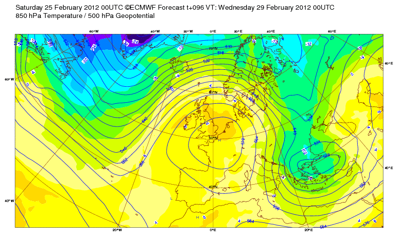
While temps have cooled this weekend following the balmy readings of late last week as the ridge gets squashed, it appears the models haven’t let go of the warm theme for the UK just yet. Over the last couple of days they have persistently shown the return of the ridge back up into the UK by Tuesday and I am wondering whether ‘heights’ or thickness values may be slightly stronger than what we saw last week. What does this mean? Well, it could suggest that if this were to be true, the overall warmth of this bubble of circulating air may be greater.

An important thing to look at is the position of the high pressure centre as this can be important in determining the direction in which the wind blows over the UK. Incidentally, the centre shows to be positioned just south, east of London and this, given the size of the high brings winds widely across England out of the southwest, similar to last Thursday when the high topped 18C in several areas.
So, given adequate sunshine as well as possible downsloping off hills and of course the ongoing drier than normal soils, this points to yet another day or two of late April/early May conditions. Right now, I am shooting for a widespread 14-17C across England with a potential pocket of 17-20C. A reading of 20C by the end of Wednesday which I believe would be the best day of seeing such a temp reading would make for the warmest February day in UK history, besting the 19.7C high set at Greenwich in 1988.
Australia Latest
THE EXTREMES OF THE DAY
TODAY’S US EXTREMES
COURTESY OF ACCUWEATHER
HIGH: 87° at Opa Locka, FL
LOW: -10° at Pinedale, WY
TODAY’S UK EXTREMES
COURTESY OF THE MET OFFICE
HIGH: 56° (13.5°C) at Cardiff Bute Park
LOW: 28° (-2.2°C) at Santon Downham (Suffolk)
TODAY’S EXTREMES HERE AT MY HOUSE
HIGH: 47°
LOW: 39°
Thanks for reading.
-Mark


Recent Comments