>
VOGAN’S VIEWS ON EUROPE VIDEO IS NOW AVAILABLE BELOW
Today’s Global Weather Headlines
Europe Latest
Cold Front Sweeps South Over Scotland Tonight, Heavy Rains Quickly Change To Snow As Temps Drop Fast & Ice Risk Increases
FACEBOOK:

LIVE FACEBOOK COMMENTS:
( I. M. Sirota, S. New Jersey) Sunny and gorgeous here in southern New Jersey, with a high earlier this afternoon of about 13 degrees Celsius!
(K. Blong, Lancaster) been drizzly all day, and is still overcast here in lancaster, not too cold tho
(J. Williamson) raining still here in cumbria
(P. Whitman, Aviemore) Aviemore 3 degrees raining.
(T. O’Reilly Bowles, Dublin) damp drizzly and a bit windy at the mo in Dublin
( J. Clark, Plymouth) Quite mild here in Plymouth, about 9 degrees and cloudy. Winds has slowly been picking up throughout the day too.
(C. Greene, NW Ireland) getting windy here in north-west ireland and cold at 10c but real feel is 3c
(S. McCormick, Belfast) Cold and windy
(S. O Farrell, Wexford) very windy
(C. Snell, Berkshire) Dry, warm and windy in Berkshire
(R. Deakin, Uddingston, N. Lanarkshire) the wind starting to get stronger the rains stopped the now but not for long
(M. Vogan, Lennoxtown, E. Dumbartonshire) Turning very windy along with rain here across C. Scotland
Over the course of tonight winds will increase as rains turn heavy across Scotland as we find ourselves underneath the meeting point between a mild, maritime air mass and cold, arctic air mass. These two fight it out and can often bring, nasty, dangerous, rapidly changing weather. As the front nears, west winds will blow hard and rains will be heavy, once this front pushes off to your south, you’ll notice a temperature drop from perhaps 6 or 7C down to 2 or 3C and those rains will turn sleety if not quickly to snow.
The concern I have is that those heavy rains may turn very quickly to heavy snow, especially over the Highlands and with strong to gale-force winds veering northwesterly, wind chills drop like a stone and blizzard conditions set in.
Central Belt Snow? It Depends On Speed of Cold Front & Whether Precipitation Band Weakens!
As for the Central Belt, there are several questions which must be considered with this scenario. 1) The speed of the cold front and 2) how much weakening of the precipitation band will there be once this front reaches the central belt. Also, 3) what depth within the atmosphere is the cold air and just how cold are we talking?
For tonight, my uncertainty lies with the timing of this cold front and whether it will slow down as it heads out of the Highlands and into the Lowlands. The slower the cold front sweeps south, then 1) it will mean the cold doesn’t arrive until tomorrow morning, 2) it also would suggest less chance of snow as rains could well peter out and ultimately, we would see clearing skies and dropping temps and yet more dissapointment to snow lovers living in the Glasgow-Edinburgh corridor.
What I believe will happen is the cold front will push through the Highlands through late tonight turning rain over to heavy snow and temps drop fast while strong westerly winds turn northwesterly, drawing down that arctic air, feeding those heavy snows which could cause big problems over the Highlands tonight with blizzard conditions, even over the A9 firstly between Inverness-Aviemore and then Aviemore to perhaps Pitlochry.
During the early morning hours, I think the cold front enters the Central Belt where it’s been raining a good part of the night. The front pushes through, turns winds northwesterly and rains turn rapidly to snow over the hills surrounding the M8 corridor, Ayrshire & Galloway hills and as the cold air becomes more firmly established with sleet reaching the surface at low levels, snow will begin and bring a covering.
US Latest
So, Is This Weekend’s Much Anticipated Storm Just Hype Or Something To Get Excited About?
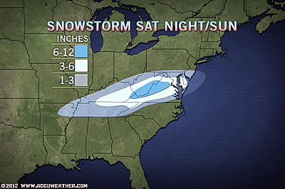
Main Corridor Of Snow Stretches From Kentucky Through West Virginia, central Virginia, Maryland To Cape May, NJ. 12-16″ possible from KY to Mtns of Western VA, 3-6 across DC, Baltimore, Cape May, Atlantic City, NJ. PHL to NYC may pick up 1-3.
GREATEST SEVERE WEATHER RISK AREA: I-10 FROM NEW ORLEANS TO TALLAHASSEE
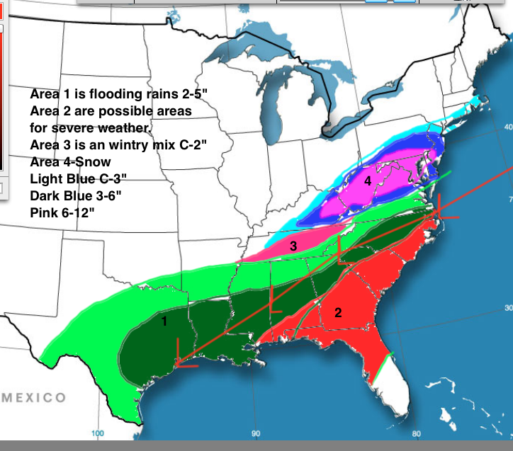
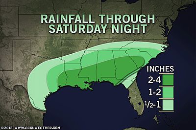
A major storm system, currently over northwest Mexico will push east, northeast across the Southern tier bringing a significant rain and possibly severe weather event from Texas to Georgia while snowfall will occur from Memphis to New York City.
At this time, the concern over severe thunderstorm development focuses along the I-10 corridor from New Orleans to Tallahassee as a powerful low level jet and southerly flow to the south of a warm front draws warm, moist air north off the Gulf of Mexico. Tornadoes are possible Sat and Sat night while widespread 2-4″ inch rains are possible across the majority of Louisiana, Mississippi, Alabama into Georgia. It appears the rain-snow line will be just north into Tennessee.
Interestingly, from New York City northwards, there will be hardly any snow from this.
Severe Weather To Impact Corridor From New Orleans To Tallahassee On Saturday!

Significant Rain Event Shaping Up Across South While Heavy Snows Break Out To The North This Weekend
Weekend Storm Related Stories
Violent Storms to Hit New Orleans to Tallahassee Saturday
ACCUWEATHER.COM
Weekend Snowstorm to Target Ohio Valley First
ACCUWEATHER.COM
Mid-Atlantic Snowstorm Targeting DC, Baltimore Sunday
ACCUWEATHER.COM
Good Rain, Bad Rain for the South
ACCUWEATHER.COM
Canada Latest
NEW: Another Atlantic Canada Weekend Snowstorm
ACCUWEATHER.COM

Ontarians battled icy roads Thursday
THE WEATHER NETWORK
Record rainfall hits Newfoundland
THE WEATHER NETWORK
Mild weather shuts Rideau Canal
THE WEATHER NETWORK
Australia Latest
Very Stormy Across Southeast Australia With Severe Storms Warnings For Areas
THE EXTREMES OF THE DAY
TODAY’S US EXTREMES
COURTESY OF ACCUWEATHER
HIGH: 84° at Miami, FL
LOW: -3° at Leadville, CO
TODAY’S UK EXTREMES
COURTESY OF THE MET OFFICE
HIGH: 56° (13.1°C) at Murlough (Down)
LOW: 29° (-1.6°C) at Aboyne (Aberdeenshire)
TODAY’S EXTREMES HERE AT MY HOUSE
HIGH: 49°
LOW: 38°
Thanks for reading.
-Mark


>Hi , I will be happy if you visit my blog :
http://weather2222.blogspot.com/
>hi i wii be happy if you come and see my blog
http://weather2222.blogspot.com/