>
Join The Conversation!
LONG RANGE VIDEO NOW AVAILABLE BELOW!
Today’s Global Weather Headlines
Europe Latest
Stunning Coldwave Continues, Extends Some 2,500 miles!

VIDEO: Next Storm Targets Rome
ACCUWEATHER.COM
Big freeze continues to grip Europe
BBC
Europe’s Cold Will Last for Weeks
ACCUWEATHER.COM
Most Ukraine cold deaths alcohol-related, minister says
CNN

Freezing Rain Possible Tonight For Scotland/Northern England While Disruptive Snow Looms From Yorkshire Southwards Thurs Night
SIGNIFICANT ICE RISK FOR MUCH OF SCOTLAND, NORTH OF ENGLAND TONIGHT /THURS AS RAIN FALLS ONTO BELOW FREEZING SURFACES

With an Atlantic frontal system trying to work it’s way east, it has little trouble soing so over Ireland, N.I but as it approaches the UK mainland, colder air sits over it and therefore this mild, moist push of air in the mid-levels needs to work harder and chipping away at the cold, dense air over the mainland.
Through tonight, it will make inroads across western Scotland, bringing rain and increased southwest winds but early and mid tomorrow morning is when problems could start from say Glasgow eastwards. Yes, the cold air is less deep over Scotland than further south and east and thus rain will fall at low levels, however, the cold air at the surface and to levels some 500 to 1,500 feet above the ground is cold and won’t get completely pushed out. This layer though is too shallow for snow to fall but strong enough also that air temperatures as rains fall tomorrow morning will hovering at a chilly 1-3C and combined with subfreezing surface temperatures, this liquid will freeze on impact and that means a significant ice risk.
Freezing rain is possible I believe from Glasgow eastwards and this risk extends southwards through the Southern Uplands (snow above 1500 metres) and into northern England.
Like my videos? Subscribe to my YouTube Channel
Heavy Snow Risk From Yorkshire To Southeast
Once this front reaches as far south as Yorkshire where the depth of cold air is greater, there is increased liklihood that the precipitation will turn quickly to snow and in similar areas which were hardest hit by last weekend’s system. The Midlands (even west Midlands) down through Glouchestershire, Buckinghamshire, Oxfordshire east to Norfolk and Suffolk may see anywhere from a light dusting to a couple of inches. London may get in on some snow too with a decent few inches perhaps over the Chilterns
Looking overall, more travel disruption is likely and some areas could pick up 2-4 inches with the odd 6 inch accummulation possible.
What is freezing rain and why does it happen?
MET OFFICE
Another Big Snowstorm Setting Up For Italy and Balkans
2nd round of rare snow for Rome while Florence joins in on seeing the white stuff

A deepening low which will sweep south from the Baltics into the Mediteranean Thursday into Friday will stall out as it reaches the base of the trough to the west of Italy. On it’s journey from the Baltics south, the system pull draw down bitter cold continental air down across the Med Sea and with warmth and moisture also being drawn off the sea, this is the perfect recipe for a deepening system which looks to present a significant snowstorm, loaded with moisture once away from the milder coastlines of Italy and the Balkans.
Recent monster snows around Sarajevo, Bosnia and Herzegovina
US Latest
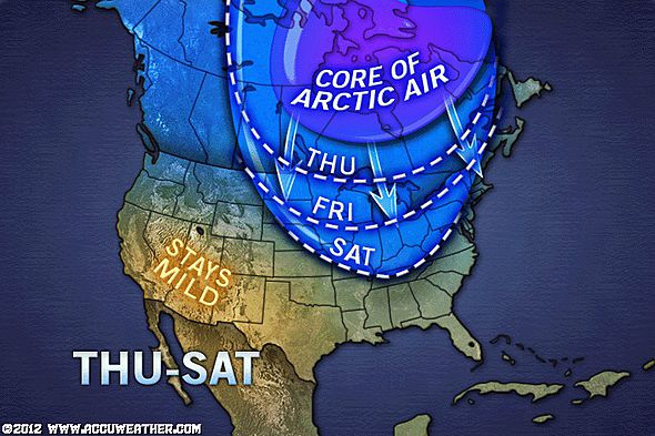
Potential Weekend Northeast Snowstorm To Be Followed By Arctic Blast

Models keep dissagreeing about the upcoming weekend where some show a snowstorm riding up the Eastern Seaboard, while others show barely anything. One thing is more certain though and that is it’s going to get cold from this weekend into early and perhaps mid next week.
How cold?
Saturday if not Sunday will see sub-freezing highs throughout the major I-95 cities and lows may dive to near 0 in Boston, 6 in NYC and Philly and 8 in DC.
VIDEO: Snow Hits Mid-Atlantic, Bitter Cold Weekend Ahead
ACCUWEATHER.COM
Little Snow, but Slippery Spots for the Mid-Atlantic
ACCUWEATHER.COM
A Cold Weekend Chicago to NYC
ACCUWEATHER.COM
Asia Latest
Western Japan sees heavy snows
THE WEATHER NETWORK
Powerful Cyclone Jasmine Rakes South Pacific Island
ACCUWEATHER.COM
Australia Latest
Strong To Severe Thunderstorms Impacting East Coast
THE EXTREMES OF THE DAY
TODAY’S US EXTREMES
COURTESY OF ACCUWEATHER
HIGH: 82° at Punta Gorda, FL
LOW: -23° at Clayton Lake, ME
TODAY’S UK EXTREMES
COURTESY OF THE MET OFFICE
HIGH: 47° (8.5°C) at Aultbea
LOW: 11° (-11.8°C) at Church Fenton
TODAY’S EXTREMES HERE AT MY HOUSE
HIGH: 38°
LOW: 25°
Thanks for reading.
-Mark


Recent Comments