>
Join The Conversation!
NEW LONG RANGE VIDEO NOW AVAILABLE, SCROLL DOWN!
Today’s Global Weather Headlines
Europe Latest
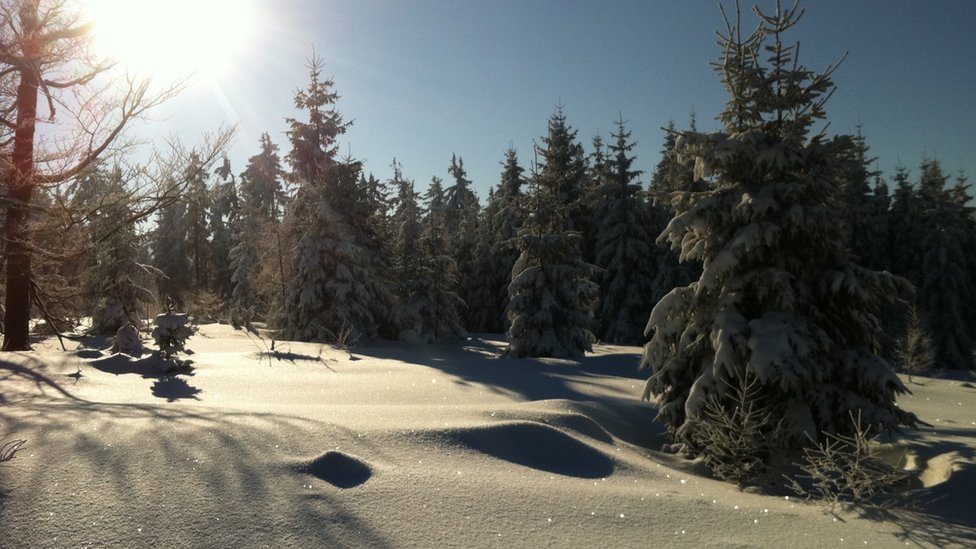
European Cold Wave Intensifying As Death Toll Rises To 80
People have been reportedly found frozen to death in their homes in Serbia while homeless across Ukraine are freezing to death on the streets. Temps continue falling and the reach is driving deep into Italy where forecasters expect the coldest weather in over 30 years
The Cold Hard Facts
– Schools have closures in northern Greece with temps of -16C (3F)
– Kneja, Bulgaria plummeted to a record -29C for 2nd straight day
– Eastern Bosnia reports temps down to -31C
– Schools and Colleges in Kiev, Ukraine were shut on Wednesday due to severe cold
– The Black Sea has frozen along the Romanian coast
Europe freeze: Heavy snow across continent
BBC
Europe’s cold snap claims more lives
BBC
UK’s weekend weather battleground
BBC
Deep snow brings Istanbul to halt
UPI
Cold Won’t Just Dissappear, It Will Take Time For Atlantic Air To Erode It, Snow Is Possible In Areas of UK
There is a lot of uncertainty over the upcoming weekend weather. The reason being is that while some models are showing a push of Atlantic air pushing into the UK which kicks out the cold back east, others show the cold lingering on into next week.
Models do have a tendency to remove cold too quick and often they not only kick out the cold, but they often don’t see just how cold that low level air is and where it’s positioned and this can be critical.
In my opinion, I think this weekend, at least Saturday anyway will be cold everywhere with highs only reaching 2 or 3C for many across Scotland and northern England, away from the immediate coast. The next 36 to 48 hours will bring more establishment of the cold with colder nighttime lows which mean during the day, the atmosphere will struggle to warm the air more so than in recent nights. This means the cold deepens of course. With cold air denser than warm, I suspect that as an Atlantic front approaches, this will force further sinking of the low level cold, explaining why it may still be very cool despite models showing warmth, the models may simply not see the cold air at the low levels remaining.
This persistency in the cold near the surface and warmer air perhaps riding up and over top of the cold may set the stage for allowing moisture and warmer air in, despite this cold and this would suggest that as rains fall into the cold lowest mile of the atmosphere, it would turn to snow. I believe that snow is of greater probability than rain at this time although rain is likely along western fringes and the isles where it is naturally warmer and where it’s breezier but once this air and moisture crosses into colder air, I believe snow will fall and not rain.
Next Couple of Nights Are Very Cold Even Near North Sea Coast of Low Countries
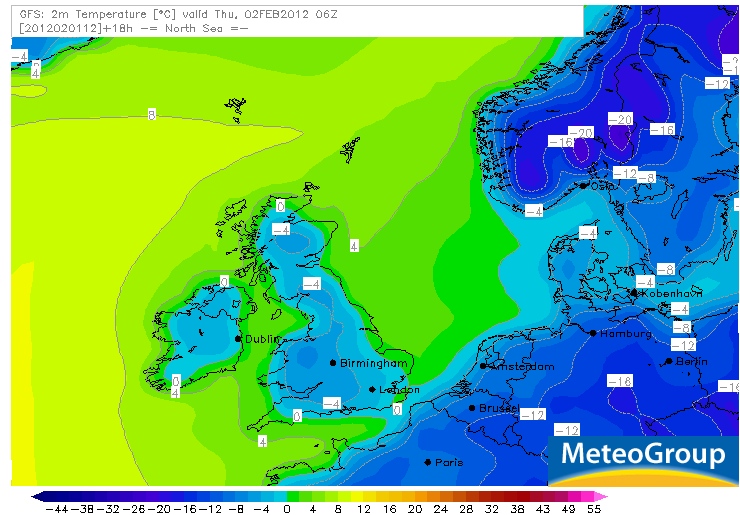
The intensity of the chill covering Europe is bringing some fairly low temps even to typically milder coastal areas of the Low Countries. Note the GFS 2 metre temp map showing the -8C line close to Amsterdam and the -12C line close to Brussels tonight, same will be for tomorrow night following another sub-freezing day.
This arctic chill is certainly grabbing headlines deeper into Europe but I think it’s important to notice the intensity of cold even over Belgium and the Netherlands where seaside towns may dip to -6C (20F) while just 5-10 miles inland, we could see -7 to -9C (19-16F) or colder. Amsterdam may get near to -9C by morning while I think Brussels may hit -11C. Given the absense of snow cover, that is impressive cold for cities this far west. Far eastern Belgium and Holland, some communities may approach -17 or -18C tonight and tomorrow night if conditions remain perfect.
Baltic Sea To See Extensive Icing Up As Core Of Cold Sweeps across Estonia, Lithuania, Latvia and Scandinavia Next Few Days
Baltic States To Suffer Coldest Air Yet With Tallinn, Riga and Minsk eyeing -30C in coming nights, bitter cold looks to ease over southeastern continent

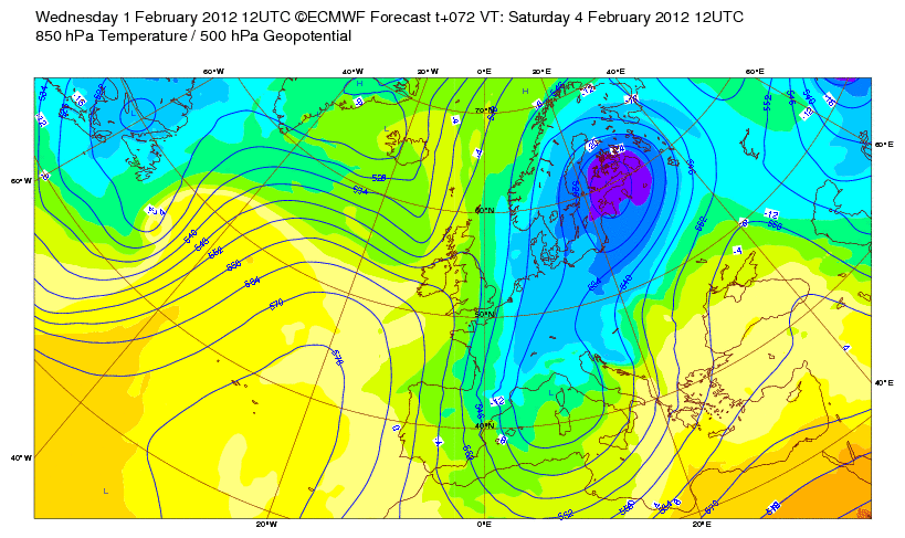
Mild of Next Week May Not Be So Mild If Latest Model Run Is Anything To Go By. More Substantial Winter Weather Looming For UK Next 7-10 Days
Models have been hinting at a warmer spell next week across the UK-Ireland and even Low countries but the latest run interestingly backs away from the warming slightly, especially over southeastern Britain and over mainland western and southwestern Europe, holding the chill deep into Spain, we’ll need to monitor this over the weekend and see with each new run whether this backward trend holds.
What I do feel more firm on is, I think we’re looking at a cold weekend rather than mild.
However, even if we do see a decent warmup from this week’s chill, the question is, how long will it last? If you notice the latest runs, the deep, severe cold appears to reload over eastern Europe and may bring a fresh surge of bitter cold back west across Europe like we’re currently seeing.
I am confident that if we do see warming, it will be short lived and what may follow could bring us worse than what we’re currently seeing. I believe a blocking pattern will setup in the next 10 days which could bring a very interesting mid to late February period for both Western Europe and the Eastern US.
The next surge of cold may well have greater snowfall chances and I hope to see some widespread snowcover followed by arctic high pressure which may bring us right back to December 2010. Who knows.. Only time will tell.
US Latest
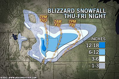
Blizzard To Follow Remarkable Warmth
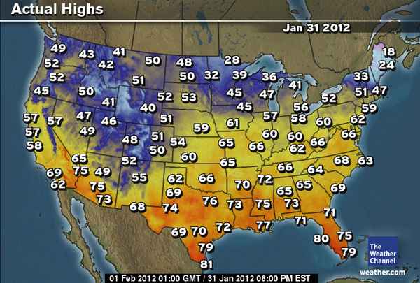
Yesterday saw an all-time record warm 69 degrees at Omaha, Nebraska for January, will be dramatically followed by heavy, windblown snow on Friday!
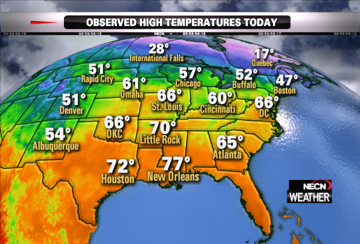
Some Eastern Records from Tuesday
Courtesy of Matt Noyes New England Weather Annalysis
In the Northeast, alone, records were set in a number of cities:
- Washington, DC – 66 degrees (old record 65, from 1993)
- Georgetown DE – 63 degrees (60, 1974)
- Islip, NY – 55 degrees (51, 1988)
- Bridgeport, CT – 54 degrees (53, 1974)
- Martha’s Vineyard, MA – 53 degrees (52, 1974)
- Ithaca, NY – 58 degrees (56, 1947)
- Roanoke, VA – 68 degrees (68, 1974)
- Lynchburg, VA – 68 degrees (68, 1916)
- Taunton, MA – 55 degrees (ties 55, 1974)
- Binghamton, NY – 54 degrees (ties 54, 1974)
- Atlantic City NJ 63 (ties 63, 1988)
Record warmth swarms the Eastern United States
MATT NOYES, NEW ENGLAND WEATHER ANNALYSIS
Blizzard Eyes Colorado, Nebraska, NW Kansas Thursday Into Friday
Blizzard to Target Colorado, Nebraska, Northwest Kansas
ACCUWEATHER.COM
Violent Storms to Threaten Texas, Oklahoma
ACCUWEATHER.COM

From Epic Cold to Blizzard Conditions in Alaska
ACCUWEATHER.COM
Alaskan volcano could erupt, disrupt international air travel
CNN
Canada Latest
Wild, Cold and Snowy Over Atlantic Canada!
Winter grips Atlantic Canada
THE WEATHER NETWORK

Let the melt in southern Ontario begin
THE WEATHER NETWORK
Australia Latest
THE EXTREMES OF THE DAY
TODAY’S US EXTREMES
COURTESY OF ACCUWEATHER
HIGH: 85° at Fort Myers, FL
LOW: -13° at Pinedale, WY
TODAY’S UK EXTREMES
COURTESY OF THE MET OFFICE
HIGH: 42° (5.6°C) at Lossiemouth (Moray)
LOW: 18° (-7.6°C) at Aviemore (Highland)
TODAY’S EXTREMES HERE AT MY HOUSE
HIGH: 37°
LOW: 29°
Thanks for reading.
-Mark


Recent Comments