>
Join The Conversation!
In Today’s Blog
Latest Long Range Discussion @ #LONG RANGE
Strat warming, trend towards -AO/-NAO supports latest European run showing arctic air pooling over Europe off Asia, reaching UK day-10
Today’s Weather Headlines
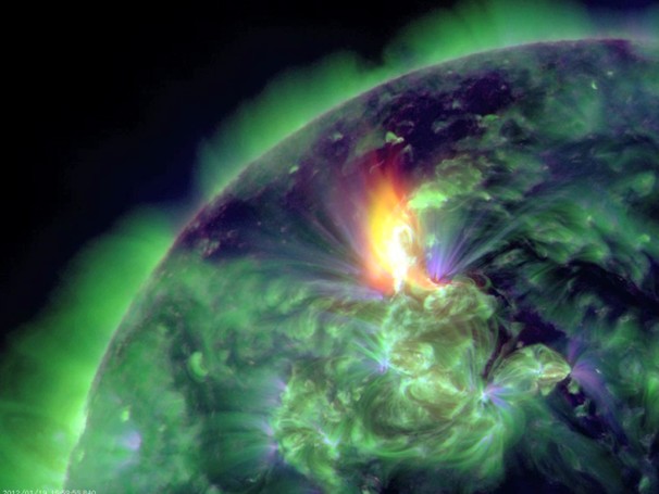
GLOBAL NEWS: Biggest solar storm since 2005 underway, will peak Tuesday
WASHINGTON POST
US Latest
Wild, Unusual January Tornado Outbreak Devastates South killing at least 2 people
BREAKING NEWS: IT’S CONFIRMED THAT ONE OF LAST NIGHT’S TORNADO WHICH STRUCK CLAY, ALABAMA WAS AN EF3 WITH WINDS ESTIMATED AT 150 MPH
LATEST NEWS
Survivors sought after deadly storms pound South
CBS NEWS
Severe weather rakes Southeast; 2 dead in Alabama
CNN
Latest Information on Monday’s Tornadoes
ACCUWEATHER.COM
OTHER NEWS FROM AROUND THE U.S
Northeast Icy and Foggy Start to the Week
ACCUWEATHER.COM
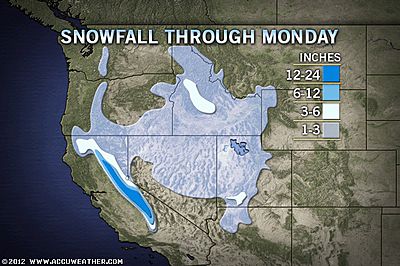
Rain, Snow Spin through California
ACCUWEATHER.COM
Late-Week Storm, then Colder in the Northeast
ACCUWEATHER.COM

Arctic blasts becoming more frequent for Lower 48 thanks to negative Arctic Oscillation

American Airlines Flight Turbulence Injures 6
ABC NEWS
Tornadoes, Taxes Coincide With Most Stressful Days of 2011
GALLUP WELLBEING
FOR FREQUENT WEATHER UPDATES, CHECK OUT THE FACEBOOK PAGE!
Canada Latest
Temps Moderate Across Canada
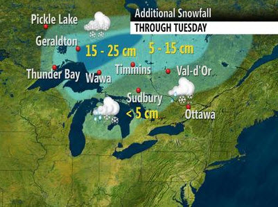
Parts of Ontario deal with wintery mix, temperatures on the rise
THE WEATHER NETWORK
Lack of winter in the Maritimes impacts ski season
THE WEATHER NETWORK
Powerful winds whip across BC
THE WEATHER NETWORK
Europe Latest
Colder night in store for UK with possible snow in places, Frigid air finally arrives in Scandinavia pushes southeastwards
DAYTIME HIGHS ACROSS PARTS OF SCANDINAVIA INTO RUSSIA AND AS FAR SOUTH AS UKRAINE WILL NOT REACH -10C (14F) ON TUESDAY, LOWS THIS WEEK WILL DIP TO BETWEEN -16 AND -25C (3 TO -13F) IN AREAS
UK-IRELAND OUTLOOK
After a generally bright, dry day throughout much of the UK with seasonal temps, this sets the scene for a mostly clear night ahead and with light winds and colder air aloft, frost will form quickly across many areas.
Expected lows tonight
Inverness -2C (28F)
Glasgow -1C (29F)
Carlisle -1C (29F)
Manchester -1C (29F)
Birmingham 1C (34F)
London 1C (34F)
Outlying areas may dip to between -2 to -4C, depending upon how long skies stay clear and winds light
POTENTIAL SNOW ARRIVES INTO EARLY HOURS OF TUESDAY MORNING
During the overnight, a band a rain will push into the western UK and as this bumps up against the cold air established during the early part of the night, this precipitation may turn to snow and even at lower levels anywhere from the Central Highlands into the Central Lowlands southwards through the North of England and even into the Midlands. However, as well as this being a hit and miss type of event, especially further south through Cumbria down into the Midlands, I am not expecting much in the way of accummulation with, at best, a coating in such areas as Glasgow, perhaps 1 to at the most 3 inches over the higher routes of the Highlands (watch out on the A9 and surrounding routes), the Southern Uplands (M74 between Blackwood & Beattock Summit) and the Trans-Pennine routes (watch out on A66 linking Cumbria with Yorkshire). As for the Midlands, I don’t see much more than some rain changing to a sleet mix . Anywhere which sees it snow will likely see it melt on impact with the ground. Only the odd lucky spot will see a covering I think.
During the day Tuesday, warmer maritime air will eventually raise temps following a changeover from snow to rain. Winds also increase out of the southwest and this will set the stage for a rather wet and windy Wednesday where gales may impact many areas of the UK-Ireland, especially across northern areas.
FRIGID AIR FILLS NORWAY, SWEDEN, FINLAND INTO RUSSIA SOUTHWARDS TO UKRAINE

With a persistent trough hanging over Scandinavia down into the southeast of Europe, it has been cold, been seasonal with highs generally in the -2 to -5C (28-22F) range for most.
However, a fresh push of truely arctic air is now covering Scandinavia, helped by the recent heavy and widespread snowfall which now covers all of Scandinavia and much of central and eastern Europe.
This fresh blanket of reflective white means arctic air can flow freely southwards without loosing much strength and finally, after a very mild start to winter, highs throughout Scandinavia into Russia south into the Ukraine will warm only to between -6 and -12C (21-10F) Tuesday through Thursday. Under clear skies at night, many towns and cities will cool towards -20C (-4F) with outlying, rural areas dipping into the -24 to -26C (-11 to -15F) range.
FOR FREQUENT WEATHER UPDATES, CHECK OUT THE FACEBOOK PAGE!
Australia Latest
Adelaide & Perth get extreme summer heat
Shade scramble for Australia Day scorcher
PERTH NOW
North-eastern suburbs swelter after loss of power
ADELAIDE NOW
THE EXTREMES OF THE DAY
TODAY’S US EXTREMES
COURTESY OF ACCUWEATHER
HIGH: 84° at Crystal River, FL
LOW: -8° at Westby, MT
TODAY’S UK EXTREMES
COURTESY OF THE MET OFFICE
HIGH: 53° (11.6°C) at Isles of Scilly
LOW: 31° (-0.8°C) at Leeming (N. Yorkshire)
TODAY’S EXTREMES HERE AT MY HOUSE
HIGH: 39°
LOW: 32°
Thanks for reading.
-Mark


Recent Comments