>
In Today’s Blog
Latest US Discussion @ #USA
Turning much colder across Northern Plains following record warm Thanksgiving. Snow expected across Minnesota
Latest UK-Europe Discussion @ #UK-EUROPE
Scandinavia to get slammed tonight by same low which brushed Scotland
Today’s Weather Headlines
Europe Latest
2nd storm in less than 24 hours is set to bring 70-80 mph winds across northern England, southern/central Scotland on Saturday
After weeks of nothing, Britain is expecting the arrival of yet another system which looks set to pack quite a punch with heavy rains and severe gales. Gusts topping 70-80 mph is expected from Cumbria up towards the Central Belt on Saturday

From Cumbria north through Dumfries and Galloway into the Lothians and Borders and across the Central Belt, we expect to see winds increase through Saturday morning thanks to another low immediately following the recent ‘weather bomb which saw a central pressure bottom out at an incredible 944mb (comparable to a STRONG Category 3 Hurricane) as it passed thankfully NORTHWEST of Scotland, this next system and it’s series of fronts will produce widespread gales with even severe gales expected across NE England and SE Scotland (Borders towards North Berwick). Heavy rain will also be an issue with localised flooding possible.
WIND AND RAIN WARNINGS HAVE BEEN ISSUED
As you can see from the latest weather warnings map provided by the Met Office, there are yellow high wind warnings issued from North Wales, the northern Midlands up through Cumbria, Northumberland, all of Southern Scotland and yellow warnings for heavy, possibly flooding rains have also been issued for Western Scotland from Argyll up through Lochaber.
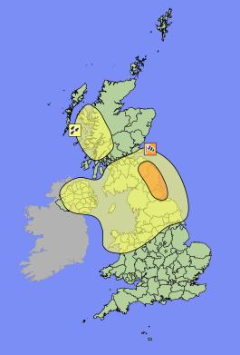
As for tomorrow’s weather, those winds may actually turn out stronger than those experienced from the first low as it’s centre will track somewhat closer to the UK and the strongest winds will impact a much more populated area.
Hurricane-force winds batter parts of Scotland
STV
Snow and large waves as winter storms continue
BBC
US Latest
Yet another storm rolls into Pacific Northwest, Strong, possibly damaging winds to whip Plains
East looking in good shape but once you reach the Plains on northwestward, the weather goes down hill!!
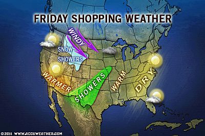
Thanksgiving Trip Home Trouble Spots
ACCUWEATHER.COM

Black Friday Snow, Wind, Cold Blasts Rockies, High Plains
ACCUWEATHER.COM
Post-Thanksgiving Snow Headed for Midwest, Central Canada
ACCUWEATHER.COM
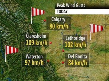
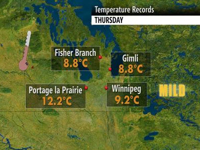
Canada Latest
Persistently stormy on British Columbia Coast, keeping it mild and windy across Alberta, Record warmth in Manitoba
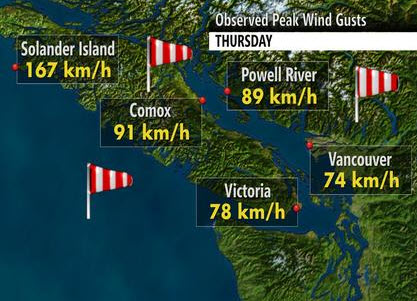
A parade of lows hammer BC
THE WEATHER NETWORK
Maritimers dig out from a wintery blast
THE WEATHER NETWORK
Record warmth rushes through Manitoba
THE WEATHER NETWORK
Asia Latest
Tropics Waking Up
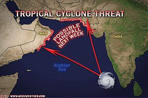
Tropics Coming Alive Once Again
ACCUWEATHER.COM
Deadly new, old floods wreak havoc in Thailand
CNN
THE EXTREMES OF THE DAY
TODAY’S US EXTREMES
COURTESY OF ACCUWEATHER
HIGH: 87° at Harlingen, TX
LOW: 11° at Big Piney, WY
TODAY’S UK EXTREMES
COURTESY OF THE MET OFFICE
HIGH: 56° (13.2°C) at Swanage (Dorset)
LOW: 33° (0.4°C) at Claunie Lodge (Aberdeenshire)
TODAY’S EXTREMES HERE AT MY HOUSE
HIGH: 50°
LOW: 37°
Thanks for reading.
-Mark


Recent Comments