>
In Today’s Blog
Latest UK-Europe Discussion @ #BRITISH ISLES-EUROPE
Warmth Builds through this weekend from Southern UK across the Continent
Latest US Discussion @ #UNITED STATES
A Nation of Contrast This Weekend!
Latest Seasonal Forecasts now available @ #LONG RANGE
Want to know what your winter has in store for you in 2011-12? See my Preliminary US & UK-Europe Winter Forecasts for my thoughts (Includes Video)
Today’s Weather Headlines
BREAKING: Huge Tumbling Satellite Could Fall to Earth Over US Tonight or Saturday, NASA Says FOX NEWS
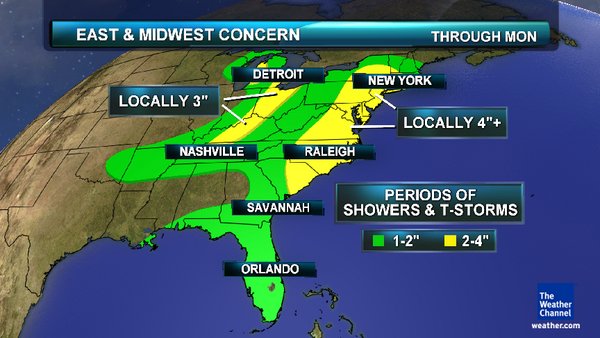
Heavy rains set to impact same areas hit hard by Irene and Lee from today through Monday, A widespread 2-4 inches of rain is expected with pockets of 6+ inches.
**Torrential rainfall and flash flooding has closed multiple roads in Frederick County, Md. at midday. Streams were out of their banks around Gettysburg, Pa. around lunchtime. Earlier in the day, the southern cities of Charlotte, N.C. and Columbia, S.C. were impacted by flash flooding. During the afternoon, Schuylkill County, Pa. was hit with torrential rain that closed and washed-out roadways.
Don’t drive through flooded roadways.
From AccuWeather.com
Weather Matrix, Jesse Ferrell of AccuWeather reported that 4.8 inches of rain has already fallen in south-central Virginia
Because the low is ‘cut off’, meaning detached from the great transporter of weather systems (the jet stream), and has halted in the worst possible place along with it’s front, rain will not only fall in the worst impacted areas from the recent flooding, but it may last days rather than hours, sound familiar?.
The front is situated to the west of the Eastern flood zone which got hammered by either Irene, Lee or both. This stalled low and front positioned where it is, means warm, moisture rich air flows up and across the flood zone in a ‘training’ fashion since there is little or no eastward progression of either the low nor the front and this means the moisture flow from both Gulf of Mexico and Atlantic continues to feed showers and thunderstorms up the East Coast throughout the weekend. The flooded areas from Virginia north through Delaware, Maryland, (including DC and Baltimore), New Jersey, Pennsylvania up through New England are all threatened by 3-6 inches of rain..
If there is one, the one silver lining in all this is the fact it’s a 3-6 inch rain event spread out over 2 to 3 days rather than 6 hours which would be far worse than what we saw with the tropical systems.
In the worst areas of flooding, only a mere 1-2 inches of rain is all that it will take for further flooding to occur. It’s most likely we will see more flooding but the question is how much, where and how bad.
-Mark Vogan
Related Stories
Big East Rain, Flooding Unfold Through Saturday
ACCUWEATHER.COM

Hilary Reaches Major Hurricane Strength Near Mexico
ACCUWEATHER.COM
Eastern Heavy Rain Threat
THE WEATHER CHANNEL
Hurricane Hilary in eastern Pacific and just off Mexican Riviera is tiny, but extremely powerful as a Category 4 storm.

Hilary Could Boomerang into Mexico, US
ACCUWEATHER.COM
Downburst winds from severe thunderstorm in Greece on Tuesday causes extensive damage!
Leftovers of Sonca & Roke to Slam West Coast of Canada, Washington Next Week
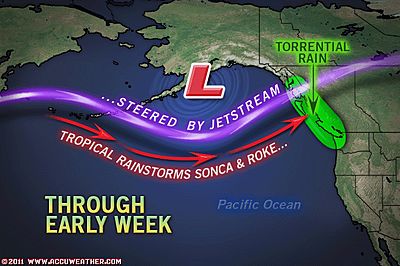
Typhoon Rain to Pelt Canadian West Coast
ACCUWEATHER.COM
110 MPH Winds, 40-Foot Waves for Alaska and B.C.
WEATHER MATRIX, ACCUWEATHER.COM
Huge Storm to Impact Gulf of Alaska to Western Canada
KEN CLARK’S BLOG, ACCUWEATHER.COM
Fall Starts Today – Winter is Coming
ACCUWEATHER.COM
THE EXTREMES OF THE DAY
TODAY’S US EXTREMES
COURTESY OF ACCUWEATHER
HIGH: 112° at Gild Bend, AZ
LOW: 22° at Medicine Bow, WY
TODAY’S UK EXTREMES
COURTESY OF THE MET OFFICE
HIGH: 68° (20.1°C) at Donna Nook (Lincolnshire)
LOW: 39° (4.1°C) Hurn (Dorset)
TODAY’S EXTREMES HERE AT MY HOUSE
HIGH: 60°
LOW: 49°
Thanks for reading.
-Mark


Recent Comments