>
 I DEDICATE THIS BLOG TO THOSE LOST AND FAMILIES LEFT BEHIND OF 9/11/2001
MY THOUGHTS AND PRAYERS ARE WITH YOU TODAY…..
Find this Blog On Facebook, Keep Updated Regularly.
In Today’s Blog
Tropical Latest @ #WEATHER TALK
Nate comes ashore near Veracruz, Mexico while Katia now off the tropical map, Maria and other waves no threat to land
Weather of 9/11/01
Ten Years Later: Weather for September 11 Memorials
ACCUWEATHER.COM

Scotland, N. Ire, Ireland and North of England to Endure Rough Monday night through Tuesday as Gusts to Hurricane-Force may be felt in the Glasgow to Edinburgh Corridor

IRELAND TO SEE FIRST IMPACTS FROM EX-KATIA, EXPOSED DONEGAL COAST COULD BE AMONST THE WORST HIT AREAS
IRELAND’S NORTHWEST CORNER WILL ENDURE THE FIRST OF EX-KATIA’S POWER WITH COASTAL GUSTS LIKELY TO CLOCK 80-90 MPH BETWEEN 10AM-5PM MONDAY WHILE THROUGHOUT THE NORTHERN HALF OF THE EMERALD ISLE GUSTS COULD REACH 65-85 MPH.
THE CORE OF STRONGEST WINDS ARE TO THE SOUTH OF THE LOW PRESSURE CENTRE AND THUS WAVE HEIGHTS ALONG THE DONEGAL COAST AND JUST OFFSHORE COULD REACH 35-55 FEET.
THE STORM’S WORST WEATHER WILL MAKE IT ACROSS THE ISLES OFF SCOTLAND BY 3PM ONWARDS, THE MAINLAND BY 5PM ONWARDS
AS MONDAY WEARS ON, THE CORE OF STRONGEST WINDS WILL BEGIN TO COME ASHORE ALONG THE WEST COAST OF THE UK MAINLAND AND THROUGHOUT LATE MONDAY INTO THE OVERNIGHT HOURS, THE STRONGEST WEST, SOUTHWEST WINDS WILL PROGRESS INLAND ACROSS SCOTLAND WITH SUSTAINED WINDS IN THE 35-45 MPH RANGE THROUGH THE CUT OF THE CENTRAL LOWLANDS BETWEEN THE HIGHLANDS TO THE NORTH AND SOUTHERN UPLANDS TO THE SOUTH, THIS GAP CAN HELP FUNNEL THOSE WINDS, MAKING THEM STRONGER, GUSTS COULD EASILY TOUCH THE DAMAGING RANGE OF 65-80 MPH EVEN IN GLASGOW AND EDINBURGH.
THE NORTH OF ENGLAND WILL ALSO SEE STRONG, POTENTIALLY DAMAGING GUSTS WITH THE HIGHER, MORE EXPOSED PENNINES LIKELY SEEING THE WORST OF THE CONDITIONS.
THE HIGHER GROUND OF THE NORTHWEST AND CETRAL HIGHLANDS WILL SEE THE WORST OF THE WINDS WITH SUSTAINED WINDS EXPECTED TO BE IN THE 65-75 MPH RANGE AND GUSTS COULD CLOCK 100-110 MPH. EVEN SOME COASTS AND THE EXPOSED WEST, SOUTHWEST SIDES OF THE ISLANDS COULD SEE 100 MPH GUSTS AND WAVES OF 20 TO 30 FEET CRASH ASHORE.
DAMAGE, POWER LOSS AND WIDESPREAD DISRUPTION TO THE TRANSPORT NETWORK IS EXPECTED…
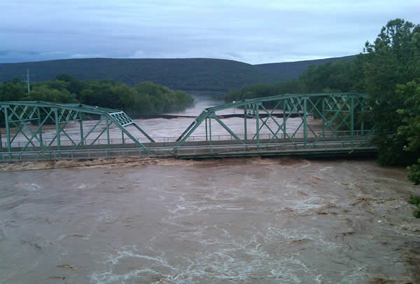
Susquehanna River has a History of Flooding
THE WEATHER CHANNEL

Southland thunderstorms drop hail and start fires
LA TIMES

Downpours Could Expand in the Southwest
ACCUWEATHER.COM
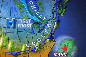
First Frost on the Way for Some Northern States
ACCUWEATHER.COM
THE EXTREMES OF THE DAY
TODAY’S US EXTREMES
COURTESY OF ACCUWEATHER
HIGH: 104° at Waco, TX
LOW: 30° at Leadville, CO
TODAY’S UK EXTREMES
COURTESY OF THE MET OFFICE
HIGH: 72° (22.1°C) at Gravesend (Kent)
LOW: 49° (9.4°C) at Drumadrochit (Loch Ness)
TODAY’S EXTREMES HERE AT MY HOUSE
HIGH: 57°
LOW: 49°
Thanks for reading.
-Mark


Recent Comments