>
BREAKING NEWS: Tropical Storm Nate has formed in southwest Gulf of Mexico as of 5am et.
Major Flooding Occured in the Baltimore-Washington Area this afternoon, Turnaround, Don’t Drown! (See below)

In Today’s Blog
Your Tropical Latest @ #WEATHER TALK
Mark’s Tropical Update: Looking at TS Maria, SW Gulf Disturbance and Katia’s impact to the US and even UK!
US Discussion @ #UNITED STATES
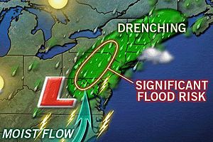
Narrow Channel of ‘Training’ Intense Flooding Rains from Richmond, Va to Harrisburg, Williamsport, Pa…. BUT WHY?
LIFE-THREATENING FLOOD RISK ENGULFS MID-ATLANTIC AND NORTHEAST AS REMAINS OF LEE BEAR DOWN
INTENSE, TRAINING RAIN BANDS NOW MOVING SOUTH TO NORTH OVER DC-BALTIMORE AND OTHER AREAS, A DANGEROUS SITUATION….

I shall try to get you some more information shortly @ #UNITED STATES on the current flash-flooding threat and what’s currently occuring around the Baltimore, Washington DC areas.. Stay Tuned.

Flash Flooding Strikes Areas of Washington, DC, Baltimore
THE WEATHER CHANNEL
Life-Threatening Flood Situation from Virginia to New York
ACCUWEATHER.COM
Tropical Moisture Still Fueling Mid-Atlantic Tornado Threat
ACCUWEATHER.COM
5″-6″ of rain coming; “Turn Around, Don’t Drown!”
MARYLAND WEATHER BLOG
Monster Wildfires Continue to Rage Out of Control Across Texas, 1,000 Homes Lost, Worst Year in State History for Fires
Wildfires in Texas Area 30 Percent Contained
FOX NEWS
Firefighters struggle to control Bastrop blaze
CBS NEWS
Crews Make Gains Against Raging Blaze Near Austin
ABC NEWS
With home now nothing but ashes, Texas family vows to rebuild
CNN
After Irene’s Remnants Slammed the UK with driving rains and tropical storm-force conditions, Is Katia Next for us?

We may see strong winds and driving rains return to the UK by late Sunday/Monday as Katia, currently a category 1 hurricane and to the east of the Lesser Antilles, she will continue moving WNW before taking a sharp loop around the western Atlantic, staying offshore of the Eastern US. As with Irene, she drove up the East Coast of the US and then made a northeast turn which quickly crossed the North Atlantic and brought wind and rain to us. It’s possible we see the same with Katia by late weekend and early next week so, prepare for strong winds and rain for potentially our second ex-hurricane landfall here in the UK in close to a week.
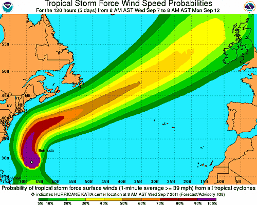
Remember, we are not waiting for a hurricane here, it’s not tropical in any way by the time it reaches us. If anything, it’s a slightly stronger, deeper area of low pressure we would typically see this time of year. The central pressure, if it holds, would be more on par with mid-winter depths and therefore we may see stronger winds, perhaps heavier rain bands but that’s about it. Once these systems are attached to the much more hostile upper level atmospheric environment of the westerlies which is thousands of miles from the UK and crosses over cold waters, it transitions into what is known as an extra-tropical storm, extra-tropical meaning it’s loosing tropical characteristics. While fully-tropical systems are what is known as ‘warm core’ systems and are driven by warm waters beneath, extra-tropical systems turn ‘cold core’ system, enteracting with the jet stream and from there they speed up forward motion dramatically, are fed by contrasting air masses and may move at 50 to 60 mph. That is why we may see a low that was once over eastern North America here in the UK in days a couple of days, whereas it may take triple the amount of time down in the lower latitudes where trade winds are majorly slower than that of the jet stream since the large-scale thermal environment in much more uniform than that of the latitudes nearer the pole..
Grab a coat! Storms batter Britain… and the bad weather’s here to stay for TWO WEEKS
DAILY MAIL
After last year’s snow chaos across Scotland, the transport department are getting plans in place
Scots emergency services already planning in bid to avoid repeat of snow chaos from last winter
DAILY RECORD
BE SURE TO CHECK BACK AS I SHALL HAVE CONTINUED COVERAGE OF THE MID-ATLANTIC, NORTHEAST FLOOD SITUATION IN THUIRSDAY EDITION OF THE BLOG, STAY TUNED!!
THE EXTREMES OF THE DAY
TODAY’S EXTREMES HERE AT MY HOUSE
HIGH: 60
LOW: 49
Thanks for reading.
-Mark


Recent Comments