>
SPECIAL COVERAGE OF HURRICANE IRENE 2011
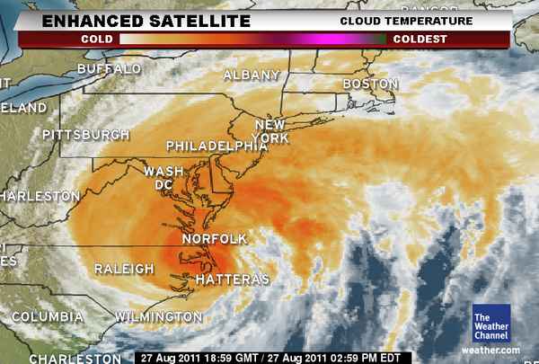
Hurricane Irene makes landfall at Cape Lookout, NC as a Category 1 storm, Cedar Island reports wind gust of 115 mph!
IMPORTANT INFORMATION: NYC: SUBWAY OFFICIALLY CLOSED
Latest Storm Information
Latest Stats on Irene
MAX SUSTAINED WINDS: 80 mph (Category 1)
WIND GUSTS: 105 mph
PRESSURE: 950 mb
DIRECTION: NNE at 15 mph
All Eyes Turning to The Major Cities Tonight into Tomorrow…
HURRICANE IRENE’S IMPACTS: THE FINER DETAILS

LIVE FEED:
– State of Emergency Declared in Philadelphia
– Tornado Warning for N. Sussex & S. Kent Counties in DE till 6.45pm
– 4 Deaths attributed to Irene in North Carolina
– Half Million without power in NC/VA
– New Bern, NC has seen 17 inches of rain!
– Tornado Warning In Effect Until 12.45pm ET for E. Sussex Co, DE
– Another person has died in NC while driving in Pitt Co. This is why folks driving around are risking their lives, literally!
– Buses & Trains Grinding to a halt across New Jersey
– 460,000 Without Power in North Carolina-Virginia
– Chesapeake Bay Bridge-Tunnel Closed
– President Obama Signs Emergency Declaration for State of Rhode Island
– 240,000 without power in North Carolina, 82,000 without in Virginia
– Cape Hattaras, NC reports gust to 87 mph
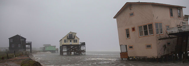
– Pier In Atlantic Beach, NC Collapses
– As Much As 9.25 Inches of Rain Has Fallen At Havelock, NC
Latest Information From the Big Cities
DC, Baltimore, Philadelphia, New York, Boston

New York Subways are shut down as Hurricane Irene Nears
NY TIMES
Many Rockaway Residents Ignore Warnings and Stay Put
NY TIMES
Transit Nightmare: Irene Snarls Transportation In Philadelphia And South Jersey
CBS PHILLY
MBTA Cancels All Services Sunday
CBS BOSTON
Mark’s Video Blogs
Viginia Beach, VA
**Tell me, why o why are those idiots out driving around in Virginia Beach, VA?
TWC’s Eric Fisher positioned at Virginia Beach, VA has been talking about how winds are much stronger and more destructive the closer he is to buildings where winds are whipping around the structures.
New York City
**I continue to be concerned about tall inner city buildings which may see 100+ mph winds which more than likely will punch out windows. With New York City likely to be closest to the eye of Irene, we may see 100-120 mph gusts at the top end of the Empire State Building and other tall, exposed skyscrapers. Pieces of glass and other objects may become airborne and fly through streets below.
Latest From the Networks
Irene slams into North Carolina coast slams into North Carolina coast
CNN
Hurricane Irene Hits North Carolina, Pier Collapses in Atlantic Beach
ABC NEWS
Hurricane Irene makes landfall in N.C
NBC NEWS

THE EXTREMES OF THE DAY
TODAY’S EXTREMES HERE AT MY HOUSE
HIGH: 63
LOW: 50
Thanks for reading.
-Mark


Recent Comments