>Visit my blog’s Facebook & Twitter pages and click ‘like’. There is regular updates and often when on-the-road…
TODAY’S TOP WEATHER STORIES
On Weather & Climate Through the Eyes of Mark Vogan
Fires burn across Texas with no end in sight
CNN
Hard-hit areas of South in ‘recovery mode’ after deadly tornadoes
CNN
At Least 44 Killed After Deadly Storms Ravage Southern U.S., North Carolina
FOX NEWS
Snow greets morning rush hour
WGN-TV CHICAGO
TODAY’S WEATHER ACROSS UK & EUROPE By Mark Vogan
Rest of the week to be bright, sunny and warm and getting even warmer by the weekend across Britain!
High Pressure that’s currently in contol is doing enough in bringing warm highs of up to 18 to 20C across areas of interior Scotland and England, however as this high builds over the next few days, we should see skies become sunnier, rather than mostly to partly cloudy and this intensification of the high will not only burn off and surpress cloud formation over most of the UK in the next few days but temperatures should warm for much of Scotland to 18C or warmer with a potential for 21, or 22C by Friday or Saturday. This would mark the warmest weather over central Scotland so far. As for England, well highs even tomorrow may reach the warmest levels of 2011 so far with a possible 24C or warmer in London. Could there be a 25C show up? Sure!


DRIER THAN NORMAL SOILS MAY BE AIDING IN THE STABLE, SETTLED PATTERN WE’RE SEEING
For this time of year, most of us living in this part of the world have seen pretty good, settled weather, it could be a lot worse. Heck, only last year at this time did we endure cold, even snowy weather. The chilly even lasted well into May last year. It couldn’t be more different this year as we’re struggling to see frosts by night and by day, well.. the shorts are getting worn despite the fact we’re not even into the later part of April yet. It’s been more like May while it was more like March or even February than April.
The overall fairly stable spring pattern we’re finding ourselves in may bode well further down the road as the persistence in the dry weather may continue drying out an already dry ground. That dry ground then feeds back to the atmosphere and can help intensify upper-level ridges aloft and thus provide persistent warmth and even much above normal temperatures.
964mb heights reach into northern England by Saturday!
THOSE DARK ORANGES ON THE EURO MODEL PROGRESS NORTH BY LATER THIS WEEK, PORTRAYING A VERY WARM LATER PART OF THIS WEEK


TODAY’S WEATHER ACROSS AMERICA By Mark Vogan
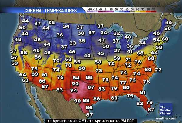
Large north-south temperature contrast today, Chicago saw snow this morning and still at 37 degrees while it’s 72 degrees in downstate Illinois
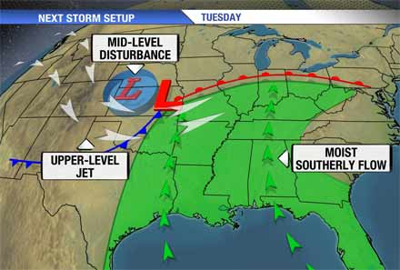
Tornadoes may return to the US weather map as early as tomorrow
As sickening as the title above may be, it’s reality in a season such as this one. The latest, in a long line of Pacific storms will enter the Plains tomorrow and like the last storm, a cold front will push out ahead of it, bringing the exact same potential across the same areas that endured the severe thudnerstorms and tornadoes in just the past few days.
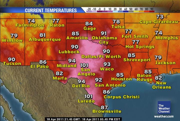
Dry continues feeding back on itself over Southern Plains
Unfortunately, in the New Mexico, Texas, Oklahoma region of the world and at this time of year, a dry late winter and spring can be a recipe for a long, hot and dry summer ahead. Once a dry and or wet pattern establishes itself over a given region and you tend to have a stable high pressure cell naturally over you anyway, this dry ground and high pressure feedback begins to intensify. Because this region lies beneath the sub-tropical high pressure belt and the soils are extremely dry, we may see much hotter than normal temperatures during at least the first half of the summer. The dry ground helps intensify the high aloft and thus hotter temperatures are produced. The hotter and dry the air beating down, the drier things will become.
Unfortunately, because of storm systems riding west to east across the central portion of the country, we’re seeing windy conditions persistent and this is helping fan those flames. The process just goes on and on unfortunately.
WEATHER TALK
By Mark Vogan
IT ISN’T TOO LATE JUST YET… IT SNOWED IN CHICAGO THIS MORNING!
You only have to look at what just occured from the Southern Plains to North Carolina and Virginia in the past 48 hours to see just how extreme the spring weather season is across the US. What’s futher added to it’s wild and fickle moods is the snow which fell and accummulated across the Chicagoland area this morning (Article). While today may struggle to see 40s and 50s across the north, 90s and even low 100s will roast Texas. The snow is a good reminder as to how much chill remains over the North, in fact you only need to glance at the current temperature chart across the lower 48 to see the very warm air to the south and very chilly air across the north. This is the major problem with all this very actice weather we’re seeing. Those large contrasting air masses is what is intenifying the Pacific jet and the storms in which ride along it.

WHAT’S REACHING TODAY’S BLOGS?

Tornado Fact Check from the North Carolina Outbreak
Jesse Ferrell, AccuWeather
Recapping Saturday’s Soaker
Philly Weather
Wild Severe Weather Outbreak Begs the Question of the Next Outbreak
Joe Lundburg, AccuWeather
WHAT’S ON TODAY’S WEATHERBELL BLOGS?
First Subtropical Cyclone of the Season Brewing?
Joe Bastardi’s Blog, WeatherBell.com
A study in contrast
Joe D’Aleo’s Blog, WeatherBell.com
THE EXTREMES OF THE DAY
TODAY’S US EXTREMES
COURTESY OF ACCUWEATHER
HIGH: 103 degrees at Laredo, TX
LOW: 10 degrees at Grand Marais, MN
TODAY’S EXTREMES HERE AT MY HOUSE
HIGH: 63 degrees
LOW: 37 degrees
Thanks for reading.
-Mark


Recent Comments