>Follow the Blog on Facebook & Twitter
TODAY’S TOP WEATHER STORIES
On Weather & Climate Through the Eyes of Mark Vogan
MAJOR SNOWSTORM TAKES AIM AT MIDWEST, THEN RETURN TO BITTER ARCTIC AIR!

Twin Cities Could See Up To 6 Inches Of Snow
WCCO MINNEAPOLIS
Blizzard Watch replaces Winter Storm Watch
WGN-TV CHICAGO
January’s recorded only 3 above-freezing days here; fewest in 34 years!
WGN-TV CHICAGO
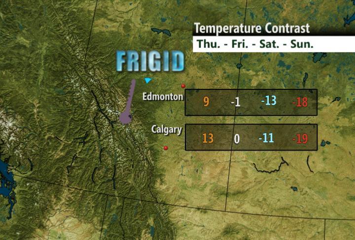
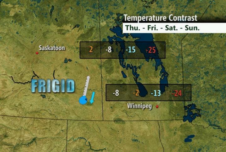
PRAIRIES WARMTH BECOMES RAPIDLY ERASED!
Cold Takes Bite Out of the Prairies
THE WEATHER NETWORK
TODAY’S WEATHER ACROSS EUROPE
TODAY’S WEATHER ACROSS AMERICA
From AccuWeather
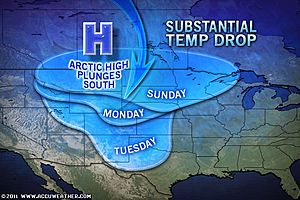
Super Bowl Cold To Shock Fan
AccuWeather
Southern Plains Cooldown Sunday, Worst Yet to Come
By Kristina Pydynowski, Senior Meteorologist
WEATHER TALK
By Mark Vogan
It’s Been A Tough Winter, Even for The Typically Frigid Midwest!
Here is a video from the Minneapolis Blizzard of December 2010
As for the Northern Plains and Midwest, this very air mass, also every winter, will be displaced south and down the continent, funnelled by the Rockies in the west and Appalachains in the east and with no large bodies of warm water to take the sting out of the super cold southbound air from northern Canada and Alaska, places such as North Dakota and Minnesota often endure the coldest weather in the lower 48 with multiple days remaining below zero, sometimes in the -10s and in extreme cases like seen in 2004, the -20s, yes for highs! Nighttime lows can dip below -40 and perhaps every 4 or 5 years, in a select few known Midwest cold spots, below -50 degrees.
The coldest night I’ve ever seen since closely following US weather was a reading of 54 degrees below zero in the tiny community in the Iron Range of NE Minnesota called Embarrass, southeast of International Falls
in January 2005. The first 50 below reading was in 2004 at Fosston, west-central Minnesota and the last sub 50 below reading was actually out East in far northern Maine in Big Black River, next to the New Brunswick, Canada border. The low hit 50 below zero and this actually broke Maine’s all-time cold record, the old record was -48 degrees.
WIND is the problem in the Midwest when Arctic high’s swing down from the north. Regularly in winter, like we’ve seen plenty of times this winter, with highs even in the relatively mild 15 to 20-degree range in a large urban area such as Minneapolis or Chicago, winds often blow out of the northwest at between 5 and 15mph, making it feel closer to zero. This winter has seen many daytime highs remain below 10 degrees and even a slight breeze makes the air feel more like 10 to 20 below zero. Even on the nights which dipped below zero, winds have been blowing. Anywhere from a slight breeze to a brisk 10 to 15mph wind creates windchills of 25 to 35 below zero (even in downtown Minneapolis or Chicago) and that feels worse than 35 below zero with no wind! The Midwest is often cold but made much worse because there is almost always a wind blowing and this means often, face coverage is needed and this makes for a long winter here. Across northern North Dakota and Minnesota where daytime highs and lows may be 10 to even 20 degrees colder than down in the southern half of Minnesota and within Minneapolis, wind chills often register 40 to 60 below zero during Arctic outbreaks and there has been no shortage of cold this winter. We just need to look at the amount of days in which days have remained below zero and nights under 20 or even 30 below zero. I would say, that International Falls, Duluth or Hayward, WI likely has a worse winter than perhaps Fairbanks, especially this year when Alaska hasn’t been too bad in terms of cold and the cold has been persistent over the Midwest. Also snowstorms will dump more snow than across more typically drier Alaska where moisture is more limited.
VAGARIES OF THE WEATHER
INDIA & SUB-CONTINENTAL WEATHER
BY RAJESH KAPADIA
W.D. passes away to the East (and weakens).
Sunday (30th. Jan) Precipitation details Gulmarg received 3″ of snowfall while Qazigund received 25 mms of snow. Pahalgam and Kokernag had mild snow flakes.
‘Due to fresh snowfall and slippery road conditions in Patnitop and Bannihal areas of the highway, the Srinagar-Jammu road has been closed this morning (Sunday),’
Srinagar recorded a low of 1.2c while Gulmarg was the coldest place in the Valley with mercury still settling at -6.3c.
Jammu city recieved 4 mms of rain
Meanwhile, Ladakh region also witnessed some respite from cold with Leh town recording -10c, and Kargil registering -8.8c.
In Delhi, people woke up to a chilly morning with drizzles but a bright sunshine followed in the afternoon.
However, the maximum was 22.4c, a notch below to yesterday”s reading.The city also received 0.5mm of rainfall.
Strong icy wind with sleet lashed higher reaches of H.P., with Kalpa receiving 10 cm of snow. Lahaul and Spiti headquarter Keylong was at -8.9c.
In neighbouring Uttarakhand, the weather was cloudy and cold wind brought down the temperatures. State capital Dehra Dun recorded a low of 7c.
In Pakistan, various parts of Balochistan and Karachi received rain between Friday and Saturday night.In Balochistan, it rained at Quetta, Mastung, Kalat, Khuzdar and other cities.
The rain caused extreme cold weather in some regions.
FOR THE VERY BEST INDIA, SUB-CONTINENT AND GLOBAL WEATHER, PLEASE CHECK OUT OUR PARTNER’S BLOG FOR THE VERY LATEST!
WHAT’S REACHING TODAY’S BLOGS?
First Look at the Groundhog Day Blizzard
Henry Margusity, AccuWeather
THE EXTREMES OF THE DAY
TODAY’S US EXTREMES
COURTESY OF ACCUWEATHER
HIGH: 89 degrees at Laredo, TX
LOW: -17 degrees at Cavalier, ND
TODAY’S UK EXTREMES
COURTESY OF THE MET OFFICE
HIGH: 47 degrees (8.6C) at South Uist (Outer Hebrides)
COLD HIGH: 31 degrees (-0.3C) at Spadeadam (Cumbria)
LOW: 16 degrees (-9C) at Pembrey Sands (Carmarthanshire)
TODAY’S EXTREMES HERE AT MY HOUSE
HIGH: 37 degrees
LOW: 33 degrees
Thanks for reading.
-Mark


Recent Comments