>Join me on Facebook and Twitter for the latest weather news and videos…
Today’s Top Weather Stories
On Weather & Climate Through the Eyes of Mark Vogan
BREAKING NEWS
Snow emergencies declared in both Minneapolis, St. Paul
Star Tribune
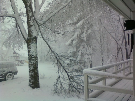
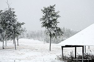
Snow Slowly Tapers (totals range from 6-12″)
Paul Douglas Weather Column, WeatherNation Founder and Meteorologist
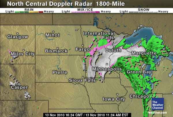
Upper Midwest Snowstorm Totals Piling Up
By Kristina Pydynowski, Senior Meteorologist
First major snowstorm arrives in Midwest on heels of near 70-degree heat and warm October!
By Mark Vogan
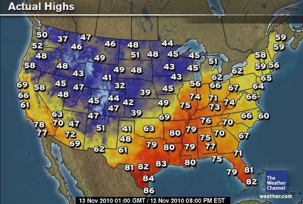
THE PARTY IS OVER! Folks across the Upper Midwest that have enjoyed an extended summer and temperatures even just 48 hours ago in the upper 60s and in some spots, low 70s, it’s cold and snow is accummulating!
Due to the slow eastward progression of the storm system that brought 6 to 20 inches of snow to Wyoming, Colorado and surrounding states and thus ahead of the front winds blowing out of the south ushered low to even mid-70-degree air all the way north of southern Minnesota, much of Illinois and other lower Midwest areas with St Louis warming into the upper 70s. Both Minneapolis and Chicago have enjoyed highs as warm as 68 degrees and about 4 days in the mid to upper 60s!. That very front that’s been trundling ever so slowly eastwards has now pulled the colder air east with it, erasing the warmth over the Upper Midwest and bringing the 40s that was over Minneapolis yesterday to Chicago. The 30s and snow that was over the Dakotas yesterday is now over Minneapolis today and may end up dumping upwards of 6 inches on the metro of Minneapolis. By tomorrow the 30s currently in Minneapolis will have progressed to Chicago with possibly snow falling, though this air will not be quite as cold further south and east, especially the nearer you are to Lake Michigan.

Today’s Weather across America
From AccuWeather
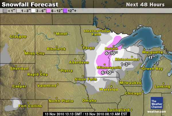
More Snow to Blanket Upper Midwest into Sunday
By Kristina Pydynowski, Senior Meteorologist
Substantial Rain Coming to Drought-Stricken South
By Kristina Pydynowski, Senior Meteorologist
Wind Pattern Promotes Marine Life in the San Francisco Bay
By Vickie Frantz, AccuWeather.com Staff Writer
Weather Talk
By Mark Vogan

NAO (North Atlantic Oscillation) is shifting negative, suggests colder times ahead for North America and Western Europe! Fits the forecast I have out!
If you live in eastern North America and Western Europe, including the British Isles and think it’s been mild, that appears likely to change as a warm pool is set to build over Greenland, thus sending lobes of Arctic cold southwards via troughs, one over a chunk of central and eastern
North America and the other down over the UK and western Europe.
Up until now, it’s been mild across the USA whilst chilly air has come and gone over the UK with a few sharp 24 to 48 hour cold spells but nothing sustained and nothing particularly below normal, afterall here, no day has been below 40 for the high and no day anywhere in the UK has seen below freezing highs.
The US is now seeing increasingly colder air filtering into mainly the West but after a very warm October and unseasonably mild start to November, it appears the NAO (North Atlantic Oscillation) is to turn negative after a rather neutral form over recent weeks. The neutral means little Arctic air can bleed southwards, especially when the AO (Arctic Oscillation) is also neutral as this holds the very cold air to the north and over the pole. This bottling up of Arctic air also means, it has a chance to build and grow stronger. When both NAO and AO is either neutral or positive it means low pressures dominate the US and Western Europe pattern, flooding both continents with mild maritime air. However the NAO and likely the AO will transition to negative and therefore the Arctic air will have a chance to drive southwards as high pressure builds up over Greenland over the next 2-week period. When this happens and warmer air aloft pushes northwards over Greenland, the cold, Arctic air will then drill south, either side of the ridge in the form of troughs (twin troughs) and this will likely kick off true winter for both North America and Western Europe.
I expect as of the 20th of November through the rest of the month, a colder pattern will evolve. This week, we should see colder nights than last where we saw a strong Atlantic driven pattern, same for the US with the strong Pacific pattern, though with a large western trough, we saw very warm conditions from the Plains to East Coast and colder inside the torugh out West which brought heavy snows to the mountains. The central and eastern warmth is being erased as very cold air starts to control the lower 48’s air space and I believe this will also be the case on this side of the Atlantic 10 to 20 days from now…

A December to remember is on the cards I believe. I shall be providing further details on this transitioning pattern in the coming days. Yes, we’ve seen a very wet pattern over the past month or so but remember, we saw a very wet, unsettled pattern last November, remember what followed in the week leading up to Christmas???
What’s Reaching Today’s Blogs?
50 Degrees of Diurnal Temperature Change
Jesse Ferrell, AccuWeather
Couple of Snow Events Coming into the East
Henry Margusity, AccuWeather
The Extremes of the Day
Today’s US Extremes
Courtesy of AccuWeather
High: 85 degrees at Camarillo, CA
Low: 1 degree at Alamosa, CO
Today’s UK Extremes
Courtesy of the Met Office
High: 56 degrees at Mumbles Head (Wales)
Cold High: 38 degrees at Tulloch Bridge (Highland)
Low: 30 degrees at Katesbridge (Co Down)
Today’s Extremes here at my house
High: 46 degrees
Low: 39 degrees
Thanks for reading.


>Took me time to read all the comments, but I really enjoyed the article.harry winston watches for sale