>
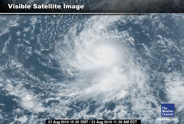
NEW: Note in the image above, this is the last section of the “loop” as you can see an eye forming!
Danielle now blowing sustained winds at 60mph and gusts beyond 70mph, this system appears to be reacting with a less sheared envirnoment and less dry air entrainment, meaning that it’s becoming stronger and should become a hurricane (winds over 75mph) perhaps within the next 12 hours.
Danielle looks much healthier, more concentric as cloudtops rise and cool. As this system ramps up, tightens it’s spin and grows more thunderstorms around it thanks to a drawing or pulling in of air at a faster rate from it’s surrounding environment, winds will increase and pressures drop off.
It’s over waters in the 80s and is tracking west, northwest. It is beginning to make me believe this system will remain a “fish storm” as it could well intensify quickly and if so, perhaps into a “major hurricane” in 48-hours, this will mean the storm grows much higher into the atmosphere, what’s that mean? It will connect with the upper-level flow and the weakness in the ridge that’s to the storm’s north, therefore finding a way out and to the north. Had this storm been weaker and ultimately less “tall” within the atmosphere, it would be been more likely to not catch the trough that’s pushing to the east away from North America and the Caribbean and therefore entered a much more dangerous and further west longitude that would have been more threatening to the US coastline.
Though it’s overall envirnoment is good and waters are plenty warm for intensification over the central Tropical Atlantic, Danielle will have limited fuel for intensification as only once over the west-central Atlantic do waters be warmer (2-6 degrees higher than the central Atlantic) as well as deeper, therefore I don’t see Danielle intensifying beyond a 120-mph cat 3 storm even if the shear drops off to near nothing around it. Had this storm been taking a course further west towards the Lesser Antilles, the Caribbean, Gulf and even off the US Eastern Seaboard would I be thinking tis storm could be aiming for cat 4 or even 5 strength, this is something to be considered for future storms that WILL not if form and get further west than what Danielle will. The US must be on guard as Danielle should be a wake-up call that this season has yet to begin proper.
As Joe Bastardi’s puts it, the sounds of the band is beginning, now we’re waiting for them to appear in full view.
LATEST FROM THE NATIONAL HURRICANE CENTER
Tropical Storm DANIELLE Forecast Discussion
LATEST FROM ACCUWEATHER
Tropical Storm Danielle Nearing Hurricane Strength…
Stay tuned for more regulat tropical updates as things become busier and more active across the Tropical Atlantic basin.
Thanks for reading.
-Mark


Recent Comments