>For the very latest and most up-to-date info, videos and more that you’ll not find here on the blog, check out the Facebook page and become a fan today! This blog is also on Twitter, become a follower during your visit today…
Today’s Top Weather Stories
On Weather & Climate Through the Eyes of Mark Vogan
BREAKING NEWS
Strong Line of Thunderstorms knocking on DC, Philadelphia and New York City’s door!!
LIVE FEED…
-4.45pm ET: Philadelphia, PA now dropped to an incredible 70 degrees with the storms… and a stunning drop to just 71 degrees at Baltimore, MD… Remember it was 99 degrees less than 2 hrs ago!
-3.45PM ET: Central Park, New York in past 15-20 minutes has dropped a further 9 degrees with a current reading now at 72 degrees, with heavy rains and locally strong winds effecting Manhattan.
ALERT: SEVERE THUNDERSTORMS NOW EFFECTING THE PHILADELPHIA AREA, STAY SAFE BY TAKING SHELTER!
TWC: Severe Thunderstorm Warning for Philadelphia County, PA
-3.25PM ET: Central Park, New York currently experiencing heavy rains and a temperature down to 81 degrees.
-3.25PM ET: In the past 30 mins, Baltimore, Maryland has dropped from 99 to 96 degrees as clouds signal the approach of the front and associated thunderstorms!
-3.00PM ET: Both Williamsburg and Franklin, Virginia are sizzling at 108 degrees.
-3.00PM ET: Farmville, Virginia is at 106 degrees and with a dew point of 73 degrees, it feels-like 118 degrees.
-3.05PM ET: Atlantic City, NJ at 95 degrees, feels like 101 degrees, The Airport, slightly inland is 98 degrees and feels like 104 degrees.
-3.05PM ET: Millville, New Jersey remains at 94 degrees with sunshine, HI of 102 degrees.
-2.45PM ET: Scranton, Pennsylvania currently at 68 degrees with light rain.
-2.45PM ET: Lancaster, Pennsylvania currently 73 degrees with Thunderstorms.
-2.45pm ET: Philadelphia, Pennsylvania currently 90 degrees with Thunderstorms.

A seperation of Extremes between Hemisphere’s
WHERE IT’S HOT, IT’S HISTORIC, WHERE IT’S COLD, IT’S HISTORIC
HISTORIC COLD SNAP FREEZES SOUTH AMERICA
Icecap.us
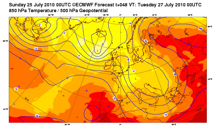
BRIEF RESPITE FROM EUROPE HEATWAVE
Refreshing Air from the North Atlantic and Northern UK reaches Germany but heat stands strong further east!
By Mark Vogan
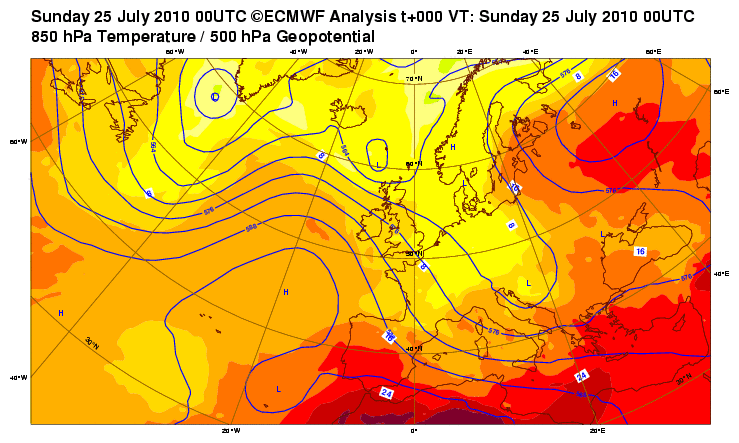
The period between 6-14, July saw the hottest period from Manchester, London across to Amsterdam, Rotterdam, Paris, Berlin all the way south to Madrid and across southern Europe as an extremely dry May and June with even the stage being set all the way back through last winter had harnessed the development of an abnormally strong upper-level ridge over Germany and this has extended as far east as European Russia and as far west as the southern United Kingdom. Between the huge, sprawlling high centered over Germany and a strong, deep trough with an axis lined up between Reykjavik and Glasgow and a core centered inbetween, thus pushing influence of the trough this helped transport superheated air off the western Sahara. Those winds flow out of the southwest and cross very little water due to it’s orientation, (across the far western Med Sea where waters are very warm and the narrow Gibraltar Strait which would have no cooling influence to the air mass. Coming from this direction, the Saharan air flowed across Spain, France, into Belgium the Netherlands, eastwards to Germany, helping increase, the already hot temps to between 95-105 degrees, The low countrues of Belgium, Holland and Denmark saw extreme heat as these winds crossed over 1,000 miles of already hot land (not water), allowing temperatures to climb into rare territory and within 5 to 6 degrees off the national heat record of 101 degrees. Gronigen in the north touched 94 degrees and Rotterdam in the south topped 95 degrees. It’s likely some spots recorded 96 or even 97 degrees.
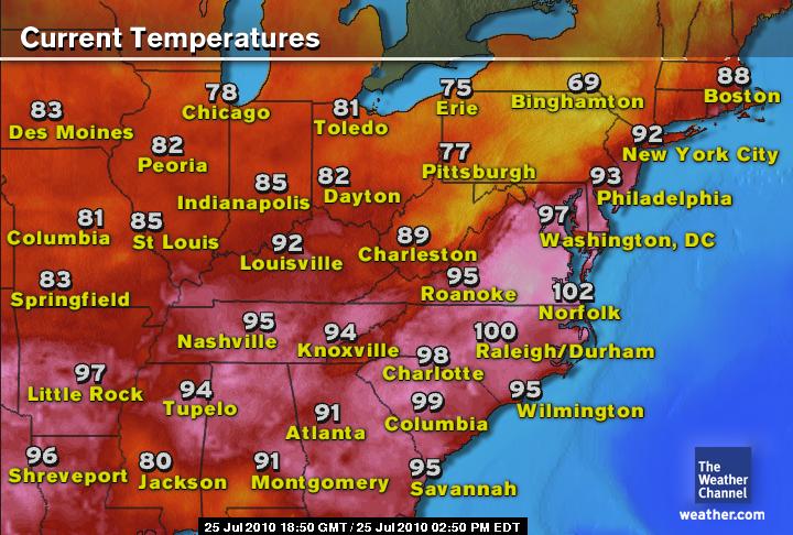
July 2010 Heatwave ‘Part Two’ for Eastern US makes History


32C line at 850mb level over Algeria & Morroco as well as Arabia, How hot does the surface get then?

Pressures have intensified over Algeria and Morrocco today as the 32 degree isotherm has showed it’s ugly head over Algeria and east Morrocco’s desert. What does that mean? Hotter surface readings as the desert land has literally no moisture to divert the sun’s attention to evaporation and not surface heating. On a typical July day the desert of interior Algeria, south of the Atlas mountains, temperatures usually climb to between 45-49C or 113-120 degrees. Today I wouldn’t be surprised if somewhere in Algeria touched 50C or 122 degrees, perhaps even 125 or 128 which would be 52 to 53C. As you can see the 32C temp at 850mb covers a large section of the Arabian penninsula and this is regular during mid-summer. The regular fight for hottest surface temperatures on earth runs between Death Valley, CA, Algeria, Saudi Arabia and Iraq as well as some surrounding hot countries of the middle east.
For the Arabian penninsula, the problem with the Gulf coast areas is, temperatures even at the shore of Qatar can rise to 122 degrees and humidity levels can be as high as 85-90 degrees due to waters being as warm as the low to even mid-90s!! A relatively narrow body of water surrounded by arid desert which heats intensely to 115 or higher tends to heat those waters to the highest levels anywhere on the planet… Of course those downright hot waters, will release likewise the highest dew point temperatures on the planet and yes, you’ve guessed it.. the highest heat index values on the planet. Often Heat indexes along the coast can climb to unearthly levels as high as 140-160 degrees….


Recent Comments