>Today’s Top Weather Stories
On Weather & Climate Through the Eyes of Mark Vogan
Today’s Feature Story
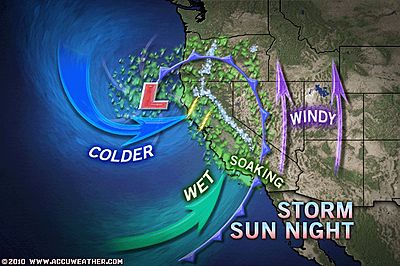
Rain, Snow, Wind & Hail Accompanying California Storm
From AccuWeather News
Soaking rain, burying mountain snow, hail and strong winds are accompanying a storm sweeping through California into Monday.
Rain moved onto the northern California coast earlier today, and will continue to spread over the rest of northern and central California through this afternoon. The rain will push southward to Los Angeles and San Diego tonight into Monday morning.

The rain will pour down heavily at times, leading to slow travel for motorists and possible flight delays.
Widespread flash flooding is not expected. Localized problems and mudslides could occur, especially in the burn areas of Southern California.
Following the band of steady rain, showers will keep California damp into Monday. Thunderstorms will also rumble over northern and central areas.
Some of the thunderstorms will drop small hail. A few funnel clouds could even be sighted. Be sure to seek shelter if you hear thunder, since you are then close enough to get struck by potentially deadly lightning.
Enough cold air will be in place for the storm to dump 1 to 2 feet of snow across the Sierra and the northern California mountains into Monday. The snow will be greatly welcome by skiers and operators of ski resorts, but will create nightmares for travelers.
Roads will rapidly turn treacherous as the snow comes down. This includes Interstate 80’s Donner Pass and the mountainous portions of Interstate 5 in northern California.
Later today into early tonight will prove to be the most dangerous time for motorists in the Sierra. Strong winds gusting between 50 and 70 mph will severely blow and drift the snow around, making travel virtually impossible.
Motorists should prepare for likely road closures. At the very least, officials may enforce travel restrictions.
Gusty winds will whip across other parts of California and the interior Southwest this afternoon into tonight. The winds will make driving difficult for semi-trucks and campers. The strongest winds could even overturn or steer these high-profile vehicles off roadways.
The strong winds will whip through the Grapevine section of Interstate 5, as well as U.S. Highway Routes 6 and 50 in Nevada. The winds threaten to kick up blowing dust in Nevada, creating dangerously low visibility.
This Story’s Source: Here
For more:
KCAL 9 Here
LA Times Here
Western Storm to Eventually Target Northern High Plains
From AccuWeather News
Here
Cool start in the Northern Rockies (esp W. Montana, Idaho) Mild in the East. Now it’s warming nicely from the Plains on eastward…
The Weather Channel MapsGraphics source: Here
Lack of Substantial Southern Rain This Week
From AccuWeather News
Strong Winds to Sweep Southwest on Monday
From AccuWeather News
caribbean
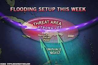
Haiti Now Faces Flooding Rain This Week
From AccuWeather News
Weather Talk
By Mark Vogan
Still No 100s just yet for USA
Despite a 98 degrees in Laredo, Tx & a 95 degrees reported at Louisa and Leesburg, Va from the recent heat wave which smashed over 1,000 heat records with some all-time April records fallen. We still haven’t seen the first 100-degree day in 2010. It appears the first 100 is beginning to run a little late as plenty of March’s have seen 100s, particularly over West Texas and the desert of southeast Calif.
Scotland enjoys Upper 60s and Abundant Sunshine, more cloudy and therefore cooler for England and Wales
After yet another 35-degree low and frost formation on cars and grassy surfaces this morning, we saw our second straight day of strong and abundant sunshine under a dominant high pressure cell covering UK airspace with more cloud than sun across many portions of England but clear skies and a strong sun ruled Scotland and Northern Ireland which allowed a rapid temperature rise after sunrise after this mornings cool start. Here at my house, we topped out at a pleasant 63 degrees by late afternoon (well into the 70s in direct sun) and we saw a national high top 68 degrees at Aviemore, which has seen the national high for the second straight day (yesterday 67)!.
Cooling Down as Clouds Increase by Tues-Wed
Tomorrow may equal or even beat todays 63 degrees here at my house, whilst we yet again could take a run at our first 70 of 2010, though clouds are filtering southward through the north of Scotland and we will likely see a drop of about 10-degrees in high temps for most places by Wednesday or Thursday, it should remain for the most part, dry, however!
Attention Californians, don’t put those rain coats away just yet!
As you can see from headlines, a new storm system is now barrelling south and east across the Golden State, bringing heavy, wind-driven rains to the low elevations including San Fran, LA, down to San Diego and snow to elevations above 5,000ft. Striong winds of up to 50-60 mph will also add to the spring misery after the tease of the 80s of late…. Spring rainstorms and moutain snowstorms are waning as we push into mid-April and those 80s will become the norm sooner rather than later… It’s only a matter of time now before we see the first 100s hit the Calif deserts!!
What’s Reaching Today’s Blogs?
Monsoon Watch – 1 & Extreme Heat!
From Vagaries of the Weather
Today’s Top Videos
California Storm Bringing Rain, Wind and Mountain Snow
From Ava Dinges, AccuWeather.com
Heat Wave Hits India
From Raychel Harvey Jones, AccuWeathercom
Todays US Extremes
Courtesy of AccuWeather.com
High 91 degrees at Goodyear, AZ
Low 6 degrees at Lakegeorge, MT
Today’s UK Extremes
Courtesy of the Met Office
Warmest High 69 degrees at Castlederg, Co Tyrone
Coolest High 47 degrees at Fair Isle (Orkney)
Coldest Low 27 degrees at Tyndrum, Perthshire
Today’s Extremes at my House
High 63 degrees
Low 35 degrees (frost)
Thanks for reading.
-Mark


Recent Comments