>HISTORY IS MADE IN THE BALTIMORE-WASHINGTON REGION WITH THREE MAJOR AIRPORTS NOW RECIEVING THEIR SNOWIEST SEASON ON RECORD! NOW PHILADELPHIA JOINS THE SNOWSHOW
CHECK THIS OUT
http://voices.washingtonpost.com/capitalweathergang/2010/02/winter_2009-2010_likely_snowie.html#more
Please scroll down for more info and graphics on this Historic Storm

ACCUWEATHER.COM FACEBOOK FAN UPLOADS THIS AMAZING PHOTO FROM THE STORM RAGING IN WESTERN BERKS CO, PA
http://www.facebook.com/photo.php?pid=139967&o=all&op=1&view=all&subj=71781612888&aid=-1&id=100000509746886
new information has been released on this post… new information will be updated throughout and a new post will go online for your photos which you can email to me directly at [email protected] any photos emailed will be credited!
 Baltimore (Image from Baltimore Sun)
BREAKING NEWS BOARD:
**NEW RECORDS SET **(Thanks to the Weather Channel)
Washington (Reagan): Current storm has dropped 9.8 inches of snow as of this afternoon. Seasonal total of 54.9 inches. (old record: 54.4″ set in winter of 1898-1899)Baltimore International Airport: 11.9 inches. Seasonal total of 72.3 inches. (old record: 62.5″ set in winter of 1995-1996)Washington (Dulles): 8.5 inches. Seasonal total of 72 inches. (old record: 61.9″ set in winter of 1995-1996)
**BALT-WASH NWS NOW EXPECTING 20 TO 30 INCHESOF SNOW AND NON-ESSENTIAL VEHICLES HAVE BEEN ORDERED OFF ROAD!
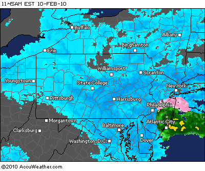 From AccuWeather.com
Snow totals from Jesse Ferrell’s blog
Davis, WV: 26.0″
Red House, MD: 22.0″
New Freedom, PA: 17.0″
Tabernacle, NJ: 7.5″
Wilmington Manor, DE: 7.0″
Whitacre, VA: 6.0″
Smithtown, NY: 5.9″
Washington, DC: 5.0″
STARK MESSEGE FROM THE BALTIMORE/WASHINGTON NATIONAL WEATHER SERVICE, linked from The Weather Channel
**Special Weather Statement for Southern Baltimore, MD**
Issued by The National Weather ServiceBaltimore/Washington, MD
11:33 am EST, Wed., Feb. 10, 2010
… EXTREMELY DANGEROUS WINTER WEATHER CONDITIONS CONTINUING THIS AFTERNOON FOR THE BALTIMORE-WASHINGTON REGION… CENTRAL AND WESTERN MARYLAND… SOUTHERN MARYLAND… AND THE EASTERN PANHANDLE OF WEST VIRGINIA…
DO NOT ATTEMPT TO DRIVE THIS AFTERNOON. LIFE THREATENING BLIZZARD CONDITIONS ARE OCCURRING ACROSS THE REGION AND WILL CONTINUE THROUGH EARLY EVENING. THE MARYLAND STATE HIGHWAY ADMINISTRATION IS URGING ALL MARYLAND DRIVERS TO STAY OFF THE ROADS DUE TO THE EXTREME WEATHER CONDITIONS. THE CITY OF BALTIMORE HAS IMPLEMENTED PHASE III OF THEIR SNOW PLAN… WHICH MEANS THAT ONLY EMERGENCY VEHICLES ARE ALLOWED ON THE ROAD.
WIND GUSTS OVER 40 MPH ARE OCCURRING THROUGHOUT THE AREA… COUPLED WITH FALLING HEAVY SNOW AND BLOWING SNOW… PRODUCING WHITE-OUT CONDITIONS ACROSS THE REGION WEST OF THE CHESAPEAKE BAY. THESE CONDITIONS WILL CONTINUE THROUGH EARLY THIS EVENING BEFORE GRADUALLY SUBSIDING AFTER 8:00 PM.
WHILE ALL REGIONS IN THE AREA ARE EXPERIENCING EXTREMELY DANGEROUS CONDITIONS… BALTIMORE COUNTY… THE CITY OF BALTIMORE… AND ANNE ARUNDEL AND HARFORD COUNTIES IN MARYLAND ARE EXPERIENCING PARTICULARLY PERILOUS WINTER WEATHER CONDITIONS THROUGH 3:00 PM.
PEOPLE ARE ENCOURAGED NOT TO PANIC… BUT TO SIMPLY STAY INSIDE… ENJOY YOUR FAVORITE INDOOR ACTIVITIES… AND RIDE THIS STORM OUT… THE HAZARDOUS CONDITIONS WILL BE IMPROVING LATER THIS EVENING.
IF YOU GET STRANDED IN YOUR VEHICLE… DO NOT LEAVE YOUR CAR TO TRY TO WALK FOR ASSISTANCE… YOU CAN QUICKLY BECOME DISORIENTED IN WIND DRIVEN SNOW AND COLD. THIS STORM WILL SUBSIDE EARLY THIS EVENING… SO WAIT IN YOUR CAR FOR EMERGENCY HELP TO ARRIVE. PERIODICALLY RUN YOUR ENGINE FOR ABOUT 10 MINUTES EACH HOUR FOR HEAT. ENSURE YOUR EXHAUST PIPE IS CLEARED OF SNOW AND ICE. CRACK YOUR WINDOWS TO AVOID CARBON MONOXIDE POISONING. TIE A COLORED CLOTH TO YOUR CARS ANTENNA OR WINDOW TO BE VISIBLE TO RESCUERS. FROM TIME-TO-TIME… MOVE YOUR ARMS… LEGS… FINGERS… AND TOES TO KEEP BLOOD CIRCULATING.
Very Latest information from TV and Newspapers across region
NWS: “Extremely dangerous winter weather”
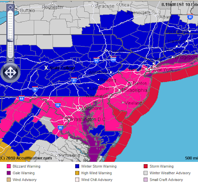
With Blizzard Warnings in effect until 7 p.m. Wednesday from the Virginia suburbs of Washington, through Baltimore to Philadelphia and New York City, the National Weather Service is warning that weather conditions have begun to deteriorate. With heavy snow and winds gusting as high as 60 mph, attempts to travel could become life-threatening.
Total snow accumulations still could reach 10 to 20 inches, with windblown drifts 2 to 4 feet deep.
Posted at 11:00 AM ET, 02/10/2010
Maryland Weather
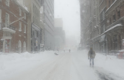
Blizzard continues: Snow piles up, winds rage
Snow decreasing southwest of Fairfax CountyWe are living through some of the most extreme winter weather we’ll ever experience in the metro region this morning. Heavy snow, winds exceeding 40 mph, and true whiteout conditions have paralyzed the entire region and steady snow will continue for a couple more hours or so (longer north and east of the District). Blizzard warnings span northern Virginia, the District and the entire state of Maryland. With the falling snow and wind, temperatures have plummeted into the low 20s with wind chills in the single digits.
Washington Post
Information below from yesterday
BLIZZARD NUMBER TWO OF FEBRUARY 2010
WARNING TO THOSE LIVING IN A CORRIDOR FROM MARYLAND TO MASSACHUSETTS.
BLIZZARD CONDITIONS TO DEVELOP AND WORSEN THROUGHOUT THE COURSE OF TONIGHT AND THROUGH THE OVERNIGHT HOURS. HEAVY BLINDING SNOW TO BE DRIVEN ABOARD FIERCE WINDS WHICH WILL CREATE MAJOR BLOWING AND DRIFTING REDUCING VISIBILITY TO ZERO… AN ADITIONAL 1-2 FEET OF SNOW ON TOP OF 1 TO 3 FEET ALREADY ON THE GROUND IS EXPECTED FROM THIS STORM FOR THE WORST HIT AREAS FROM THE LAST STORM INCLUDING WASHINGTON DC, BALTIMORE AND PHILADELPHIA.
SEASONAL SNOWFALL RECORDS MAY BE SMASHED BY THE TIME THIS STORM DEPEARTS OFF THE COAST LATE TOMORROW.
MORE INFORMATION TO FOLLOW: MARK VOGAN
If you have question comments or photos from your area of this storm, please email me AT [email protected] and I shall post them on the blog. Take care everyone.
Thanks for reading.

 Baltimore (Image from Baltimore Sun)


 From AccuWeather.com


>Can you please write a Winter Olympic Special? I love it when you relate these weather happenings to real life concerns of the Scottish people. All we care about at this time of year is curling and gold medals.
I think it's important that you, Mark Vogan, tell us what you would do to deal with the lack of snow and high temperatures.
Should they load all the curling stones, ski and snowboards into a van and head over to Tabernacle?
>As far as we're concerned, this bit of snowfall in America is nothing to be surprised about. It's a large mass of land in winter and hence cold. Chuck some moisture in, and you get snow. Big deal. It snows every year in USA and usually with copious amounts. I can't argue that accumulations vary from year to year in places, and that sometimes places get an accumulations greater than expected (95 % CI).
Regards
The Met Office team