
In this 2nd winter update, I wish to make this more thoughts based on what was discussed in the 1st update. Basing the latest drivers into potential outcomes.
DRIVERS: LA NINA / EASTERLY QBO / WARM OVER COLD NORTH PACIFIC & FADING -IOD

Some important considerations for Winter 25-26
We’re firmly in at least weak La Nina territory through the end of the year but this weakens or fades DURING winter…
There’s a LOT of focus through winter on the Arctic & North Atlantic Oscillations and to an extent rightly so but what DRIVES these positive, neutral and negative phases is what’s important.
Let’s start with LA NINA, it appears likely to peak between -1, perhaps -1.1C within Nino 3.4 sometime in December before weakening, perhaps returning to neutral in January or February onward as shown in the multi-model solution below.
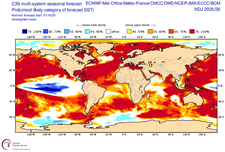

We still have a very warm North Pacific from Japan to Canada with cold La Nina signal beneath, this will play a key role in what goes on above.
Along with La Nina we have a pretty strong Easterly QBO. Easterly winds blowing within the stratosphere above the equator.

According to Richard Traut, the QBO is strongest since 2012 & 2014.

Recent strong EBO winters similar to current include 09-10 (highly blocky & frequently cold), 14-15 (cold USA but zonal and frequently stormy UK), 23-24 (stormy, mild with some cold spells).
Trio of La Nina, -IOD & EQBO supports a WEAKER polar vortex!

Within the stratosphere and only stratosphere, think of a belt or circulation of westerlies blowing over the pole (varying strength) then a belt of easterlies blowing over the equator. Those easterlies blowing against the westerlies can create friction and like a spinning top, nudge it, and a wobble can be created. This can (not always) weaken the polar vortex within the stratosphere and underneath within the troposphere. Opposite is true when westerlies blow over both equator and pole simultaneously.
Modelling sees a weaker mean zonal wind which determines strength of the vortex.
See charts…
Weaker PV’s & mean zonal winds can also lead to SSW’s, esp with Nina/-IOD/EQBO combos.

While a weaker polar vortex helps slow and wobble those westerlies over the pole, helping release polar air into the mid latitudes, WHERE that cold goes is an entirely different thing. That’s where ‘type of La Nina’ becomes important.
-AO But +NAO?
As previously mentioned, La Nina and EQBO’s tend to support a weaker polar vortex and it’s easy to then jump onto an increased chance for a -AO/NAO which would suggest cold North America, Europe and E Asia.
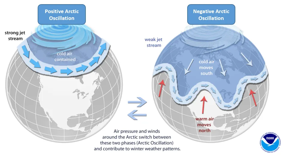
There’s also a strong relationship between AO and NAO but the two aren’t always in sync and a CP Nina/EQBO combo suggests this.
Weaker PV’s create a higher probability for higher pressure and warmer air to develop over the pole (-AO) which often results in the release of cold into the mid latitudes. However, POSITION of ridges and troughs is important and that’s where the NAO comes in.

You can get a -AO/NAO which brings cold to Europe and not N America and vice versa, however -NAO aren’t guaranteed with -AO’s and winters such as 2013-14 and 2022-23 are examples of -AO but +NAO.
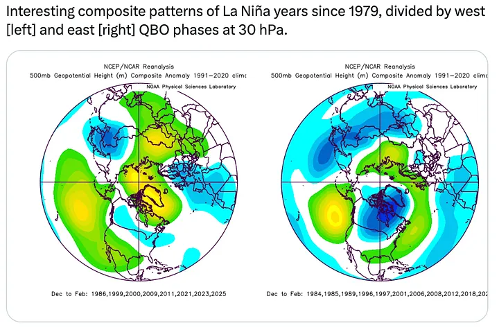
The below graphics show the importance of WHERE the core of cold sets up along the equatorial Pacific and whether it’s east or central. This can have huge influence on cold, mild or stormy in Europe.
Combo of warm Gulf of Alaska and CP Nina suggests a strong lean towards a +NAO, not good for shutting the door to the Atlantic.

I sort of struggle to pay much attention to analogues simply because global SST’s are considerably warmer in the past decade. This changes ocean-atmosphere feedback and so these traditional teleconnections are less effective compared to the colder past in my opinion.
This update has made me look more recent and there some decent similarities in terms of SST’s within Indian, Pacific and Atlantic, granted the QBO may not match up etc.
Below are the closest matches to the current SST state.
2025

2024

2022 (-IOD, stronger Nina but WQBO, nice similarity with warm N pacific/atlantic)

2020 (warm over cold pacific but neutral IOD, WQBO and cooler waters near UK)

Really beyond 2020, I think the differences become considerably greater.
What About The MJO?
That’s were position of warm and cold pools become important…


MJO phases & potential UK results: Phases 2-3 UNSETTLED/potential stormy, 4-5 mild, 6-7-8 increased blocking, colder potential…
SOLAR ACTIVITY… Richard Traut’s latest!


Earlier thinking…


Recent Comments