The coldest temperatures of the season have been felt by many in the Plains and Midwest this week.
Record warmth will return early next week for parts of the central and eastern U.S.
This is the time of year when large fluctuations in temperatures become common as the country transitions from summer to winter, and many locations in the eastern and central U.S. will experience large temperature changes heading into next week.
A shot of cold air infiltrated portions of the Plains and Midwest the past couple of days, and now it has pushed into parts of the East. This blast of chilly conditions will not last long as record warmth will return by early next week for areas east of the Rockies.
Warmer Temperatures Return
The good news for those that aren’t quite ready for this cold is that changes are beginning to develop this weekend. Above-average temperatures will return by early next week from the Plains into the Midwest, South and Northeast.
This change will be due to an area of high pressure in the East that’ll allow for a south to southwesterly flow to bring warmer temperatures to many of the areas that have experienced the chilly temperatures this past week.

Warmer Conditions Ahead
This weekend high temperatures will be 10 to 20 degrees, perhaps 25 degrees, above average from the Plains into the Midwest and much of the South. The warmer conditions will make it to the East Coast by Sunday or Monday.
Low temperatures will also warm considerably. Lows will range from 5 to 25 degrees warmer than average beginning this weekend in the Plains. The warmer mornings will then spread eastward early next week. In fact, lows by early next week will be warmer than high temperatures this week in some spots.
(FORECAST: Minneapolis | St. Louis | Dallas | Nashville)
Chicago is forecast to see lows in the mid-60s early next week, while the high this Thursday reached 57 degrees. Oklahoma City is expected to see lows around 70 degrees Sunday through Tuesday mornings, but on Thursday, temperatures held in the mid-50s.
Above-Average Temperature Forecast
Highs in the 70s and 80s will be common from the central and southern Plains into parts of the Midwest and South. Many 90-degree readings are expected in Texas. Highs in the 60s will likely reach the Canadian border, where highs in mid-October are typically in the 40s to around 50 degrees.
Some locations will see highs 20 to 25 degrees warmer than this week early next week. Kansas City, Missouri, for example, saw a high of 58 degrees Thursday, but temperatures will climb to into the mid-80s Sunday and Monday.

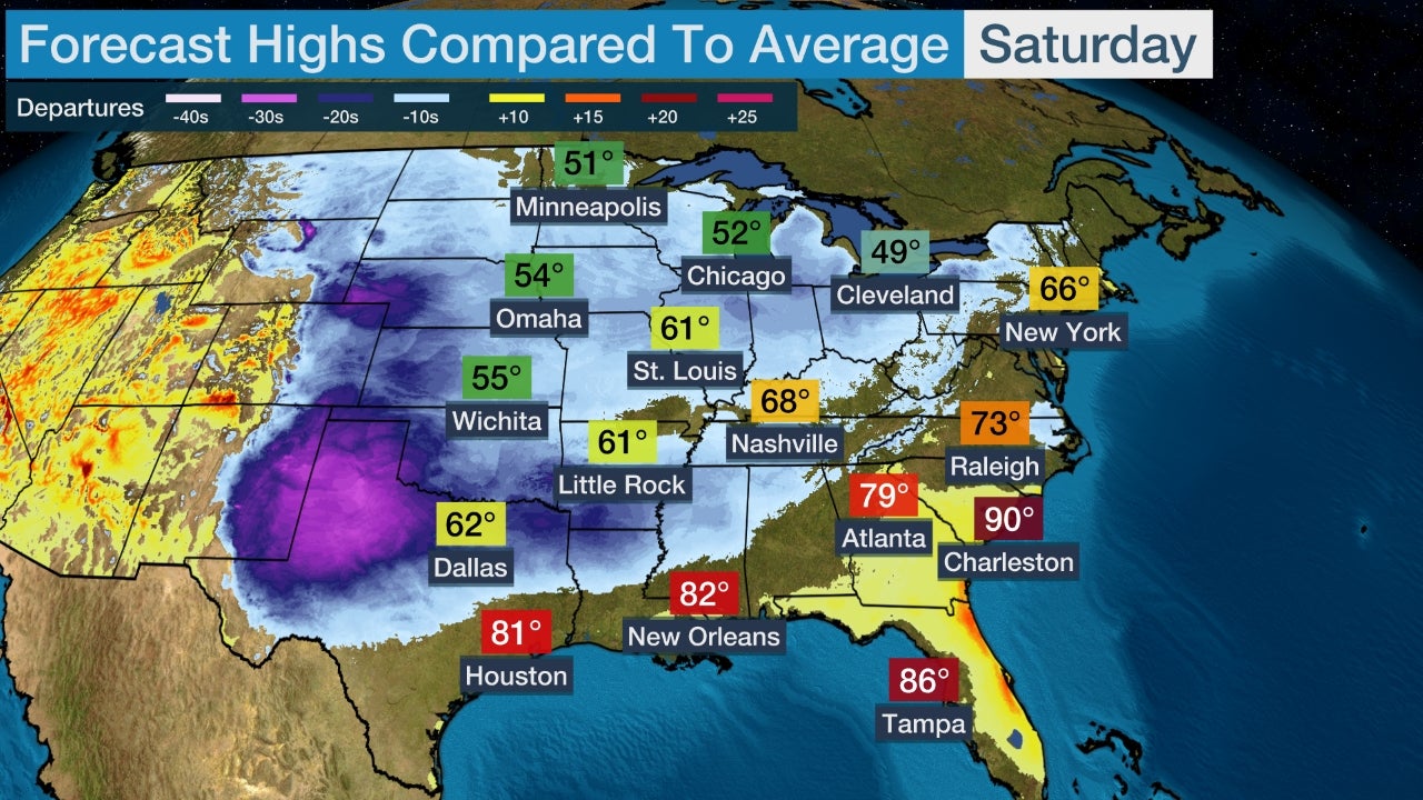
Forecast Highs Compared To Average
On Sunday and Monday, this warm-up will become more widespread. Highs will climb into the 70s as far north as New York City, with mid-80s returning to Atlanta. Low temperatures will be mild as well, with temperatures not dropping below 60 from the South into the mid-Atlantic and portions of the Northeast.
(MAPS: 10-Day Forecast)
Record high temperatures and even record warm low temperatures are also possible early next week.
On Sunday a few record high temperatures may be set in Texas, as well as western Kansas and eastern Colorado. This includes Austin, Texas and Dodge City, Kansas. Amarillo, Texas could even set a new record for hottest temperature so late in the season on Sunday, current record is 94 degrees on October 14, 1968.
Record highs are possible on Monday from Texas into Nebraksa and Illinois as well as eastward into Tennessee and Georgia. On Tuesday, numerous records are in jeopardy from Texas into the Northeast. Additional daily record highs may fall on Wednesday in the East, including New York City (current record is 83 degres) and Providence, Rhode Island (current record is 81 degrees).
Potential Record Highs
Low temperatures may also set records for being so warm. St. Louis is expected to see lows around 70 degrees Sunday through Tuesday mornings and current record warm temperature records are in the mid-to-upper 60s. Chicago may also set a record warm low on Monday (current record is 63 degrees) and Tuesday (current record is 65 degrees), as lows in the mid-to-upper 60s are expected.
By the end of the week, the record heat will just be a memory as a cold front will allow temperatures to return to closer to average for this time of year.
A Taste of Fall This Past Week
Cooler conditions have spread to the Northeast to start the weekend. Lows will be up to 15 degrees below average in the Northeast this weekend. High temperatures for the East, however, will only be slightly cooler, with highs near average.
(FORECAST: Pittsburgh | Raleigh | New York | Boston)
Some cities saw their coldest temperatures of the season so far on Thursday morning. This includes Omaha, Nebraska, and Des Moines, Iowa, which saw temperatures drop to right around freezing. The coldest reading so far this autumn had been 42 degrees in Kansas City, Missouri, but temperatures dipped into the mid-30s Thursday morning.
Widespread frost and some freezing temperatures occurred early Thursday. Lows plunged close to the freezing mark from the northern Plains southward into northern Kansas, northern Missouri, northwestern Illinois and portions of Wisconsin.
(MORE: When Does Your First Freeze Typically Arrive?)
High temperatures in the central and northern Plains, as well as for much of the Midwest, were quite chilly on Thursday. Highs topped out in the 50s as far south as Oklahoma.
[s2If current_user_can(access_s2member_level1)]
[/s2If][s2If current_user_cannot(access_s2member_level1)][magicactionbox id=”18716″][/s2If]


Recent Comments