
I would like to you wish all a Happy New Year and all the very best for 2016!
I woke this morning to our first dusting of snow.

Credit: Mark Vogan
Well it’s probably of no surprise but December 2015 is officially the warmest on record for the UK.

Credit: Met Office
The very wet weather in December also puts 2015 within the top 10 list of wettest years for UK and was wettest for Wales and Scotland. 176% of normal rain UK-wide.

Credit: Met Office
Warm and wet always makes for very cloudy days and it was a very dull month with just 67% of normal sunshine.

Credit: Met Office
More detail from the Met Office
31 December 2015 – Record breaking rainfall in December puts 2015 in the top ten wettest years on records going back to 1910
Latest early provisional statistics* from the Met Office confirm December has been record breaking both for its warmth and rainfall.
The UK mean temperature (1-29 December) is a record breaking 8.0 °C which is 4.1 °C above the long-term average. The previous record was 6.9 °C in 1934.
This anomaly of +4.1 above the long term average is the highest such anomaly for any calendar month since 1910 – beating the previous record which was +3.3 °C above average in April 2011. This means the temperatures this December 2015 were closer to those normally experienced during April or May.
Along with the remarkable warmth, and virtual complete lack of frost, there has been a marked contrast in rainfall across the UK.

It has been the wettest December on record for Scotland (333.1 mm), and for Wales (321 mm) and Northern Ireland is currently ranked 4th wettest with 208.1 mm. North west England has also seen record breaking rainfall, but central and southern England have been much closer to average. For the UK as a whole its currently the second wettest on record
For Scotland, this is already the wettest ever calendar month in our series since 1910, with 333 mm in the first 29 days easily beating the previous record of 301 mm which was set as recently as December 2013.
For Wales, only one calendar month (November 1929) has had more rain than December 2015, and if the last two days of this month brings more than 16 mm then this record will be broken.
| Provisional 1-29 December 2015 | Mean Temperature (°C) | Sunshine (hours) | Rainfall (mm) | |||
|---|---|---|---|---|---|---|
| Total | Diff from 81-10 avg | Total | % of 81-10 avg | Total | % of 81-10 avg | |
| UK | 8 | 4.1 | 27.4 | 67 | 211 | 176 |
| England | 9.4 | 5 | 31.8 | 67 | 120 | 138 |
| Wales | 9.2 | 4.7 | 25.5 | 61 | 321 | 194 |
| Scotland | 5.4 | 2.6 | 20.1 | 66 | 333 | 204 |
| N Ireland | 7 | 2.5 | 29.9 | 81 | 208 | 182 |
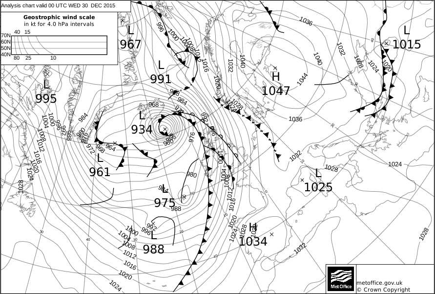
Storm Desmond played a significant part in making this a record breaking month, bringing record-breaking rainfall totals over the Lake District and a lot of rain over some other northern parts.
A humid south-westerly airflow continued the cloudy and overcast conditions seen in November, with little sunshine for most areas. This ensured several days of near-record-breaking (for the time of year) warmth, many individual stations having set new December temperature records.
The Christmas period was also unsettled, wet and mild. Storm Eva brought gales and heavy rain on Christmas Eve with a further Atlantic depression brought heavy rain and flooding to north-west England, north Wales and parts of Scotland through 25th to 27th. Storm Frank then dominated the headlines by 30th.
Looking at the year as a whole, until last week it seemed it would be unremarkable with a cool spring and cool, damp summer being offset by the mild end to the year.
However, the rainfall this week has changed all that and we have now had enough rainfall to propel the UK value in to the top 10 wettest years in our record since 1910. The wettest year is 2000 with 1337 mm and most of the other years in the top 10 have occurred since 1998.
This overall UK figure is influenced largely by the fact that Scotland and north west England have had an unusually wet year – 2015 is likely to end up being the second-wettest year since 1910 for Scotland, with only 2011 having been wetter.


| Provisional 1 Jan – 29 Dec 2015 | Mean Temperature (°C) | Sunshine (hours) | Rainfall (mm) | |||
|---|---|---|---|---|---|---|
| Total | Diff from 81-10 avg | Total | % of 81-10 avg | Total | % of 81-10 avg | |
| UK | 8.9 | 0.3 | 1477 | 108 | 1270 | 110 |
| England | 10.2 | 0.5 | 1607 | 108 | 866 | 101 |
| Wales | 9.5 | 0.3 | 1512 | 109 | 1589 | 109 |
| Scotland | 7.6 | 0.2 | 1274 | 107 | 1851 | 118 |
| N Ireland | 8.9 | -0.1 | 1334 | 106 | 1295 | 114 |
*Data from the Met Office’s UK digitised records dating back to 1910.
A full summary of December and the year will be available shortly on our climate pages.
Last updated: 31 December 2015
What’s been happening to our weather?
From Met Office
December 2015 will go down in meteorological history as one of the wettest – and warmest – on record. It will also be remembered for the devastating floods in Cumbria, Lancashire, Yorkshire and Scotland. The extensive flooding of homes and businesses, loss of electrical power, major damage to roads and bridges, and disruption to the rail network have caused great misery and incurred huge losses.
In this blog our Chief Scientist, Professor Dame Julia Slingo, discusses what factors may have influenced the record breaking weather we have seen in recent weeks.
As with all high-impact weather, the meteorological set-up was critical in defining the severity of these events. Throughout the month, the winds have come from the south or southwest, bringing both extreme warmth but also very high levels of moisture.
There has been a lot of debate whether this has been associated with El Nino – an intermittent warming of the equatorial Pacific Ocean which has been very strong this year – or whether this is a sign of a changing climate. The links to El Nino are certainly very clear in the set up of large waves (troughs and ridges) in the atmospheric circulation, which we expect to see in these events.

However, it does seem that this year the unusual warmth of the North East Pacific Ocean may have altered the position of these waves across North America and into the Atlantic sector, setting up the conditions for the devastating tornadoes in the US and for the southerly feed of moisture-laden air into the UK.

Storm Desmond in early December was associated with a strong west-south-westerly flow around the ridge over the eastern seaboard of the US, reaching far back across the Atlantic, as far as the Caribbean. With ocean temperatures well above normal in the southern part of the North Atlantic (see above) – possibly due to the much weaker than normal hurricane season this year associated with the current El Nino – the air was primed with more moisture than normal. This river of atmospheric moisture fed the storms that formed on a stronger than normal jet stream, and as the air impinged on the mountains of Cumbria, large quantities of rainfall were released.
Later in the month the southerly flow intensified, with a high pressure system to the east of the UK over continental Europe providing a block to the normal passage of the westerly jet. With colder than usual ocean temperatures over the northern part of the North Atlantic (see above), a strong temperature gradient formed which acted to strengthen the jet and set up the conditions for the formation of rapidly deepening cyclones, such as Storm Frank. These cyclones drew in warm, moist air from far south leading again to heavy rainfall and further flooding on already saturated ground. And the southerly winds on the eastern flank of Storm Frank, and strengthened by the high pressure to the east, enabled extremely warm air to penetrate, temporarily, the deep Arctic leading to very high temperatures.
The potential for December to be stormy and wet was picked up in the three-month outlook and is consistent with what we expect in early winter when there is a strong El Nino in place. However, early analysis suggests that the specific nature of this December’s extreme weather might be linked to the detailed structure of this El Nino, to the warmth of the north-east Pacific Ocean and to their combined effects on the atmospheric circulation.
As for whether climate change has played a role, we know that the overall warming of the oceans increases the moisture content of the atmosphere by around 6% for every 1°C warming. This extra moisture provides additional energy to the developing weather system, enabling even more moisture to be drawn in to the system, so that the overall enhancement of rainfall when the moisture-laden air impinges on the mountains of Wales, northern England and Scotland may be even more significant. So from basic physical understanding of weather systems it is entirely plausible that climate change has exacerbated what has been a period of very wet and stormy weather arising from natural variability.
More Typical Weather Opens New Year
After a record shattering warm and wet December, the first day of 2016 is actually much cooler than of late with temps in the Northern UK slightly below normal, about average across South.

Credit: Met Office

Credit: Met Office
As we go forward, our weather is becoming much more interesting following the injection of heat into the Arctic from Storm Frank.

Credit: NWS Twin Cities
As a result, large scale height rises are flipping the polar height field and in turn this will finally push arctic air out of the pole and into the mid-latitudes, something we’ve not seen yet.
Day 1-5

Credit: Tropical Tidbits
Day 6-10

Credit: Tropical Tidbits
Day 11-15

Credit: Tropical Tidbits
As stated in recent days, the building of high pressure over northern Europe means the first real blast of winter cold will spread westwards under the high but with a still ‘highly active’ Atlantic pattern, a fight is likely between Jan 4-10th which could result in the first significant UK snows of the season. See video for more.
GFS snow through the next 10 days.

Credit: Tropical Tidbits
See video for more.
[s2If current_user_can(access_s2member_level1)]
[/s2If][s2If current_user_cannot(access_s2member_level1)][magicactionbox id=”18716″][/s2If]


Recent Comments