
Published Nov 24 2016 06:50 PM EST
weather.com
Story Highlights
Otto made landfall Thursday afternoon in southern Nicaragua, and is now crossing into Costa Rica.
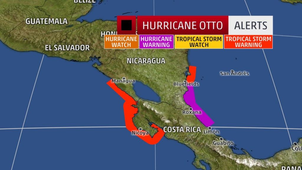
A hurricane warning is in effect along parts of the Central American coast.
Heavy rain, flooding and mudslides are the greatest concerns for Central America.
This is the latest-in-season hurricane landfall in Nicaragua.
Otto is the strongest Atlantic hurricane on record this late in the season.
Hurricane Otto is now crossing Central America near the border of Costa Rica and Nicaragua as a low-end Category 1. Otto will produce heavy rain that could cause life-threatening flooding and mudslides in parts of Central America as it grinds its way westward over land into early Friday.
Hurricane Otto made landfall near the town of San Juan de Nicaragua in southern Nicaragua just before 1 p.m. EST Thursday.
(LATEST NEWS: Otto Impacts Central America)
Maximum sustained winds were 110 mph at landfall, making Otto a Category 2 on the Saffir-Simpson Hurricane Wind Scale. Otto is the strongest Atlantic hurricane on record this late in the year, according to Eric Blake, a hurricane specialist with the National Hurricane Center.
A hurricane warning continues from Limon, Costa Rica, to Bluefields, Nicaragua. Hurricane condtions are likely along the Costa Rica/Nicaragua border through this evening.
A tropical storm warning remains in effect from north of Bluefields to Sandy Bay Sirpi, Nicaragua and from Puntarenas, Costa Rica to Puerto Sandino, Nicaragua.
(MORE: Hurricane Central)
Current Storm Status
The highest cloud tops, corresponding to the most vigorous convection, are shown in the brightest red colors. Clustering, deep convection around the center is a sign of a healthy tropical cyclone.

The clockwise wind flow around high pressure to Otto’s north is now steering the system westward after it was stalled for several days in the southwest Caribbean. This general westward movement will continue as Otto moves near the border between Nicaragua and Costa Rica, reaching the eastern Pacific Ocean by early Friday.

Projected Path
The red-shaded area denotes the potential path of the center of the tropical cyclone. Note that impacts (particularly heavy rain, high surf, coastal flooding) with any tropical cyclone may spread beyond its forecast path.
Tropical storm-force winds currently extend up to 70 miles from the center of circulation, making Otto a small hurricane. Hurricane-force winds extend to 15 miles from the center.
Heavy rain, flash flooding and mudslides are still the biggest concerns for Central America, particularly in Nicaragua and Costa Rica. Some locations may pick up 20 inches of rain from Otto.
In addition, areas of heavy rain well to the north and south of the circulation may trigger flooding in parts of Honduras and Panama.
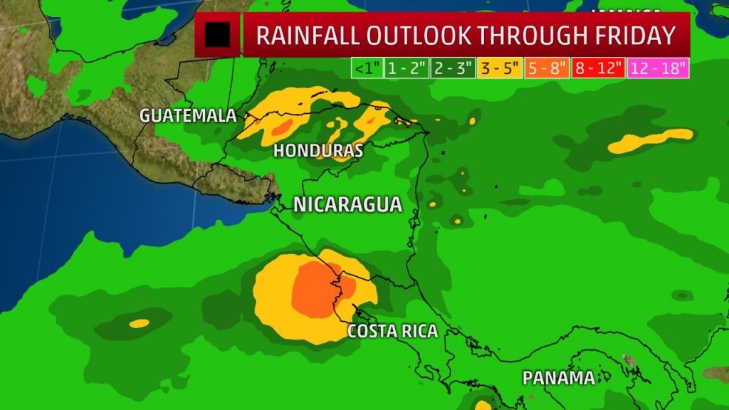
Forecast Rainfall
Locally heavier amounts in tropical cyclones may occur where bands of rain stall or repeatedly move over the same area, producing rainfall rates well over 1 inch per hour.
A storm surge from 3 to 5 feet above normal tide levels, with large, battering waves riding atop the surge, is expected in areas of the hurricane warning where winds will be blowing onshore in Nicaragua or northern Costa Rica. Life-threatening high surf and rip currents will occur through at least Thursday along the Panama, Costa Rica and Nicaragua.
Near the center of Otto’s track some structural damage to homes, downed trees and power outages are possible.
Otto will continue to weaken as it moves farther inland, with the circulation hampered by the higher terrain of Nicaragua and Costa Rica.
However, Otto is expected to be a tropical storm as it emerges into the eastern Pacific Ocean, but will then face increasing wind shear and dry air in the eastern Pacific into this weekend. When Otto re-emerges into the Pacific, it will retain the name Otto.
How Unusual is a Named Storm This Late in the Hurricane Season?
November Atlantic Basin tropical cyclones aren’t all that unusual.
In November, tropical cyclones typically form where the waters are warmest. Thus, one cluster of storms forming in November is in the western Caribbean Sea.
A second broad area of formation is in a broad swath of the western and central Atlantic Ocean, sometimes spinning off from an old frontal boundary, sometimes transitioning from a cold-core low to a subtropical or tropical cyclone.

Tropical cyclone origin points for November. (National Hurricane Center)
According to NOAA’s best track database, only 18 storms of at least tropical storm strength had formed on or after November 21 dating to 1950.
The last to do so was Tropical Storm Olga in December 2007. In fact, it’s now been over 10 months between the season’s first named storm, the aforementioned Alex, and Otto.
Tuesday (Nov. 24), Otto became the latest hurricane formation on record in the Caribbean Sea, surpassing Hurricane Martha in 1969, according to the National Hurricane Center (NHC).
Only nine tropical cyclones became hurricanes anywhere in the Atlantic Basin after November 21 from 1950 through 2015. The last to do so was Epsilon in December 2005.
Only one of those nine hurricanes occurred in the southwest Caribbean Sea, Hurricane Martha in 1969.
Furthermore, in NOAA’s entire best track database dating to 1842, there have been only three November or later Nicaragua hurricane landfalls, none of which were anywhere near as late as Otto.
Hurricane Ida: November 5, 2009
Unnamed Hurricane: November 1, 1890 (best track has 00 UTC landfall)
Unnamed Hurricane: November 4, 1887
More November Perspective
According to NOAA’s best track database, there have been 36 Atlantic tropical cyclones of at least tropical storm strength in November from 1950 through 2015. Twenty of those became hurricanes.
Just eight years ago, Hurricane Paloma reached Category-4 intensity, the second-strongest November hurricane of record, damaging or destroying nearly every building on Cayman Brac, according to the National Hurricane Center’s final report. “Paloma” was retired from the Atlantic hurricane name list following this event.
(MORE: Retired Atlantic Hurricane Names)
In the period of record from 1851 to 2014, no tropical storm or hurricane has impacted the western Gulf Coast from Texas to Mississippi.
Enlarge
November tropical storm and hurricane impacts in the United States
Systems that do develop across the Caribbean Sea can gain some organization, as the area has supported such late-season hurricanes as Kate in 1985 and Michelle in 2001. The former became the latest landfalling hurricane in Florida’s history on Nov. 21.
Since 1851, Florida has been impacted by eight tropical storms and hurricanes in November. The only other states with more than one November impact were also in the Southeast: Alabama, Georgia and North Carolina.
Typically, November tropical systems follow upper-level flow and cold fronts northeastward into the Atlantic Ocean.
In 2015, Hurricane Kate was an early-November oddity, forming from a tropical wave that first soaked the Lesser Antilles, then becoming the farthest north hurricane so late in the season on record north of Bermuda.
By the way, Atlantic Basin tropical storms even form in December, and January, on rare occasions.
Check back with us at weather.com for the latest on this tropical cyclone.


")


Recent Comments