The Atlantic Ocean goes through 20-30 year warm and cold cycles which have significant affect on the climate of Europe. Since 1996, the Atlantic has been it’s a warm mode and therefore summers steadily turned wetter in Western and Northern Europe. The spell from 2007 to 2012 was particularly dismal for Ireland, UK and Scandinavia, likely due to the turn to a cold Pacific in 2007. Remember the record wet summer of 2007? This was the year the Pacific turned cold and the Atlantic peaked in it’s warm mode, then came 2012, again the Atlantic re peaked in it’s warm phase but the Pacific flipped back warm, hence an even wetter and more record breaking wet summer for the UK, beating 2007.

The warm Atlantic is one thing but the reason for wetter UK summers goes further. The reason for increased rainfall throughout the summer months and increase in flash flood events is twofold, warm AMO and El Nino. This trend has been present since the turn from cold to warm Atlantic around 1996 but even this long term trend, there are exception years depending upon what state the ENSO is in. El Nino’s tend to lead to wetter but can also lead to warmer, i.e 2003, 2006, 2013 and La Nina’s tend to lead to drier.
Warm & Cold Blobs In Northern Oceans A Hint A Longer Term Change?
Between 2007 and 2012, we’ve had a warm Atlantic, cold Pacific and wetter than normal summers but in the last 3 years, there has been an anomalous warm and cold pools which have shown up and become multiyear events. The striking warm pool which showed up within the N Pacific south of Alaska may have been an initial indicator that the PDO was going back warm (likely peaked at the turn of 2016), and so is the flip from warm to cold pool within the North Atlantic a sign that the AMO is about to flip cold again? Possibly but what’s more important is how does this influence our upper air pattern and jet stream now?
This ‘cold blob’ may be helping led to bigger swings between warm, dry and cold, wet. 2013 was the warmest and probably driest summer in 7 years. Springs have been cooler and drier as waters start off spring cold around the UK but by the time we get to late spring, waters have dramatically warmed and once into the warm season, feedback kicks in, we reverse the height field from high to low pressure and hence why August’s have been wetter than June or July.

Cold Water Covering Most Of North Atlantic Earlky Spring 2015, Why The Cool, Wet Summer Forecast?
Although the El Nino is over and we’ve a La Nina forming, the cold water throughout this spring has led to higher than normal pressure which in turn has warmed the waters surrounding the UK.
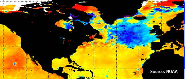
See the difference from below to above normal water temperatures between May 22

Credit: Tropical Tidbits
June 13

Credit: Tropical Tidbits
While warm water around the UK, cold south of Greenland during early summer supports high pressure south of Greenland and low pressure over UK, El Nino to La Nina transition summers don’t support warm and dry but quite the opposite.
Stuart Markham’s finding when compiling all El Nino to La Nina transition summers.
1900-1948

Credit: Stuart Markham
1950 onward

Credit: Stuart Markham
Article I wrote back in October 2012
This post is in response to a press release issued in recent days by Reading University which discusses the link between a warm North Atlantic and wetter UK summers.
If you’ve been following me back to when I first started blogging back in July 2009, you’ll be aware of my stance on why our summers here in the UK have been turning wetter and wetter. While I have always said that the warmer North Atlantic has been a large part of the reason for our increase in summer rainfall, however the Pacific plays an important role also. In fact, one could argue that it may play an even greater role when you think about it. The Pacific is where the El Nino and La Nina is and these play a GLOBAL role in distributing or redistributing ridge and trough positions and whether a region may see drier or wetter. It is the overall decadal warm/cold cycle within the Pacific which controls amount, intensity and length of time an El Nino/La Nina is alive for.
Right now the PDO is cold, so La Ninas are favoured. They last longer and their stronger. El Ninos which develop in between these longer, stronger La Ninas are more reactive to the colder signal. We saw this over the past two years with the dominance of the La Nina up until the warming and reintroduction to the El Nino took place but because the Pacific is rather cold, this Nino is weak just like it was back in 2009.
My theory is that since 2007, our summers have trended wetter. How do I come up with that year in particular? The reason, after several warm/dry summers here in the UK, we all of a sudden endured our second wettest summer on record. Remember the epic floods? The summer before was hot, dry and we recorded our warmest July day on record here in Britain.
Why the sudden flip between the warmth and dry weather of summer 2006 and the epic rains of 2007?
In 2007, the Pacific is said to have flipped into a cold phase, also, 2007 was a year where an El Nino was in control. The combination of a VERY warm North Atlantic, similar to this year in which back then, like this year, the arctic sea ice shrunk to it’s lowest levels ‘on record’.
So, el nino, cold PDO, very warm North Atlantic caused a very wet summer in 2007. Back then it was the 2nd wettest on record.
Take this year.. an even colder PDO than 2007, a slightly warmer North Atlantic (warmer because the sea ice shrinkage in the arctic surpassed that of 2007) AND… the El Nino, ALL these factors helped us beat 2007 in terms of summers rains. There is a clear link there and a fundamental point I am trying to get at and that is, yes the warm North Atlantic plays a vital role but so does the Pacific.
Afterall, is it a coincidence that the past 2 strong and back to back La Ninas which favour drier conditions here in the UK, did we see the driest two years on record. This is despite the warm AMO.
The Pacific has the power to override the trend of wetter.
Reading university claim this wet cycle may change in the next 2-3 years
According to the article, Reading university claim there could be clange in this cycle over the next 2-3 years. That I dissagree with. However, what appears likely is that we return to a La Nina next spring and so that could well lead to a drier summer in the UK, when going by recent years. However, the North Atlantic while could be peaking right now or over the next few years, should keep summers wetter given the Pacific should remain in a cold phase. If you continue to keep the Pacific cold and the Atlantic warm, our summers will remain wet. The slight alteration within this cycle will be the behavior of the ENSO and when in a cold mode (La Nina), it should be drier in the UK but when warm (El Nino), expect increased summer and autumn rains in the UK.
The rains are certainly down to a warm North Atlantic but the trigger to the major rains is most likely down to the warm mode of the ENSO index within a cold PDO.
The turnaround comes when the Atlantic cools and or the Pacific warms and that may be several years away yet.
Of course there is the link to winter and the increased blocking caused by the feedback of warm waters. That is another discussion for another time. If you want to read more on that however, have a read at my winter related posts which you can go directly to by clicking on the winter 2012-13 tab at the top of the homepage.
Is global warming the cause of our wetter summers?
If you look back at climate history, the answer is clearly no.
Yes, this is the wettest sustained period within summer months here in the UK basically in our lifetime, but the history of our planet, atmosphere and oceans go back LONG before we were around and so my point is simple. This has happened before and we have seen this between back between 1930-50 when summer rains were increased too due to a warm AMO. Of course what can often be ignored is that after these increased rains, we entered a cold period in which the Atlantic cooled and here in Britain, we saw multiple severe winters through the 60s and 70s.
Within that period, we saw several flood disasters.
According to the study and the book ‘Storm Force, August 1948 saw severe flooding which shutdown the main east coast line for 3 months. In August 1952 the Lynmouth flood disaster killed 34 people.
It happened before and it will happen again!
This year!
Why the increase in flash flooding during summer?
In account of this summers soaking, I have made reference to the role the warmth of the North Atlantic has on energizing low pressure systems crossing the Atlantic. The reason also for a more active storm track during summer when it should be much weaker is a lot due to an increase in a NEGATIVE summer NAO (North Atlantic Oscillation). Another important aspect which fuels bigger rains which result in flash flooding is the role in which warmer air and SST’s have down near the Azores. As low’s swing into the UK, trailing cold fronts drag all the way down to the Azores where it is naturally warmer and moister but with the warm AMO, this region tends to be warmer than normal and this energy does get transported north into circulations which cross the UK and so the rainfall rate and intensity is increased over the UK resulting in FLASH flooding as well as regard flooding.
To conclude
To round up, what won’t be highlighted in these publications, is the clear linkage between these increased summer rains and the colder UK winters. These are BOTH due to Warm North Atlantoc waters caused by the NATURAL warm cycle on the AMO.
See today’s video.
[s2If current_user_can(access_s2member_level1)]
[/s2If][s2If current_user_cannot(access_s2member_level1)][magicactionbox id=”18716″][/s2If]


")


Recent Comments