Only once every so many years do you get a monster storm system like the one we’re seeing now that’s still in the developing stages but has dumped close to a foot of snow in parts of North Carolina already.
A blizzard warning remains in effect from central Virginia up to southern New England including all big cities from DC to New York.

More than 7,000ft flights have been cancelled today.

Impacted airports include:
- Hartford, CT (BDL)
- New Haven, CT (HVN)
- Lexington, KY (LEX)
- Allentown, PA (ABE)
- Harrisburg, PA (MDT)
- Scranton / Wilkes-Barre, PA (AVP)
- State College University Park, PA (SCE)
- Philadelphia, PA (PHL)
- Pittsburgh, PA (PIT)
- Williamsport, PA (IPT)
- Baltimore, MD (BWI)
- Salisbury, MD (SBY)
- Boston, MA (BOS)
- Asheville / Hendersonville, NC (AVL)
- Greensboro / Highpoint, NC (GSO)
- Raleigh / Durham, NC (RDU)
- Albany, NY (ALB)
- Binghamton, NY (BGM)
- Elmira / Corning, NY (ELM)
- Islip / Long Island / Macarthur, NY (ISP)
- Ithaca, NY (ITH)
- New York LaGuardia (LGA)
- New York Kennedy (JFK)
- Newark, NJ (EWR)
- Stewart / Newburgh, NY (SWF)
- Westchester County / White Plains, NY (HPN)
- Providence, RI (PVD)
- Knoxville, TN (TYS)
- Tri-City, TN (TRI)
- Manchester, NH (MHT)
- Charlottesville, VA (CHO)
- Lynchburg, VA (LYH)
- Newport News, VA (PHF)
- Norfolk, VA (ORF)
- Richmond, VA (RIC)
- Roanoke, VA (ROA)
- Washington Dulles, VA (IAD)
- Washington Reagan National, DC (DCA)
- Charleston, WV (CRO)
- Huntington, WV (HTS)
With a strong high over Quebec, deepening trough over the Tennessee Valley that’s driving warm, moist Gulf air into the very cold, dry air being forced south out of Canada. This presents high potential for historic snow totals throughout the Mid-Atlantic and southern Northeast with tremendous pressure falls and upward motion.
Severe thunderstorms are lifting north, generating heavy rains, gusty wind and lots of lightning in the warm sector and heavy snow and thundersnow on the backside. All this is a good indicator of this highly energetic atmosphere.
Check out the below infrared satellite animation and see how the energy flows north and the curl becomes more impressive as the system comes together.

[s2If current_user_can(access_s2member_level1)]
Like we’ve seen is all the great storms, this is meteorological perfection!

Credit: Levi Cowan

Credit: CNN
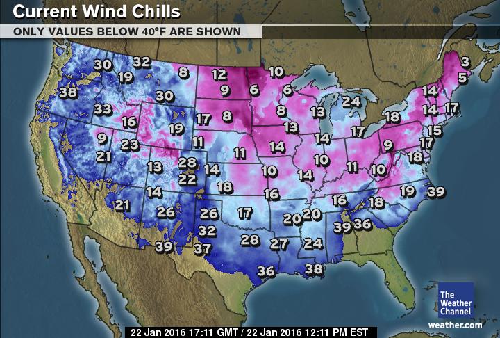
Current temps/wind chills

Credit: weather.com
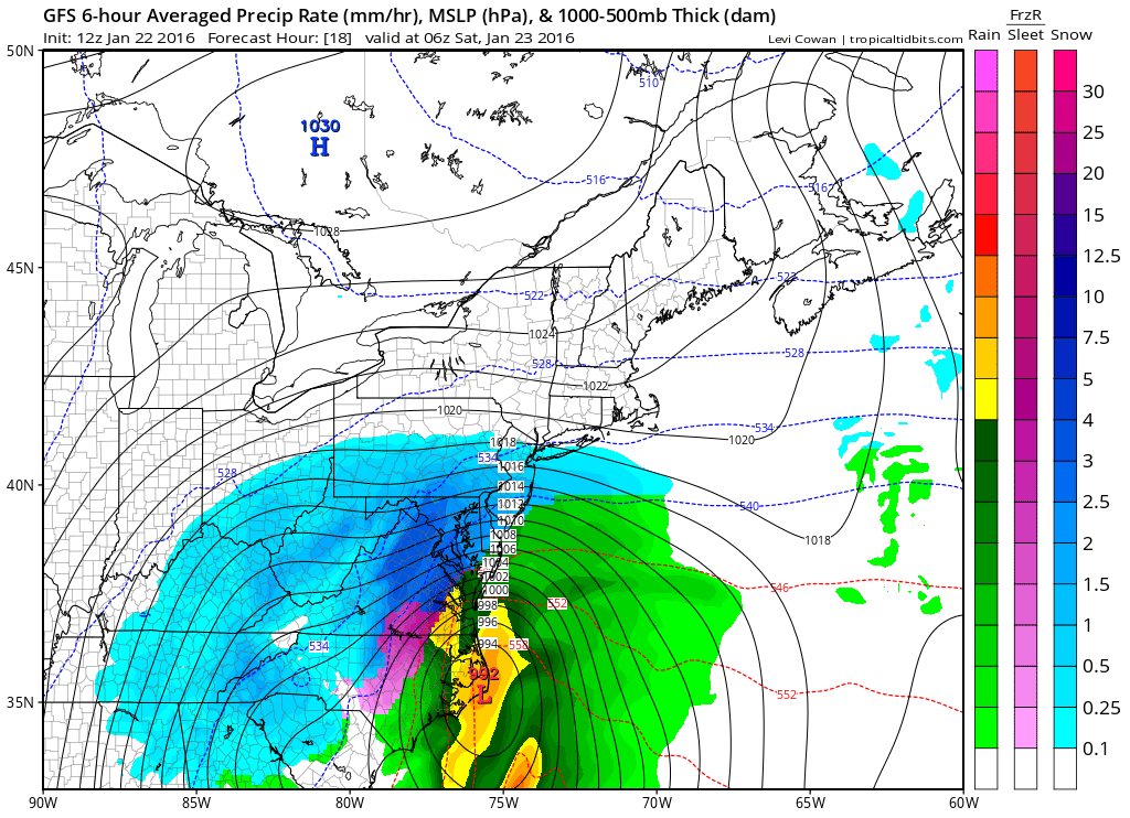
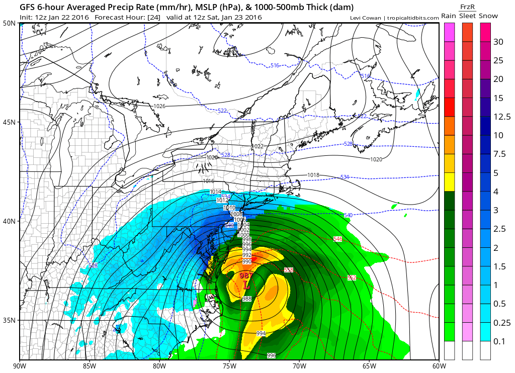
The real fun and games kick in when the coastal low develops and adds an injection of Atlantic moisture and heat into the system which will result in heavier, more concentrated snow bands and stronger winds blowing onshore.
Across the Southeast this thing is already producing severe weather, flooding rain and heavy rain as well as heavy snow.

Credit: Tropical Tidbits
Credit: Tropical Tidbits
Credit: Tropical Tidbits
This could easily drop 10-20 inches widely from central Virginia to Connecticut, locally 25-35 inches.

Credit: AccuWeather

Credit: AccuWeather
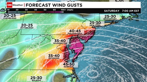
Credit: CNN

Credit: AccuWeather
BE SURE TO CHECK BACK LATER AS THIS WRITE-UP WILL BE ADDED TO.
See video for discussion.
[/s2If][s2If current_user_cannot(access_s2member_level1)][magicactionbox id=”18716″][/s2If]


")


The events described above took place on Friday, January 22, 2016 and the times are all for Central Standard Time (CST). The Nashville “Blizzard” was part of the so-called “wind-up” for the main event – the “monster” East Coast storm now hitting the coastal cities hard.
The Nashville “Blizzard”
We got caught up in a heavy snow band including our neighborhood in NorthWest Nashville at intersection of I40 &I440 freeways and extending out to the North and West over a fairly large area of NW Middle Tennessee & up into Kentucky. I happened to look out and was surprised to see heavy snow coming down at about 6 AM.
Went back to sleep as our forecast was for 5-8″ throughout the day and into this evening of predicted light and moderate snow so no big deal. Several hours later was woken by an end of the world type sound close by and called my husband working downstairs who announced we had had just had a huge “thunder snow” event. He said lightening lit up the sky outside our Eastern windows like nothing he’d ever seen. At that time there was continuing heavy snow at a rate of about 2″ an hour with wind gusts creating a blizzard effect.
Although the snow lightened up around Noon for about a half hour it returned to heavy mode and stayed that way. By then we had lost two big trees and several huge branches in the back yard and our flat roof modern style house had begun to look like an igloo. It’s about 10:30 PM CST now and it’s still coming down. We have at least a foot of good accumulation everywhere and it’s not likely to melt soon with the current temp at 23F and falling and the high for tomorrow at 30F, low at 12F.
There are several predictions as to when this storm will move off to the East. The NWS has us under a Winter Storm Warning until Noon tomorrow. Local forecasters have this storm leaving the area by 11 PM CST tonight. Well bless my soul! Just looked out the windows and checked the radar to verify – our little blizzard is just now finally moving out.
Local forecasters had a long winded explanation for all this but I’ll leave that to the imagination of anyone who happens to read this.