
Despite a still ATLANTIC pattern and firmly positive NAO, winter has definitely made it’s presence felt across a large swathe of Ireland, UK and parts of the near continent. The northwest flow has become more pronounced following the big low of a few days ago. Snowfall has become pretty substantial above 2-300m with ice and dusting to lower levels. A mean ridge positioned in just the right place has allowed winter and below normal temps to impact still and on the backside of two lows, ARCTIC air is punching southward today making for the coldest day yet.
This morning, folks in Ireland, Northern Ireland, Scotland and England are waking to snow, what a difference a year makes and that’s with a +NAO. Who would’ve thought?
Many parts of the snow covered north will fail to even reach freezing today with further heavy snowfall expected within the showers.
[s2If current_user_can(access_s2member_level1)]
Tonight will be the coldest night yet with a widespread hard frost expected. Lows widely -2 to -4 but where snow lies, we may see the first -10C by dawn tomorrow either over northern England or Scotland.
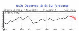
MILDER air comes in Sunday with the next Atlantic depression and by later next week, we may be contending with a repeat of this week with a deep low near Iceland bringing initial mild air along with heavy rain followed by a temperature crash and rain quickly changing over to snow. The bumpy up and down pattern shall remain through probably the next 2 weeks given the NAO looks to remain positive.
See video for thoughts on the upcoming 7-10 day period.
As for Christmas, well here’s the surface charts off the GFS operational and EPS control for the big day. Remember they change frequently so take these with a pinch of salt!
GFS

Credit: AccuWeather Pro
500mb anomaly off GFS for Christmas day!
Oh no…

Credit: AccuWeather Pro
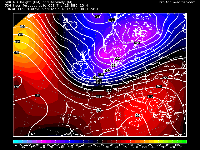
EPS control looks much more promising. That would be a chilly Christmas day with potential snow or snow showers on the backside of that low. Check out where the positive heights are…

Credit: AccuWeather Pro

Credit: AccuWeather Pro
500mb height anomaly
Credit: AccuWeather Pro
Both GFS ensemble isn’t available at the moment and the ECMWF deterministic only goes out to 240 hrs but I will be looking at the upcoming Christmas and New Year period in much more detail in the coming days so stay tuned!
NAO is firmly positive and we’re still getting winter weather. Hopefully the GFS ensemble is correct with it’s negative trend towards Christmas. If that materialises, we’ve a lot more significant winter weather heading our way! Not been bad so far though!
See video for the weather through the next week to 10 days!
[/s2If][s2If current_user_cannot(access_s2member_level1)][magicactionbox id=”18716″][/s2If]


")


Recent Comments