
This has got to be the toughest winter forecast since starting seasonal forecasts back in 2009. Following a long series of mild winters (except for a few decent cold shots), I called 2009-10 right as the first nasty winter ‘in a long time’. By calling a bad winter in the face of mild was a bold call. It was the bold call which ultimately put me on the map. So much so I got the attention of the newspapers and tv including STV and eventually the BBC. I also called 2010-11 right with a brutal start but following those two fairy tale winters, my accuracy dropped.
[s2If current_user_can(access_s2member_level1)]
Winter 2012-13 was ok with spells of snow and cold but it wasn’t the kinda of winter I had hoped. I overdid the amount of cold but it wasn’t a bust. That bust came last year when I called for what I thought was a cold, snowy winter ahead only to have egg on my face come January when just one WARM storm after another came and went aboard a record strong WESTERLY jet stream. Winter simply never showed up last year.
I hope to have learned from last year and I believe I have. By that I mean I see where I went wrong. I failed to see the solar max, albeit weak but enough to bring us NO BLOCK and all west winds thanks to the strong west QBO. A west QBO should have told me that no winter was coming!
This year is a very tough call. I see a lot of cold signals but are we in luck for a 2009-10/2010-11 repeat or simply a couple of decent winter blasts? Honestly? I don’t know!! I don’t want to be dubbed as a forecaster which ALWAYS calls for cold and 9 times out of 10 it doesn’t happen but 8 out of 10 things point to cold but it’s the 2 aspects (solar downturn & not minimum) that’s making me nervous.
ALL aspects both local and global which MUST come together for us to see a cold winter in my opinion are showing. Low solar, weak El Nino’s, wet autumns, early and greater than normal Siberian snow pack and even the resulting east QBO and -NAO/AO doesn’t guarantee a cold winter here but to have one, these more or less must be present and they appear to be this year. It’s just that nagging word ‘downturn’ in solar maximum and not MINIMUM like 2009 which is bothering me greatly Is the downturn and not minimum enough? Winters FOLLOWING an El Nino can be colder than winters which have an El Nino coming on. So this winter may be a build up to next year. We saw that in 2009-10 which had the nino coming on (very similar type to this year) and the start of the following winter (10-11) was more extreme.
So, it’s down to the SOLAR DOWNTURN and subsequent east QBO. Is it enough to build the adequate blocking high over the BEST place i.e the Davis Straits and west Greenland for us to see frequent cold troughs descend over the UK and West Europe?
I SHALL GIVE YOU THE VERDICT IN MY UPCOMING WINTER FORECAST!
before that, here’s some of the latest long range forecasts for the winter ahead.
Met Office 500mb anomaly chart for winter. It sees the blocking with negative extending from US to UK!
Sep version

Credit: Met Office
Oct version

Credit: Met Office
New Jamstec is wobbling some. Has a warmer Europe but keeps UK/Ireland cold.

It’s precipitation map suggests it has a Greenland block.
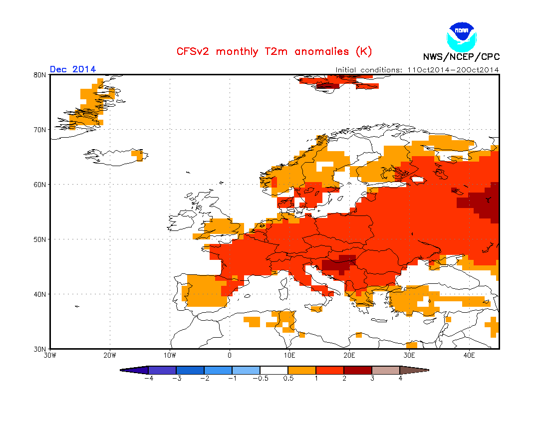
CFSv2 shows much the same. Contradicts itself between El Nino, global SST’s vs land temp anomalies.
SST anomalies for winter.

700mb height anomalies DON’T reflect the SST profile beneath!

Temp anomalies.


See this morning’s video for more on this.
[/s2If][s2If current_user_cannot(access_s2member_level1)][magicactionbox id=”18716″][/s2If]


")


Recent Comments