
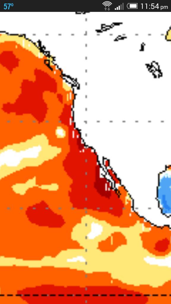
Norbert continues to weaken over colder waters further north up off the Baja Peninsula and looks likely to recurve into the northern Baja and Southwest US this week which will not just raise flash flood fears but will help bring much needed moisture.
Current Infrared imagery shows a poor and struggling hurricane with little to no precip on north side.

Norbert is crossing cooler waters now, helping the decrease in strength.

Courtesy/Owned by AccuWeather Pro
Current infrared shows a struggling Hurricane Norbert. It’s not just cooler water but a sea of dry air being entrained from California to it’s north.

Wide view of that dry air coming off California and wrapping around Norbert’s circulation.

Latest track forecasts take the system inland in a sharply weakening state but will contain beneficial rainfall.

Courtesy/Owned by AccuWeather Pro
Latest QPF for the next 7 days.

Courtesy/Owned by AccuWeather Pro

Notice the core of precip stays south and east of the worst drought areas of Calif. This SHOULD change later down the road…
[s2If current_user_can(access_s2member_level1)]
The Hope For A Fall And Wet Winter
Current drought severity

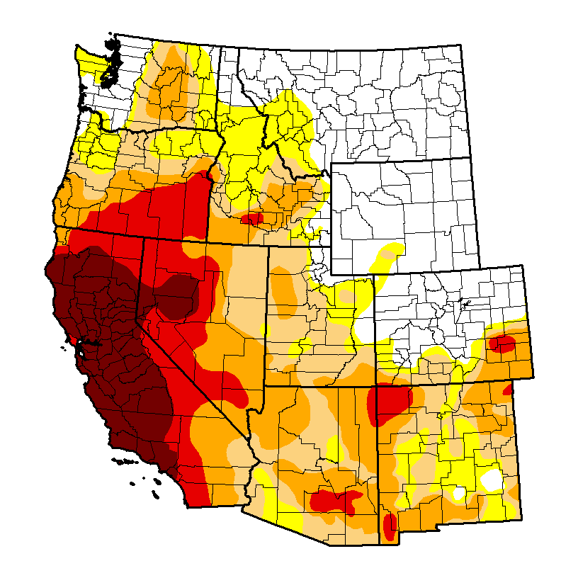

California Drought Stats
| Week | Date | None | D0-D4 | D1-D4 | D2-D4 | D3-D4 | D4 |
|---|---|---|---|---|---|---|---|
| Current | 2014-09-02 | 0.00 | 100.00 | 100.00 | 95.42 | 81.92 | 58.41 |
| Last Week | 2014-08-26 | 0.00 | 100.00 | 100.00 | 95.42 | 81.92 | 58.41 |
| 3 Months Ago | 2014-06-03 | 0.00 | 100.00 | 100.00 | 100.00 | 76.68 | 24.77 |
| Start of Calendar Year | 2013-12-31 | 2.61 | 97.39 | 94.25 | 87.53 | 27.59 | 0.00 |
| Start of Water Year | 2013-10-01 | 2.63 | 97.37 | 95.95 | 84.12 | 11.36 | 0.00 |
| One Year Ago | 2013-09-03 | 0.00 | 100.00 | 97.08 | 92.94 | 11.36 | 0.00 |

Credit: Prepared For That
Groundwater levels have turned dire this summer following a 3 year downward trend in rainfall.

Lake Mead reached it’s lowest levels since it’s construction back in July.

Courtesy/Source: NWS San Francisco
Incredible photo taken back on Aug 25th shows a drying up Lake Shasta. Only 30% capacity.

Courtesy/Credit: California Department of Water Resources.
There is hope….

Courtesy/Source: NWS San Francisco
What the NWS are saying about El Nino and rainfall expected in Southern California.
While the warmest water compared to normal ‘should’ be in the central equatorial Pacific come winter, I believe for the first time in several years, warm water up the Baja and California coasts should support an active southern branch jet and storm train into California and Southwest during winter 2014-15 bringing crucial relief to this increasing, historic drought.
Norbert shall bring additional rains to an increasingly wet Southwest but INCREASING winter precipitation with an active storm track comes later once the semi-permanent Pacific high weakens and lifts north and warm water’s feedback to lower pressure and increasing precip.
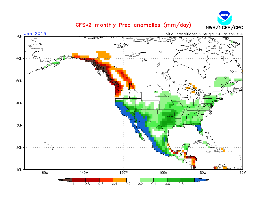
Notice with the CFSv2 rainfall for the upcoming months below and it’s above normal rainfall anomaly particularly mid and LATE winter for California.
CFSv2 shows the abnormally warm water off Baja and Calif during the winter of 2014-15. The past 3-4 years have seen cold water here.

Here’s the precipitation forecasts.


Be sure to watch today’s video for the discussion to this write-up.
[/s2If][s2If current_user_cannot(access_s2member_level1)][magicactionbox id=”18716″][/s2If]


")


Recent Comments