
It’s been a cool summer and cool year overall for the US, pretty much opposite of the UK and Western Europe.
Like with Europe, in today’s post I want to compare my US summer forecast issued back in April with what actually happened. Like with winter 2013-14, I think you’ll agree that it’s been a pretty good forecast.
June was warm and warmer than thought!

Source/Credit: High Plains Regional Climate Center
July was cool as expected over the nations Heartland and Midwest in particular.
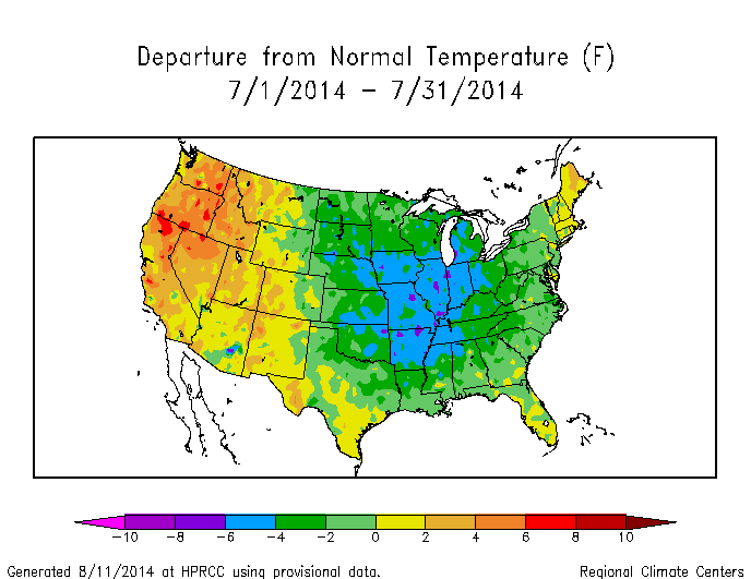
Source/Credit: High Plains Regional Climate Center
Similar but not as extreme as July 2009
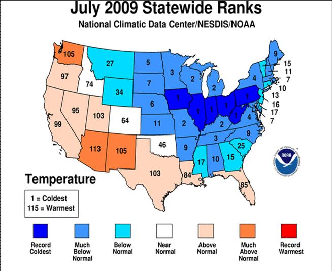
Both July 2009 and 2014 produced all-time record cold highs and lows.
August was warmer on the Plains but cooler both west and east.

Source/Credit: High Plains Regional Climate Center
It was cool for much of the country when combining the June through August period.
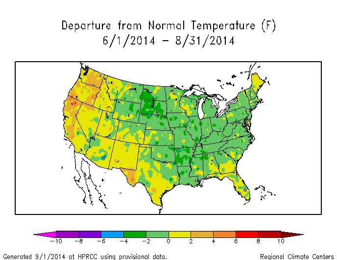
Source/Credit: High Plains Regional Climate Center
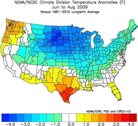
Summer 2014 was similar to summer 2009 but like the July’s, 2009 was more extreme!
As well as cool, it’s been a wet.

Here was my forecast issued back in April
Official United States Summer Forecast 2014
For a good couple of months now I have had a cooler than normal spring and summer across a large swath of the United States.
The focus being over the areas which suffered the worst of winter. The region surrounding the Great Lakes continue to see spells of snow and unusually cold air by mid to late April standards. Up until just this week, parts of the UP of Michigan have been STILL enduring sub zero night-time lows. Later occurrences than ever before.
Despite short lived spells of warmth, the Great Lakes has held onto a remarkable 35-40% ice cover thanks to the winter just gone and the very cold March and April but this will have significant impact further down the road.
The warm water over the Gulf of Alaska which helped hold a strong Alaska ridge during winter will likely help with a warmer than normal summer over the Western US, Alaskan and NW Canada.
The combination of a still solid ice cover on Hudson Bay, a remarkably expansive snow cover over most of Canada and still icy Great Lakes waters, frequent shots of chilly or even cold air will continue to drive into the Midwest and East well into summer this year.
As of April 19, we still have 36.7% ice cover on the Great Lakes.

Here’s the contrast between April 16 this year to recent years.

North America snow and ice on April 19. WAY above normal! This will highly refrigerate any northerly air flow into the Lower 48 well into May!

Thanks to the overwhelming chill this spring so far and just like last year, the tornado count extremely low, in fact it’s record low.

Unfortunately, this looks set to change. I’ve made mention for some time now about the natural building of heat over the sub-tropics (Mexico) and how it’s only a matter of time before we get that battle between warm and cold. Most of the time, warmth overwhelms the pattern but this year like many in recent times has seen more resistance from cold and so raise the thermal gradient across the country and you’ve an increased severe weather risk.
The still active Pacific storm track means hot, moist air and cold, dry air will fuse together, increasing the potential for a significant severe weather and tornado outbreak.

One concern was that warmer than normal water either side of Mexico (above), may support warmer air masses that try to lift up into the US. The central Gulf is also warmer than normal and this may push moister air north. The still solid Canada snow cover, persistent ridging over the northwest continent, means cold air will continue to try and push south, slamming up against the heat and humidity trying to push north.
Like last year, we saw some nasty tornado outbreaks later in the season and that is a fear of mine this year.
So, OVERALL, it looking cooler than normal from the Midwest (possibly Plains), eastwards this summer but where will the heat be?
The combination of the likely continued Alaska ridge and severe drought over California and West, suggests a warmer than normal summer from California to Rockies.
Here’s the latest drought map as of April 15. The ridge and heat likes to go to where that dry ground is.

Close up view of the West. Darkest red shows most severe drought and it’s expanding over California and we’re heading for the dry season.

As for rainfall, it’s no surprise that we should expect drier than normal across the West but some relief should come during the second half of summer with the Western monsoon kicking in.
I expect a wetter than normal summer in the East and with wet ground, especially in the Southeast currently… wet soil and cooler conditions go hand in hand. Wet ground encourages more rainfall and we saw this last summer in the Southeast. Need to watch for tropical cyclone activity which may really jack up rain totals this year.
The Northeast may see a near average summer regarding both temperature and rainfall but one must not ignore the warmer than normal waters lurking off the East Coast which may support warmer nights and possibly increased rainfall which could help make for a slightly warmer than normal summer from Philadelphia north.
The coolest zone will be the area surrounding the Great Lakes. It should be a back and fourth summer but cool should rule. Northern Plains may see a fight with spells of heat lifting up from Texas and the Southwest but cooler northwesterly air flows out of Canada may bring cool, cloudy, even wet spells frequently.
Texas looks hot and dry through the first half but it may turn cooler and wetter late in July and August, helped by a possible increase in tropical activity.
The CFSv2 consistently shows a normal to below normal summer from the Rockies east, warmer than normal from California north. Precipitation is above normal where it’s cool.
May-July Temps

May-July Precip

June-August Temps

June-August Precip

[s2If current_user_can(access_s2member_level1)]
[/s2If][s2If current_user_cannot(access_s2member_level1)][magicactionbox id=”18716″][/s2If]


")


Recent Comments