
A lot of attention is drawn these days to global warming and the earth heating up, bringing greater floods, heat waves and droughts than ‘ever before’, yet the media and governments bypass what’s happening down under where the Antarctic is breaking records for GREATER THAN EVER BEFORE ICE EXTENT while SE Australia get’s smacked by a major snowstorm which brings the best open to a ski season in a decade.
Snow as good as it gets on Australian Alps
Source Weatherzone Wed 25 Jun 2014
As much as 40-to-100 centimetres of fresh snow has fallen across the Alps in the last few days and there is plenty more to come. Strong wind and snow showers will ease during the next few days and snow showers should clear during Friday as a high pressure system takes over. From Saturday an intense low, similar to the one which brought the recent dump, will sling a few strong cold fronts across southeastern Australia during the following few days, bringing heavy snow, very strong winds and blizzards to the Alps. Most snow should fall on Saturday with some resorts a good chance to gain more than 50cm, most likely Mt Hotham/Falls Creek. On Sunday snowfalls will generally ease but there is still potential for a further 50cm or more, most likely Thredbo/Perisher. Snow showers and wind will ease during Monday before snow clears during Tuesday and Wednesday, leaving the slopes with as much fresh powder as you get at this time of year. By this time next week there is a fair chance for one-to-one-and-a-half metres of fresh snow lying on the slopes. There are signs of warming during the following week, so it is encouraged to get amongst it before too much snow melts. It might be a while before decent snow returns. On the bright side, the melting snow will flow downstream for days to come, rejuvenating rivers. The Murray and Murrumbidgee may still be flowing fast well into next week. – Weatherzone © Weatherzone 2014
According to the BBC, some higher spots within the Victorian Alps have seen temps down to -20C!
[s2If current_user_can(access_s2member_level1)]
SOUTHERN HEMISPHERE ICE EXTENT NEARS ALL-TIME RECORD
As for Southern Hemisphere ice extent, a lot of attention in the global media is drawn to melting but not growing ice.
In recent years, the arctic summer ice extent has been incredibly low, largely down to the ‘peaking’ of the warm AMO but in stark contrast, the Antarctic sea ice has been growing, in fact it’s been breaking all sorts of records and this year looks to be on track for the greatest sea ice extent in recorded history.

Interestingly, the AMO went ‘temporarily’ into a cold mode and remains so. As a consequence, the CFSv2 actually has the arctic summer ice extent above normal for the first time since 1996.

The below chart shows the decline in arctic sea ice extent including record lows in Sept 2007 and 2012 as the warm phase of the AMO likely peaked.

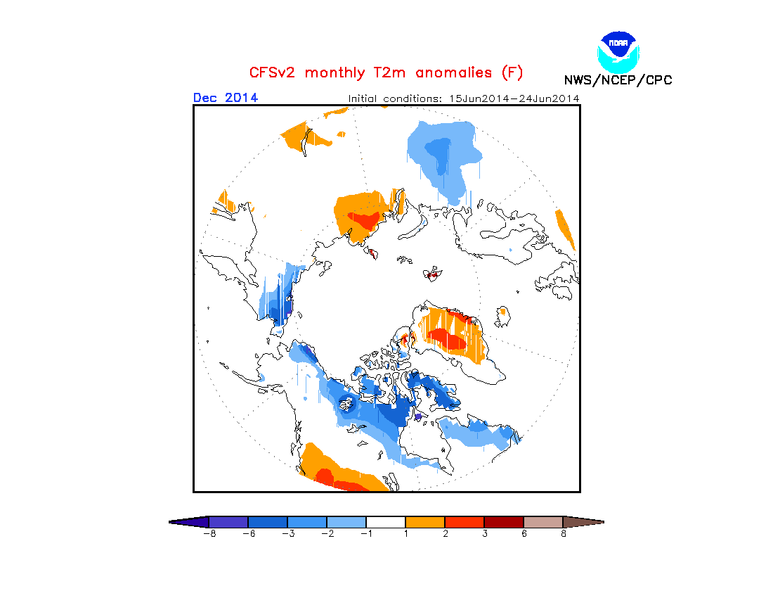
With the vast extent of Antarctic ice, we could see colder times throughout this winter across Australasia and parts of South America. Note the CFSv2 has a cold July for both. Warm over southern Africa though.

Jamstec has a cold Australia winter (June-August) but it’s warm over southern South America but cold in South Africa.

To me, it’s an atmosphere/ocean balancing act with shrinkage in the North and expansion in the South.
As well as watching this winter’s southern hemisphere ice extent and likely cold/snow blasts into New Zealand and Australia as well as perhaps South America, next winter in the Northern Hemisphere sure will be interesting to watch if arctic sea ice is greater than in recent years. Stronger southward cold surges are possible. Of you notice, the model shows arctic sea ice going from above in summer to below in winter, that’s likely because the model is seeing northern blocking which in turn means cold times ahead for the mid-latitudes of North America, Europe and Asia.
Here’s the CFSv2 arctic 2-metre temp anomalies for December 2014.
[/s2If][s2If current_user_cannot(access_s2member_level1)][magicactionbox id=”18716″][/s2If]


")


Recent Comments