>
Join The Conversation!
NEW WEBSITE COMING SOON!
In Today’s Blog
Latest UK-Europe Discussion @ #UK-EUROPE
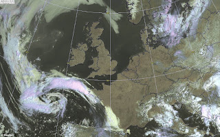
Did You Enjoy Life In The Mediteranean Over The Past 7 Days? UK/Ireland Returns To Normal By Tues/Wed As Ridge Breaks
EUROPE LATEST
From Freezing To Frying, May Has Seen A Dramatic Reversal With Record Heat Extending From North To South, Now Thunderstorms May Finish Things Off In Style
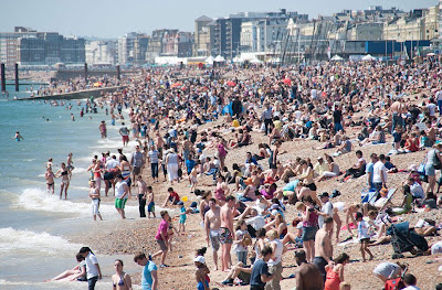
It’s amazing how a week of glorious weather can daze us into forgetting how April played out and how May started off and continued to be through the first 18 days. Since the cold rains, snow over the Highlands and Pennines and -7C mornings, we have all enjoyed a spectacular 8 days of unbroken sunshine and Mediteranean warmth. Of course we aren’t use to very warm weather and so many await a cooldown.
While some parts from the North Sea coast and even across to the western Central Belt cooled on Saturday to the ‘low 70s’ as a stiff east wind blew. This followed a record May high of 81 degrees F in Glasgow the day before.
While Glasgow reached their highest level in May on record, so too did St Bees Head, located right on the Cumbrian coast. 27.8C was reached here thanks to strong high pressure which brought maximum sinking, helped by a stiff east wind howlling over top of the Cumbrian Fells which downsloped and helped heat the air right to the coast.
Records fell even down along the South coast at Bournemouth where we saw a high of 28.5C, a record and unusually warm reading for normally cool, sea bgreeze influenced town. Thanks, like St Bees Head was thanks to ‘offshore’ winds which meant any cooling from the sea was cut off and heat from inland headed for the coast.
At all points between Caithness and Kent we saw temps top 25 to 28C with a particularly warm spot, Kinlochewe situated near the coast right up in far northwest Scotland where two straight days saw their high top 28C. Friday’s 28.7C and Saturday’s 28.1C fell within 1C from the all-time May record for Scotland, that’s how significant this spoell of weather has been. Again, like in Bournemouth, St Bees Head and many other west or south coast communities which in fact saw some of the warmest readings in all of the UK, it was not only the powerful upper level high and it’s deep warmth through the atmosphere which supported unusual upper 20s but wind played a big role, both bringing downslope compressional warming as well as shutting off the natural sea breeze. East or northeast winds blew hot air from the land towards the coast!
US LATEST
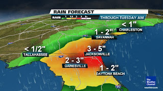
Subtropical Storm Beryl Strengthens To 60 mph, Set To Bring 3-6, Locally 10″ Rains, Major Heat Covers Central & Eastern US While Snow Falls Over Montana & Wyoming
I SHALL BE ON THE ROAD DURING THE TIME BERYL SHOULD MAKE LANDFALL, CHECK OUT MY FACEBOOK & TWITTER PAGES FOR FREQUENT UPDATES!
Week Ahead: Beryl Lingers, Heat Relief and More!
THE WEATHER CHANNEL
Beryl Approaching the Florida Coastline
FIRSTHANDWEATHER
Beryl Taking Aim on Jacksonville, North Florida
ACCUWEATHER
Damaging Hail Threat From Minnesota to Kansas
ACCUWEATHER
Severe Weather: Forecast, Warnings and More
THE WEATHER CHANNEL
ASIA LATEST
Sanvu Decays, Pushes Out Into The North Pacific
THE EXTREMES OF THE DAY
TODAY’S EXTREMES HERE AT MY HOUSE
HIGH: 79
LOW: 49
Thanks for reading.
-Mark


Recent Comments