>
In Today’s Blog
– Mark Vogan’s Long Range Video (below)
– Latest Info & Track Scenarios for US East Coast Snowstorm (below)
Today’s Global Weather Headlines
Europe Latest
Azores High Spoils UK-Ireland With Spring-like Warmth But Winter Set To Roar Back With A Vengence By Saturday

The UK continues to enjoy spring-like weather thanks to a high pressure system positioned to our southwest which is pumping very mild air north, northeast around the high’s core which is centred just north of the Azores Islands. The large coverage of this high is shielding any cold away from the UK by a large distance and that is why even a typically cold northwest flow isn’t drawing down colder air. Have you noticed how the flow is coming in from the W, NW, not typically associated with mild weather for us at this time of year, right? Well, it’s due to the expanse and coverage of this high and how the air originates near the Azores, travels north and then bends around, south of Iceland, not actually tapping any cold air. You have to head way up to Iceland and Greenland for some cold air. That very air however will arrive with a vengence behind a cold front Friday into Saturday.
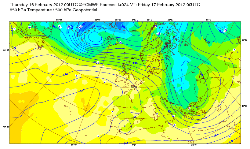
Tomorrow will see a return to cooler temperatures across Scotland and Friday into Saturday, a sharp cold front will advance southwards over the UK and Ireland. My fear is that we may see rains associated with this front turn rapidly to snow as the cold air drives in.
Scotland could go from a relatively mild 5-7C to around freezing within an hour or so with rain changing rapidly to snow which could create blizzards up over the Highlands and nasty travel even across the Central Belt. By Saturday night, I wouldn’t be surprised to see much of the Central Belt blanketed in a quick 1-2 inches of snow. The big problem is knowing how much moisture will be available along the front.

Throughout Saturday, this cold front will sweep south bringing similar rapidly changing conditions well into England with very tricky travel over Trans-Pennine routes. Heavy snow may fall as far south as Manchester, perhaps even the Midlands and Lincolnshire.
Saturday night could bring a real reality check to Scots and possibly the Irish as we find ourselves covered by fresh snow and if skies clear out long after the rain to snow bearing front has passed and a much more Arctic air mass is established, a very cold night may be in store as that air is blowing straight down from the Arctic.
By Sunday, I believe many towns and cities from Caithness to Cheshire may struggle to hit freezing.
How has February fared so far?
BBC
Drought risk for parts of England
BBC
Rome Colosseum Damaged by Snow, Frost
ACCUWEATHER.COM
US Latest
Is There Or Isn’t There An I-95 Corridor Snowstorm?

There is still a lot of uncertainty over this upcoming weekend’s weather over the East and whether we shall be seeing a snowstorm up the coastal Northeast which could bring several inches to the major cities or does the swathe of snow spread more west to east, bringing more to the Mid-Atlantic and barely anything further north.
VIDEO: Rain, Ice, Snow in East Thursday. Big Weekend Snowstorm?
ACCUWEATHER.COM
Winter Storm for the Northeast this Weekend?
THE WEATHER CHANNEL
Snowstorm Close Call for DC, Philly, NYC This Weekend
ACCUWEATHER.COM
Severe Weather Is A Threat Once Again This Weekend, Soo Too Is Flooding!
Violent, Dangerous Severe Storm, Tornado Outbreak
ACCUWEATHER.COM


Setup For The Snowstorm


The below graphics and explaination is courtesy of The Weather Channel which I believe shows clearly what’s on the table for this weekend.
Scenarios for this Weekend
Below are three graphics showing three different scenarios for the East Coast this weekend.
The first one, which is what we think is most likely at this point, shows the area of low pressure sweeping through the Mid-Atlantic States, then out to sea, wrapping enough moisture around its circulation for accumulating snow (possibly starting as rain) in the Mid-Atlantic States. This scenario would produce accumulating snow in Philly, Baltimore, and Washington, D.C., and possibly as far north as New York City.
However, we will be watching closely for possible alternative tracks including the scenarios depicted in the second and third graphics.
The second graphic shows the low sliding farther out to sea, producing little snowfall, except in the central and southern Appalachians and adjacent lower elevations of Virginia and North Carolina. In the third graphic, the low tracks much closer to the coast, producing rain along the I-95 corridor and snow (possibly heavy) in the interior Northeast including Upstate New York and parts of New England.

Scenario #1: System moves close enough for Mid-Atlantic snow, with little/no snow in New England

Scenario #2: Low tracks out to sea, with snow mainly in ctrl./srn. Appalachians, but little elsewhere.

Scenario #3: System moves closer to coast or inland, producing mainly rain along I-95 to coast and interior snow, possibly heavy.
Santa Ana Winds Buffet Southern California
ACCUWEATHER.COM

Australia Latest
THE EXTREMES OF THE DAY
TODAY’S US EXTREMES
COURTESY OF ACCUWEATHER
HIGH: 84° at Plant City, FL
LOW: -22° at West Yellowstone, MT
TODAY’S UK EXTREMES
COURTESY OF THE MET OFFICE
HIGH: 56° (13.5°C) at Leuchers (Fife)
LOW: 31° (-0.8°C) at Topcliffe (N. Yorkshire)
TODAY’S EXTREMES HERE AT MY HOUSE
HIGH: 52°
LOW: 36°
Thanks for reading.
-Mark


")


")
Recent Comments