>
Europe Latest
Another very stormy week ahead with more ‘rapidly deepening lows’ crossing Ireland, the UK and into Scandinavia
More 90-100 mph wind gusts expected along with flooding rains but where does this next batch of nasty take aim at?
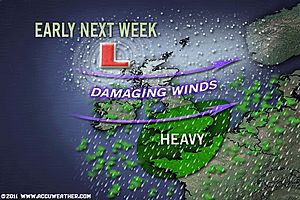
The track of these systems is crucial as to where the strongest winds will hit. It appears, the strongest winds will rival last Thursday’s storm which practically brought Scotland to it’s knees and where those will be is still difficult to call but my guess would be southern Scotland and northern England
The first low which according to the latest models, may take a similar track to last Thursday’s but it appears to look stronger with last Thursday’s being 957mb while this one appears to look at 948mb, that’s a good deal stronger.
OVERALL ATMOSPHERIC ENVIRONMENT AND UPPER LEVEL DYNAMICS VERY CONDUCIVE FOR RAPID LOW PRESSURE DEEPENING
With the overall ingredients the same as last week with a powerhouse Atlantic jet stream, lows forming along this super fast flowing ribbon of air, rapid deepening is likely with unlimited high-octane over Greenland to the north and northwest and sub-tropical warmth and moisture over the Azores to the south.
It’s once these systems near Ireland that these systems go to town so to speak, dropping some 24 to 50mb inside 36 hours as the circulation pulls up this warm, moist sit along it’s leading cold front and wraps it into it’s centre as well as pulls that frigid air down on it’s rear. Because this warm and cold air doesn’t mix, the windfield tighens and the central pressure lowers and as a result, winds increase, it’s simply natures way of trying to neautralise the imbalance created by this infusion of conflicting warmth and cold.

The danger to a system continuing to deepen on approach to a land mass is that they can often produce much more destructive winds and also transfer jet stream energy down to the surface. Jet stream winds blowing over 200 mph were quite possibly pulled down to the mid-levels thus explaining why Cairngorm Mountain in the Central Highlands of Scotland recorded a wind gust to 165 mph, a category 5 hurricane-force gust.
Stronger central pressures and the fact these lows will pretty much cross land, means a justifiable cause for concern, especially when the highest wind cores take aim at highly populated areas. That was the reason for such concern last Thursday as the stongest winds appeared to aim directly into the Central Belt from the west and with a generally west to east valley with the Highlands to the north and Southern Uplands to the south, these winds could in effect funnel uninterupted through the M8 corridor with little friction from sizeable hills to slow down powerful, damaging and very disruptive winds. 3 major bridges oriented north-south would suffer extreme side wind gusts and this was the case with the Forth Rd Bridge experiencing an 84 mph gust and an even more impressive 106 mph gust recorded on the Tay Rd Bridge, by far strong enough to blow vehicles off these bridges.
SNOWFALL TO WHITEN THE GROUND DEEPER INTO ENGLAND/WALES ON THE REAR OF THESE CIRCULATIONS?
On the rear, a blast of cold air will increase the snow chances but this time it looks to support snow further south.
GFS POINTS TO UGLY SCENARIO NEXT WEEK WITH DOUBLE BLOWS BY POTENTIALLY TWO SYSTEMS STRONGER THAN LAST WEEKS
According to the GFS which isn’t the most reliable model and of course only one of many, it currently points to a STRONGER system arriving late Monday through Tuesday than last week’s storm with strongest winds may taking aim at the SAME AREAS that got battered last week. While last week’s central pressure was around 957mb as it passed over northern Scotland, this one appears to have a pressure down to 948mb.

AN EARLY GLANCE AT THE 2ND STORM LATE NEXT WEEK
The below map for Friday looks very frightening, even worse than the Mon-Tues system with a central pressure in this storm set to plunge to 938mb, this of course is very speculative and likely will change quite a bit between now and late next week but even the fact that the model shows this is amazing. That is exceptionally low pressure, perhaps record challenging. Now, the deeper the low, the stronger the storm and the stronger winds can blow. Notice where the centre is located by Friday, then notice where the strongest winds are, practically in the same area as where last Thursday’s strongest winds were in Scotland. What’s worrying is, that if this actually happened, this would actually support even stronger winds, possibly hurricane-force sustained and gusts in excess of 100-120 mph or higher, yes in the populated Central Belt. This would be a devastating scenario for Central Scotland but I wouldn’t buy into this scenario. I’m meerly having some fun, it’s simply too early to pinpoint details.

More storms head towards the UK
BBC
Stunning winter moon beaming down across a frozen Reykjavik, Iceland tonight
These breathtaking photos below were taken by my Facebook friend Jon Gustafsson this evening, he told me that temps have been down to -10C in Reykjavik which is cold even by their standards and to the north, within the Highlands it’s been as cold as -20C in recent nights.
Jon, is a world class photographer/videographer as well as a director, writer and producer.
Please check out his website to see more of his work


US Latest
Milder air flows up into N. Rockies/Plains ahead of next Pacific Storm
Lake-Effect Snow to Wrap Up Tonight
ACCUWEATHER.COM
Another Great Weekend for the I-95 Northeast
ACCUWEATHER.COM

Rain, Gusty Winds to Buffet Florida Beaches into Monday
ACCUWEATHER.COM

Mild December Follows Frigid November in Interior Alaska
ACCUWEATHER.COM
Coldest start for Chicago

Cold air, wind and Lake Superior come together to produce beautiful icing at Grand Marais, Minnesota
Photos Courtesy of the Grand Marais Facebook page


Canada Latest
Winds blast Newfoundland and Labrador
UPI.COM
THE EXTREMES OF THE DAY
TODAY’S US EXTREMES
COURTESY OF ACCUWEATHER
HIGH: 82° at Fort Myers, FL
LOW: -11° at West Yellowstone, MT
TODAY’S UK EXTREMES
COURTESY OF THE MET OFFICE
HIGH: 49° (9.4°C) at Isles of Scilly
LOW: 18° (-7.8°C) at Braemar (Aberdeenshire)
TODAY’S EXTREMES HERE AT MY HOUSE
HIGH: 42°
LOW: 23°
Thanks for reading.
-Mark


")


Recent Comments