>
In Today’s Blog
Latest US Discussion @ #UNITED STATES
Stormy Conditions get cranking across Midwest and East Coast today
Latest UK-Europe Discussion @ #BRITISH ISLES-EUROPE
Milder Weather Returns to UK over the 12-24 hours setting scene for remainder of month but not before coolest night of new season
Today’s Weather Headlines
US Latest
Midwest & East Coast Begins the Soaking!
Lakefront path closed in wake of area wind, wave and flood warnings
CHICAGO TRIBUNE
Forecasted Waveheights on Lake Michigan

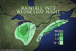
Tropical Rain Renews Northeast Flood Threat
ACCUWEATHER.COM
Florida Tornado Damaged and Drenched by nearly 2 FEET of rain in 5 days
Days of Heavy Rain, Strong Storms in South Florida
THE WEATHER CHANNEL


Chilly Start from North Dakota to North Texas, Coldest start in Dallas, TX since mid-May

Cold Wednesday ahead compared to normal from North Dakota to Georgia

Colorado, New Mexico Snow Patrol for Next Week
ACCUWEATHER.COM
Canada Latest
Warmest spot in Canada so far today: Claresholm, Alberta @ 19.8C (68F)
Heavy rain to drench eastern Canada
THE WEATHER NETWORK


Europe Latest
Tonight to be chilliest night with widespread UK frost, freeze ending cool spell, typical of October, milder but unsettled weather returns tomorrow and looks set last into Nov
My low of 30 degrees F (-0.9C) this morning marks first below freezing reading since May, produced frost and some light icing on birdbath!
After a chilly few days throughout the UK with cold winds, hill snow and temperatures below normal, the chilly trough and weak Arctic air, made worse but the exceptionally mild start to October is set to move out as fast as it arrived. Tomorrow will see a return to Atlantic driven mild, unsettled weather with a growing SW wind carrying rain west to east and removing the colder air.
Looking ahead, the Atlantic storm train looks set to intensify, turning more zonal (keeping warmth to the south, cold to the north and thus bringing frequent Atlantic depressions directly across the UK west to east. This setup brings with it strong pushes of mild, moisture rich air on board a strong Atlantic jet stream, little cold air is to be had in such a pattern. The hemispheric pattern flips to a more oceanic dominated pattern for both North America & Europe to end October as the NAO, AO returns to a positive phase and the cold air retreats back north to charge up for the winter ahead.
See more details on longer term UK pattern on the #BRITISH ISLES-EUROPE tab
UK Frosty Early Thursday
ACCUWEATHER.COM

Asia Latest
Tropical Cyclone Landing near Bangladesh-Myanmar Border
ACCUWEATHER.COM
TODAY’S POST WILL BE UPDATED THROUGHOUT TODAY WITH NEW STORIES, PHOTOS AND VIDEO, STAY TUNED!
THE EXTREMES OF THE DAY
TODAY’S US EXTREMES
COURTESY OF ACCUWEATHER
HIGH: 102° at Gila Bend, AZ
LOW: 13° at Alamosa, CO
TODAY’S UK EXTREMES
COURTESY OF THE MET OFFICE
HIGH: 58° (14.7°C) at Solent (Wight)
LOW: 31° (-0.4°C) at Tyndrum (Stirlingshire)
TODAY’S EXTREMES HERE AT MY HOUSE
HIGH: 46°
LOW: 30°
Thanks for reading.
-Mark


")


")
Recent Comments