>
In Today’s Blog
Latest UK Discussion @ #BRITISH ISLES-EUROPE
Unsettled Pattern remains through the new workweek with new band of rain moving through Ireland tonight and into western mainland of UK through Mon morning
Latest US Discussion @ #UNITED STATES
Weather rather quiet across the US, except for a Severe Weather Threat across the Nations midsection tonight
Today’s Weather Headlines
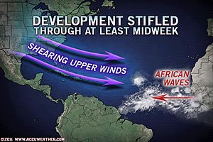
This week may be quietest for both the tropics and weather in many weeks! – Mark Vogan
NEW: Northeast Weather’s 2011-2012 Preliminary Winter Forecast (recomended read!)
Hurricane Season in the Atlantic Comes to a Screeching Halt
ACCUWEATHER.COM
6.8-magnitude quake strikes northern India
CNN
Hurricane Irene Devastates Pumpkin Crops in Northeast US
ACCUWEATHER.COM
Flash Flooding at Jacksonville Beach Area
THE WEATHER CHANNEL

Cost to Fix Flood Defenses Far Exceeds Funding
THE WEATHER CHANNEL
Winter’s Brief Visit on Mt Washington, NH (By Brian Clark)
Sep 18, 2011; 9:48 AM ET
Everything went pretty much as I expected it to since I updated last. Temperatures bottomed out at 23 degrees early in the day on Friday the 16, which was admittedly slightly warmer than I expected. Winds were sustained around 50-60 mph for most of the day Friday, before diminishing slightly during the afternoon. Several feet of rime ice formed on the windward side of everything outside. One thing that was a little unexpected was the amount of snow that fell on Friday. Although I figured we would see a snow shower or two that probably wouldn’t amount to much, we ended up with a total of 0.8 inches of measured snowfall that came from on and off upslope snow showers during the day on Friday. We also measured 0.1 inches of ice pellets late on Thursday, for a storm total of 0.9 inches. The 0.8 we measured in a 24 hour period matched the most snow we’ve seen in one day in September since 2002. However, no records were broken, snowfall related or otherwise, during this cold snap.
Fog then cleared off just after sunrise on the 17th, and revealed some very nice views. I absolutely love the contrast that occurs between the valley and the higher terrain this time of year. In fact, it’s one of my favorite things about the fall season on Mount Washington. I took quite a few pictures, some of which turned out very nice. I’ll hold onto those pictures until the end of my shift, and post them along with the rest of the pictures that I end up taking this shift.
As the title of this entry suggests, this taste of winter was (relatively) brief, and we’re moving back to more seasonable conditions for the short term. The rime ice and snow that we did get is disappearing quickly, as it always does this time of year because of the angle of the sun and the fact that the ground isn’t really frozen yet. It won’t be until October that snow and ice will likely be here to stay for the winter.
Checkout Brian Clark’s blog
Henry Margusity: AccuWeather’s Resident Crash Daddy
ACCUWEATHER.COM


")


Recent Comments